Margidunum facts for kids

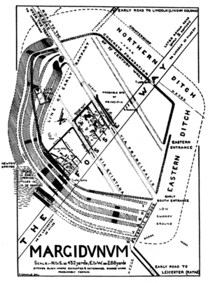
1927 plan of Margidunum
|
|
| Location | Bingham |
|---|---|
| Region | Nottinghamshire, England |
| Coordinates | 52°58′2″N 0°57′35″W / 52.96722°N 0.95972°W |
| Type | Settlement |
| History | |
| Periods | Romano-British |
| Site notes | |
| Condition | Buried remains |
| Public access | Footpath |
| Official name | Margidunum Roman Station |
| Reference no. | 1006395 |
Margidunum was an ancient Roman settlement. It was located on a Roman road called the Fosse Way. This place is near modern-day Bingham in Nottinghamshire, England. Today, Margidunum is a protected historical site. It is known as a Scheduled Monument. This means it is an important place that is kept safe.
What Was Margidunum?
The name Margidunum comes from Latin. It means 'marly fort'. Marl is a type of clay soil rich in lime. An archaeologist named Felix Oswald studied the site. He thought the Romans used an older local name. He believed its Celtic meaning was "the fort of the king's plain". The raised ground here was a good spot for a fort. It might have been a hill-fort for the king of the Coritani tribe.
Margidunum on Roman Maps
The Antonine Itinerary was a Roman register of places and roads. It was made in the 2nd century. This register shows Margidunum as MARGIDVNO. It was located halfway between Ratae (modern Leicester) and Lindum (modern Lincoln). All these places were connected by the Fosse Way.
Early Military Post
Archaeologists found military equipment at Margidunum. This shows it started as a military post. This was around 55–60 AD. No fort structures have been found yet. Roman forts were built close together along the Fosse Way. They helped protect Roman lands. This was important because of tribes like the Brigantes and Iceni.
How the Settlement Grew
A civilian settlement began to grow around 70–80 AD. It spread out on both sides of the Fosse Way. Simple rectangular buildings were found along about 1 kilometer of the road. Two Roman villas were also found nearby. These were large country houses. Roman farms were also in the surrounding area.
Defenses of Margidunum
Around the late 2nd century, a defense was built. It was a rhomboid-shaped earthwork. A rhomboid is a shape like a diamond. This defense enclosed about 7 or 8 acres. Later, a stone wall was built in front of the earth rampart. This wall was almost 3 meters wide. There were also two ditches outside the wall. Marshland protected the fort from the south and east. People continued to live at Margidunum until about 500 AD.
Discoveries at Margidunum
Many people have explored Margidunum over the years. They have found exciting clues about its past.
Early Visits and Finds
In 1722, a man named William Stukeley visited the site. He wrote about his observations in a book in 1724. He saw Roman wall foundations and house floors. He also noted regularly-spaced oak posts. In 1896, people reported finding Roman pottery and coins. This was in a field called 'Castle Hill Close'.
Modern Excavations
Nottingham University led excavations in the 1920s. These were done by Felix Oswald. More digs happened in the 1960s by Malcolm Todd. Oswald found very old items. These included a Bronze Age flint arrowhead. He also found polished stone axes and bronze tools called celts.
Roman Buildings and Life
The 20th-century digs uncovered many Roman buildings. They found stone walls and floors. Some floors were made of stone slabs, others of beaten clay. Over 20 Roman buildings were found. Three large buildings were next to each other. They seemed to be the most fancy.
Archaeologists found pieces of window glass and roof tiles. They also found signs of underfloor heating. This means one building was likely a bathhouse. It would have had stone walls. Other buildings were made of timber frames. Their walls were made of wattle and daub. This is a mix of woven sticks and clay. The largest building had no inside walls. It was probably a public building.
Other finds included decorated wall plaster and mosaic floor tiles. Pottery, a grid iron, and charred wood were also discovered. Several wells and water tanks were found. The oldest well was from the time of Claudius. It was lined with oak planks. Later wells were lined with stone. These wells got water from nearby Newton Springs.
Roman Roads and Trade
Felix Oswald also found traces of two other roads. These roads crossed through the camp. He thought one road was used to carry lead. This lead came from the Lutudarum lead-mines in Derbyshire. This idea came from a large lead ingot found in 1848. It was found near Mansfield. The ingot had a Roman inscription on it.
Margidunum Today
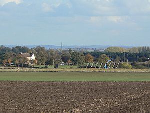
Most of the Margidunum site is now under three fields. Part of it is also covered by a roundabout. This roundabout was built in 1968.
Nearby Roman Sites
Other Roman sites are found close to Margidunum.
Ad Pontem Fort
The Roman fort of Ad Pontem was about 10 miles north. It was near East Stoke and Newark. It was a small fort from the 1st century. It also had a rhomboid-shaped earthwork. A settlement grew there, and Romans lived there until the 4th century. Two Iron Age huts were also found at this site.
Other Roman Camps
Roman camps have also been found nearby. These are at Calverton and Farnsfield. Both of these sites are also protected Scheduled Monuments.
See also
 In Spanish: Margidunum para niños
 | Janet Taylor Pickett |
 | Synthia Saint James |
 | Howardena Pindell |
 | Faith Ringgold |


