Schriebers Meadow Cone facts for kids
Quick facts for kids Schriebers Meadow Cone |
|
|---|---|

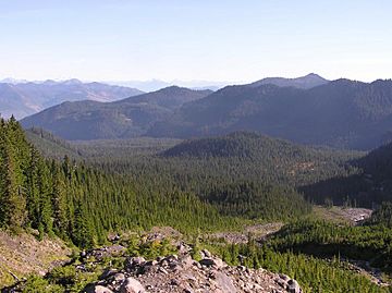
Schriebers Meadow Cone is the tree covered mound in center
|
|
| Highest point | |
| Elevation | 3,640 ft (1,110 m) |
| Geography | |
| Location | Whatcom County, Washington, U.S. |
| Parent range | Cascade Range |
| Topo map | USGS Mount Baker |
| Geology | |
| Mountain type | Cinder cone |
Schriebers Meadow Cone is a small volcano on the side of a much larger volcano, Mount Baker, in the state of Washington, U.S.A. It is sometimes called a "parasitic cone" because it grew on the side of Mount Baker. This small cone formed about 9,800 years ago. It was created during the only known eruption from the side of Mount Baker during the Holocene period, which is our current geological time.
What is Schriebers Meadow Cone?
Schriebers Meadow Cone is a type of volcano called a cinder cone. Cinder cones are usually small, steep-sided volcanoes that form when volcanic ash and rock fragments (called cinders or scoria) pile up around a vent.
How it Formed
About 9,800 years ago, hot, runny lava flowed out from the side of Mount Baker. This lava was a type called basalt, which is a dark, heavy volcanic rock. The lava traveled down the Sulphur Creek valley and even crossed the Baker River valley. This was the most recent lava flow to happen at Mount Baker. Scientists believe it is very unlikely that Schriebers Meadow Cone will erupt again because these types of small volcanoes are usually short-lived.
What it Left Behind
When Schriebers Meadow Cone erupted, it produced a lot of thick, bubbly volcanic rock called scoria. This scoria is dark reddish-brown to yellowish-red in color. It covers the ground near and southeast of Schriebers Meadow, especially along the sides of the Sulphur Creek valley.
Near Schriebers Meadow, the scoria is thickest on the north side of the valley. The pieces of scoria get smaller and the layer gets thinner the further away you go from the cone. For example, within 0.62 mi (1.00 km) of the cone, the scoria pieces can be as big as 9.8 in (25 cm) across, and the layer can be 20 to 39 in (51 to 99 cm) thick. But if you go 3.7 mi (6.0 km) to the northeast, the pieces are as small as sand, and the layer is only about 1.2 in (3.0 cm) thick.
 | Jewel Prestage |
 | Ella Baker |
 | Fannie Lou Hamer |


