
Baker River (Washington) facts for kids
Quick facts for kids Baker River |
|
|---|---|

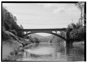
Baker River upstream of Baker Lake
|
|

Map of the Baker River watershed
|
|
| Country | United States |
| State | Washington |
| County | Skagit, Whatcom |
| Physical characteristics | |
| Main source | Cascade Range Whatcom Peak, Whatcom County 5,800 ft (1,800 m) 48°51′1″N 121°22′52″W / 48.85028°N 121.38111°W |
| River mouth | Skagit River Concrete, Skagit County 820 ft (250 m) 48°45′54″N 121°32′34″W / 48.76500°N 121.54278°W |
| Length | 30 mi (48 km) |
| Basin features | |
| Basin size | 297 sq mi (770 km2) |
The Baker River is a river about 30 miles (48 km) long. It flows south into the Skagit River in northwestern Washington State, USA. It collects water from the tall North Cascades mountains. This area is part of the larger Puget Sound watershed, located north of Seattle and east of Mount Baker.
The river's watershed covers about 270 square miles (700 km²). Some of this area is inside North Cascades National Park. The Baker River is the last big river that flows into the Skagit River before the Skagit reaches Skagit Bay. The Baker River flows through the town of Concrete, Washington near where it joins the Skagit. It also has two dams that create electricity, owned by Puget Sound Energy.
Contents
Where the Baker River Flows
The Baker River starts high up in the Cascade Range mountains. Its source is near Whatcom Peak, which is in the northern part of North Cascades National Park. From there, it flows south through the Baker River Valley, northeast of Mount Shuksan.
The river generally flows southwest through a steep valley carved by glaciers. Many smaller streams fed by glaciers join the Baker River. Some of these streams have very tall waterfalls, though their exact heights have never been officially measured.
Lakes and Dams
Most of the southern part of the river flows through two artificial lakes. These lakes are part of the Baker River Hydroelectric Project, which uses the river's power to make electricity.
The first lake is Baker Lake, which is about 9 miles (14 km) long. This lake was naturally there before, but its water level was raised by the Upper Baker Dam. This dam is 312 feet (95 meters) tall.
Right below Baker Lake is Lake Shannon. This lake is created by the Lower Baker Dam and stretches about 7.5 miles (12 km) downstream. After the Lower Baker Dam, the Baker River flows freely for about a mile. Then, it empties into the Skagit River.
Most of Baker Lake is located within the Mount Baker-Snoqualmie National Forest. The Upper Baker Dam is in Whatcom County, Washington, and the Lower Baker Dam is in Skagit County, Washington, just above the town of Concrete, Washington. Both dams are owned by Puget Sound Energy.
Amazing Salmon of the Baker River
The Baker River is very important for a special type of fish called Sockeye salmon. These sockeye are the only known group of their kind that live in the entire Skagit River area. Scientists from the Washington Department of Fish and Wildlife (WDFW) have found that Baker River sockeye are genetically different from other sockeye salmon.
Protecting the Sockeye
In the past, the number of sockeye salmon in the Baker River became very low. In 1985, only 92 adult fish returned to the river. This was a "critical" situation. However, since the 1990s, the sockeye population has gotten much better. This is partly because of improvements in how young fish (smolts) are caught and moved.
For example, in 2003, over 20,000 fish were counted. Since 2010, the numbers have been between 10,000 and 30,000 fish each year. Experts even predicted that about 46,000 Baker sockeye would return in 2015!
How Dams Affect Salmon
Before the Lower Baker Dam was built in 1925, salmon could swim freely up the river to the natural Baker Lake. About 20,000 sockeye salmon used to return each year.
People started trying to help the salmon in 1896. The State of Washington built a hatchery on Baker Lake to help sockeye eggs hatch. This was the first place ever built to hatch sockeye salmon. The hatchery closed in 1933.
When the Upper Baker Dam was built in 1959, it flooded the original Baker Lake and the surrounding valley. This included the natural places where the Baker River sockeye used to lay their eggs. To help, new artificial spawning beds were built at the upper end of the new Baker Lake. Another special spawning beach was added on Sulfur Creek in 1990. Today, all sockeye salmon that return to the river are caught below the Lower Baker Dam and then moved to these artificial spawning beaches.
Other Fish in the River
The Baker River is also home to other types of salmon and trout. These include:
- Coho salmon
- Chinook salmon
- Pink salmon
- Chum salmon
- Winter and summer steelhead trout
- Sea-run cutthroat trout
Streams Joining the Baker River

Many smaller streams flow into the Baker River. Here is a list of some of them, starting from the mouth of the river and moving upstream. (L means it joins from the left bank, and R means it joins from the right bank as you look downstream):
- Thunder Creek (L)
- Bear Creek
- Rocky Creek (R)
- Sulphur Creek (R)
- Anderson Creek
- Sandy Creek (R)
- Park Creek (R)
- Swift Creek (R)
- Morovitz Creek
- Shannon Creek (R)
- Shuksan Lake Creek (R)
- Blum Creek (L)
- Sulphide Creek (R)
- Bald Eagle Creek
- Pass Creek
- Picket Creek (L)
- Mineral Creek
