Scotia Bluffs facts for kids
Quick facts for kids Scotia Bluffs |
|
|---|---|

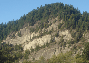
Upper portion of Scotia Bluffs viewed from Rio Dell
|
|
| Highest point | |
| Prominence | 550 ft (170 m) |
| Geography | |
| Location | Humboldt County, California |
| Topo map | USGS Hydesville |
Scotia Bluffs are a series of gray sandstone cliffs. They stretch for about 2 miles (3 kilometers) along the north side of the Eel River. You can find them near Rio Dell, California.
Contents
What are Scotia Bluffs?
The Scotia Bluffs are tall, rocky cliffs made of sandstone. They stand proudly along the Eel River. These bluffs are a natural landmark in Humboldt County, California.
How were the Scotia Bluffs formed?
The lower part of the Eel River usually flows northeast. But when it reaches the Scotia Bluffs, it turns west. This happens because the bluffs are made of very strong rock. This rock is a type of sandstone from the Pliocene time period. It contains many fossils.
The river's strong currents have carved deep pools at the base of these cliffs. Smaller streams, like Nanning Creek, have also cut narrow canyons through the bluffs. On the opposite side of the river, there's a flat area called an alluvial plain. The town of Rio Dell is located on this flat land, right across from the cliffs.
What can you find in the bluffs?
The rocks of Scotia Bluffs are like a window into the past. They hold many fossils of ancient sea creatures. You can often see remains of old clams and sand dollars embedded in the sandstone. These fossils show that the area was once covered by the ocean.
History of the Scotia Bluffs
The Scotia Bluffs have played an important role in local transportation.
Railroad construction along the bluffs
Between 1883 and 1885, the Pacific Lumber Company built a railroad line right across the face of the bluffs. This railway was used to carry lumber to Eureka, California. Later, the Northwestern Pacific Railroad used this same route. It helped them avoid building a bridge over the lower Eel River.
The railway was built about 50 feet (16 meters) above the river's low summer water level. The cliffs themselves rise much higher, from 75 to 500 feet (25–150 meters) above the tracks. To keep the railway safe, workers built many benches, retaining walls, and wooden bridges called trestles.
Challenges for the railroad
The railway along Scotia Bluffs faced many problems. Floods and large rocks falling from the cliffs often damaged the tracks and trestles. Train service was stopped many times due to these issues. Some of these interruptions happened in 1907, 1913, 1933, 1938, 1942, 1946, 1955, 1956, 1957, 1964, and 1971.
From 1916 to 1959, a special railroad crew worked only on the Scotia Bluff trestles. They were always repairing the damage. In 1955, floodwaters reached the track level. In 1964, the water was 11 feet (3.3 meters) above the railway! Sadly, on January 17, 1953, a landslide from the bluffs swept a train engine into the river. Three trainmen lost their lives in this accident.

