
Seal Rocks (San Francisco, California) facts for kids

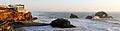
The Seal Rock and Cliff House.
|
|

Seal Rocks
Location in San Francisco

Seal Rocks
Location in San Francisco Bay Area

Seal Rocks
Location in California

Seal Rocks
Location in the United States
|
|
| Geography | |
|---|---|
| Location | Northern California |
| Coordinates | 37°46′42″N 122°30′59″W / 37.77826°N 122.51636°W |
| Adjacent bodies of water | Pacific Ocean |
| Administration | |
| State | |
| County | San Francisco |
| City | San Francisco |


Seal Rock is a group of small rock islands located in the Lands End area of western San Francisco, California. These islands are just off the coast in the Pacific Ocean. You can find them at the northern end of Ocean Beach, close to the famous Cliff House and the old Sutro Baths ruins.
The name "Seal Rock" comes from the many sea lions that rest on these rocks. You'll often see both Steller's sea lions and California sea lions there. Even though they are sea lions, people often call them "seals." These rock formations and the animals living on them are protected as part of the Golden Gate National Recreation Area.
Contents
What are the Seal Rocks?
Seal Rocks are a collection of natural rock formations. They are located very close to the shore of San Francisco. These rocks are a popular spot for sea lions to gather and relax.
Where are the Seal Rocks located?
The Seal Rocks are found in the Pacific Ocean. They are just off the coast of the Outer Richmond District in San Francisco. This area is known as Lands End.
What animals live on Seal Rocks?
The main animals you will see on Seal Rocks are sea lions. Both Steller's sea lions and California sea lions use the rocks. They come ashore to rest, warm up, and socialize. These animals are protected by law.
How did Seal Rocks form?
The landscape around Seal Rocks has changed a lot over time. Near the end of the last ice age, the coastline was much further west. It was about eight to twenty-five miles away from where it is today. About 5,000 years ago, the ice melted. This caused the sea level to rise to its current height.
How waves and wind shaped the coast
The coastal features we see today were created by nature. Waves, wind, and sand movement all played a part. The San Francisco coastline here has steep rocky cliffs. There are also small sandy beaches at the city's north end. Longer sandy areas are found at Ocean Beach and Fort Funston to the south.
The geology of the San Francisco Peninsula
The local features, including the entire San Francisco Peninsula, come from the northern part of the Santa Cruz Mountains. Before cities were built, the land behind Ocean Beach was mostly sand fields. These stretched inland towards Twin Peaks. The first map of this area was made in 1852. It showed the coastline as completely natural, with no human changes.
Layers of earth beneath Ocean Beach
The ground under Ocean Beach has several layers. Starting from the top (the newest layer), they are:
- Placed fill: This is material added by humans. It comes from various building projects over the last 100 years. In 1985, this layer was estimated to be about 7 to 16 feet deep.
- Dune sands: These are layers of sand from old dunes. They are estimated to be 13 to 26 feet deep.
- Colma Formation: This is a geological layer found under the dune sands. It also extends further inland.
- Merced Formation: Another geological layer beneath the Colma Formation.
- Bedrock: This is the solid rock layer deep underground. It is estimated to be about 350 to 400 feet deep.
The Colma and Merced Formations are mostly sandy. They were likely formed when sea levels were higher in the past.
Images for kids
-
The Seal Rock and Cliff House.
