Twin Peaks (San Francisco) facts for kids
Quick facts for kids Twin Peaks |
|
|---|---|

The Twin Peaks
|
|
| Type | Municipal (San Francisco) |
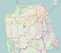
| Location | San Francisco |
| Area | 34 acres (14 ha) |
| Operated by | San Francisco Recreation & Parks |
| Status | Open all year |
| Highest point | |
| Elevation | 925 ft (282 m) NAVD 88 |
| Listing | San Francisco Hill |
| Geography | |
| Location | San Francisco, California, U.S. |
| Topo map | USGS San Francisco North |
| Climbing | |
| Easiest route | Paved road, hike |
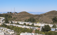
The Twin Peaks are two famous hills in San Francisco, California. They stand about 925 feet (282 meters) tall. These peaks are almost in the very center of the city. They are the second and third highest natural spots in San Francisco. Only Mount Davidson, which is a little taller at 928 feet (283 meters), is higher.
Contents
Discovering Twin Peaks: Location and Weather
Twin Peaks, along with Mount Davidson and Mount Sutro, create a unique landscape in San Francisco. These hills actually help shape the weather in different parts of the city. They act like a natural wall, blocking the summer fog from reaching the eastern neighborhoods.
How Twin Peaks Affects San Francisco's Weather
The North and South Twin Peaks are also known as "Eureka" and "Noe." They are about 200 meters (656 feet) apart. These peaks divide the summer fog that rolls in from the Pacific Ocean. The sides of the peaks facing west often get lots of fog and strong winds. But the east-facing slopes usually get more sunshine and feel warmer. Both peaks are just over 900 feet (274 meters) high. The soil on Twin Peaks is thin and sandy, which means it can easily wear away.
When Snow Falls on Twin Peaks
It's very rare, but sometimes Twin Peaks gets a light covering of snow. For example, on February 5, 1976, several inches of snow fell on the peaks.
A Look Back: The History of Twin Peaks
Early Days: Native People and Spanish Explorers
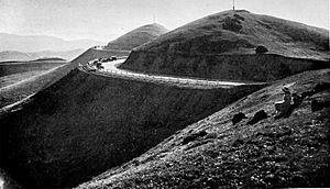
Long ago, before Europeans arrived, the native Ohlone people might have used Twin Peaks. They may have used it as a high spot to look out or to hunt for food. When Spanish explorers and settlers came in the early 1700s, they called the area "Los Pechos de la Chola." This means "Breasts of the Indian Maiden." They used the land for raising animals.
Changing Names: From Spanish to American Control
In the 1800s, San Francisco became part of America. That's when the area was renamed "Twin Peaks."
Modern Changes: Making Twin Peaks Friendly for Everyone
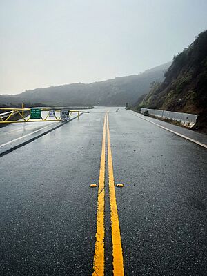
In 2016, the SFMTA started a project to make the summit area better. They wanted to reduce space for cars and make it more welcoming for people walking and biking. The "figure 8" road around the peaks was changed. Now, the western side is a two-way road for cars. The eastern side is only for people walking and riding bikes. Construction began in 2025 to rebuild the east side into a wide walking path. This followed improvements to the Noe Peak trail and the path down to Crestline Drive.
What to See: Attractions at Twin Peaks
Twin Peaks offers amazing views and is home to important natural areas.
Christmas Tree Point: A View from the Top
Christmas Tree Point is a great spot for views of San Francisco and San Francisco Bay. It's about 70 feet (21 meters) below the North Peak. On a clear day, you can see far to the north, all the way to Cobb Mountain, which is about 120 kilometers (75 miles) away. If you look southeast down the Santa Clara Valley, you might even spot Santa Ana Mountain, about 143 kilometers (89 miles) away.
Water for Firefighters: A Special Reservoir
To the north of Twin Peaks, there is a special reservoir. The San Francisco Fire Department owns it. This reservoir provides water to the Fire Department's special water system for fighting fires. This system was created after the big 1906 earthquake and fire.
Twin Peaks Natural Area: Home to Wildlife
The very top of Twin Peaks is kept natural and undeveloped. It's part of the 31-acre (12.5-hectare) Twin Peaks Natural Area. The San Francisco Recreation and Parks Department manages this area. These preserved lands are important for many plants and animals. Twin Peaks is one of the last places where the endangered Mission blue butterfly lives. Many different kinds of birds, insects, and plants also thrive here.
Underground Travel: The Twin Peaks Tunnel
The Muni Metro Twin Peaks Tunnel runs right under Twin Peaks. This tunnel connects downtown San Francisco with West Portal and the southwestern part of the city. While there's no public transport directly to the very top of the peaks, the 37 Corbett Muni bus line stops on Crestline Drive. From there, you can take a path up the hill.
The name "Twin Peaks" is also used for the neighborhood around the hills.
Learning in the Neighborhood: Education
The San Francisco Unified School District operates the Ruth Asawa San Francisco School of the Arts in the Twin Peaks neighborhood. The closest SFUSD school to the top of Twin Peaks is Rooftop.
See also
- 49-Mile Scenic Drive
- List of hills in San Francisco
- Twin Peaks Tunnel
 | Isaac Myers |
 | D. Hamilton Jackson |
 | A. Philip Randolph |


