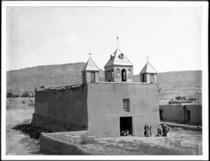
Seboyeta, New Mexico facts for kids
Quick facts for kids
Seboyeta, New Mexico
|
|
|---|---|

Exterior view of a church at Cibolleta, New Mexico, ca.1898
|
|
| Country | United States |
| State | New Mexico |
| County | Cibola |
| Area | |
| • Total | 2.67 sq mi (6.92 km2) |
| • Land | 2.67 sq mi (6.92 km2) |
| • Water | 0.00 sq mi (0.00 km2) |
| Elevation | 6,362 ft (1,939 m) |
| Population
(2020)
|
|
| • Total | 164 |
| • Density | 61.38/sq mi (23.70/km2) |
| Time zone | UTC-7 (Mountain (MST)) |
| • Summer (DST) | UTC-6 (MDT) |
| ZIP code |
87014
|
| Area code(s) | 505 |
| GNIS feature ID | 2584216 |
Seboyeta is a small community in Cibola County, New Mexico, in the United States. It is called a "census-designated place" because it is a special area defined for counting people. In 2010, about 179 people lived there. Seboyeta also had its own post office for over 100 years, from 1885 to 1995.
Contents
History of Seboyeta
In 1746, a priest named Padre Juan Menchero convinced many people from the Navajo Tribe to live in a place called Cebolleta. A special church mission was started there to teach the Navajo about Christianity. The community officially began in 1749. It was named "Cebolleta," which means "little onion," after the nearby Cebolleta Mountains (now called the San Mateo Mountains). However, in 1750, the Navajo decided not to stay and returned to their own lands.
Spanish Colonists Arrive
On January 23, 1800, Governor Fernando Chacon approved a request from Francisco Aragon and 29 other people. They wanted to settle at Cebolleta and create a town there. Governor Chacon ordered Jose Manuel Aragon, an "Alcalde" (a type of mayor or judge appointed by the Spanish king) from the Pueblo of Laguna, to officially give the land to these new settlers. Since New Mexico was controlled by Spain at the time, this order was like a royal command.
The colonists were given land with clear borders:
- To the north: the San Mateo Mountains
- To the east: the Zia Road and Pedro Padilla Valley
- To the south: the Mesa del Bagilan, next to the Paquate ranch
- To the west: the San Mateo Mountains
Conflicts and Agreements
In 1801, the Navajo people came back. They believed the land was theirs and forced the colonists to leave. The settlers fled to Chihuahua, which was part of New Spain then.
However, in 1803, the Spanish government made the colonists return to Cebolleta. They were told they would face serious punishment if they left again. This was because they had accepted land from the Spanish king and were not allowed to abandon it.
In 1805, the Navajo attacked the settlement again. This attack could have been very bad, but the Laguna Tribe came to help the colonists. To show their thanks, the people of Cebolleta agreed that the Laguna Tribe owned certain lands to the south, known as the Rancho de Paquate. The colonists had thought this land was theirs before. To make things fair, the Laguna Tribe agreed to buy the houses, barns, and other improvements the colonists had made on these lands. In 1826, after New Mexico became part of the new country of Mexico (instead of Spain), Governor Antonio Narbona officially approved this agreement with a land grant to the Laguna Pueblo.
Under United States Control
In 1846, the United States took control of New Mexico. A military base was set up at Cebolleta in 1849. But in 1862, General Edward Canby ordered this base to move to San Rafael, New Mexico. It was then renamed Fort Wingate.
In 1859, the families who had originally received the Spanish land grant asked the United States government to officially recognize their claim to the land. The Surveyor General, William Pelham, agreed with their request. However, the Congress needed to approve it formally. The start of the Civil War delayed this process until 1869. A formal document, called a "patent," approving their land claim was finally issued on January 27, 1882.
In 1885, a post office was opened for the town. There were already several places named "Cebolleta" in the Post Office directory. So, the different spelling, Seboyeta, was used instead.
Population Information
Seboyeta's Demographics
A "census" is like a big count of all the people living in an area. It helps us understand how many people live in a place and how the population changes over time.
| Historical population | |||
|---|---|---|---|
| Census | Pop. | %± | |
| 2020 | 164 | — | |
| U.S. Decennial Census | |||
According to the 2020 United States Census, Seboyeta had a population of 164 people.
See also
 In Spanish: Seboyeta (Nuevo México) para niños
 | Misty Copeland |
 | Raven Wilkinson |
 | Debra Austin |
 | Aesha Ash |


