Seltannasaggart facts for kids
Quick facts for kids Seltannasaggart |
|
|---|---|
| Sailtean na Sagart Corry Mountain |
|

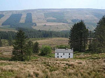
Seltannasaggart from the southwest
|
|
| Highest point | |
| Elevation | 428 m (1,404 ft) |
| Prominence | 137 m (449 ft) |
| Listing | County Top (Roscommon) |
| Naming | |
| English translation | willow plantation of the priests |
| Language of name | Irish |
| Geography | |
| Parent range | Arigna Mountains |
| OSI/OSNI grid | G908142 |
Seltannasaggart (which means "willow plantation of the priests" in Irish), also known as Corry Mountain, is a small mountain in Ireland. It is located near Lough Allen, right on the border between County Roscommon and County Leitrim. This mountain is special because it is the highest point in County Roscommon.
Mountain Location and Height
Seltannasaggart is the tallest point in County Roscommon. It is part of a group of mountains called the Arigna Mountains. The mountain reaches a height of 428 meters (about 1,404 feet) above sea level.
On the southern side of the mountain, you can find some old remains. These include what's left of a promontory fort, which was a type of ancient settlement built on a high piece of land. There are also signs of old sweat houses, which were used for steam baths long ago.
Reaching the Summit
Getting to the top of Seltannasaggart is quite easy. There is a wind farm on the summit, which means you'll see large wind turbines. There is also a quarry nearby, where rocks are dug out of the ground.
A walking path called the Miners Way goes right over the mountain. This trail is popular with hikers and offers great views of the area.
See also
 In Spanish: Sailtean na Sagart para niños
 | Aurelia Browder |
 | Nannie Helen Burroughs |
 | Michelle Alexander |


