Seven Corners, Virginia facts for kids
Quick facts for kids
Seven Corners, Virginia
|
|
|---|---|
|
Census-designated place (CDP)
|
|

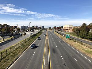
View west along Arlington Boulevard in Seven Corners
|
|

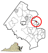
Location of Seven Corners in Fairfax County, Virginia
|
|
| Country | |
| State | |
| County | |
| Area | |
| • Total | 0.7 sq mi (1.8 km2) |
| • Land | 0.7 sq mi (1.8 km2) |
| • Water | 0.0 sq mi (0.0 km2) |
| Elevation | 384 ft (117 m) |
| Population
(2020)
|
|
| • Total | 9,131 |
| • Density | 13,000/sq mi (5,070/km2) |
| Time zone | UTC−5 (Eastern (EST)) |
| • Summer (DST) | UTC−4 (EDT) |
| ZIP code |
22044
|
| Area code(s) | 571, 703 |
| FIPS code | 51-71216 |
| GNIS feature ID | 1493537 |
Seven Corners is a busy area in Fairfax County, Virginia, United States. It's a "census-designated place" (CDP), which means it's a community that the government counts for population, but it's not an official city or town. In 2020, about 9,131 people lived there.
Even though Seven Corners has a "Falls Church" mailing address, it's not actually inside the city of Falls Church. The area gets its unique name from a very old and busy intersection. This intersection used to have seven "corners" where different roads met. These roads include State Route 7, U.S. Route 50, State Route 613, State Route 338, and Wilson Boulevard.
Contents
Exploring Seven Corners' Geography
Seven Corners is a small area, covering about 0.7 square miles (1.8 square kilometers) of land. There's no water area within its borders. A small stream called Upper Long Branch flows through the lowest part of the area.
The community is built on a place called Munson's Hill. From here, you can see great views towards the south and west. These views look out over nearby areas like Annandale and Fairfax City.
The History of Seven Corners
Before the 1950s, Seven Corners was known by a different name: Fort Buffalo. This name came from a fort built during the American Civil War. In October 1862, soldiers from the 21st New York Infantry built Fort Buffalo. It was located on the south side of Leesburg Pike, where it now meets Sleepy Hollow Road.
The fort was built in this spot because it offered excellent views to the east and south. This allowed soldiers to watch for Confederate Army troops who might be approaching. After the war, the large fort was taken apart. However, some of the earthworks (parts of the fort made from earth) could still be seen even in the 1930s.
The name of the area changed in the 1950s. This happened because a new road, Lee Memorial Boulevard (now Arlington Boulevard or U.S. Route 50), was built. The construction of Route 50 created the famous "seven cornered" intersection. Over time, Wilson Boulevard was slightly moved to make the intersection less confusing.
With the new Route 50, Seven Corners quickly grew into an important shopping area. The Seven Corners Shopping Center opened in 1956. It was one of the first large shopping malls in the Washington, D.C. area. Route 50 was originally planned as a scenic road connecting Washington, D.C., to the Shenandoah Valley. Today, it's a busy commercial road, and Interstate 66 now serves as the main link to the valley.
Who Lives in Seven Corners?
| Historical population | |||
|---|---|---|---|
| Census | Pop. | %± | |
| 1970 | 5,590 | — | |
| 1980 | 6,058 | 8.4% | |
| 1990 | 7,280 | 20.2% | |
| 2000 | 8,701 | 19.5% | |
| 2010 | 9,255 | 6.4% | |
| 2020 | 9,131 | −1.3% | |
| source: | |||
In 2000, there were 8,701 people living in Seven Corners. The community had 3,304 households. About 28.8% of these households had children under 18 living with them. Many different groups of people live in Seven Corners, making it a diverse place.
The population is spread out in terms of age. About 21.2% of residents were under 18 years old. The median age was 32 years, meaning half the people were younger than 32 and half were older.
Important Places in Seven Corners
Seven Corners is home to several well-known spots:
- The Seven Corners Shopping Center is a major shopping area.
- The Eden Center is a Vietnamese-American shopping center. It's located very close to Seven Corners Shopping Center, just outside the CDP in Falls Church.
- The Dar Al-Hijrah mosque is also located in Seven Corners.
- In 2002, a sad event happened at the Home Depot parking garage in the Seven Corners Shopping Center. It was the scene of one of the incidents during the Beltway sniper attacks.
Managing Traffic at the Intersection
The famous "seven corners" intersection has changed over time. It no longer has exactly seven corners. Instead, it has been redesigned with several intersections that are easier for drivers to use. Drivers going in any direction will encounter traffic lights. There is also a special bridge for people to walk over US 50, making it safer for pedestrians. However, the roads themselves are not very friendly for walking.
Fairfax County has a plan to manage traffic and develop the area. Work has already started, and the county now owns much of the land between Leesburg Pike and Wilson Boulevard, near Patrick Henry Drive.
Here's a simple way to understand how traffic works on the main roads:
- US Route 50 (US 50): This is a highway that runs east to west. It has smaller "frontage roads" that connect to other roads at the intersection. Cars traveling long distances can stay on the main highway without stopping for local traffic.
- State Road 7 (SR 7): This road has four to six lanes and is divided by a median. It follows East Broad Street to the northwest and Leesburg Pike to the southeast. Drivers can use this road to get to any of the other roads.
- State Road 338 (SR 338): This road ends at the intersection from the northwest. If you're going southeast on SR 338, you will automatically merge onto SR 7 heading east.
- Sleepy Hollow Road: This road ends at the intersection. If you're going north on Sleepy Hollow, you will automatically merge onto SR 7 heading southeast. Secondary State Route 613 follows Sleepy Hollow to the south and continues along Wilson Boulevard to the northeast.
- Wilson Boulevard: This road ends at the intersection from the northeast. If you're going south on Wilson Boulevard, you will automatically merge onto the US 50 frontage road heading northwest. From this frontage road, you can then access all the other roads at the intersection.
See also
 In Spanish: Seven Corners (Virginia) para niños
 | May Edward Chinn |
 | Rebecca Cole |
 | Alexa Canady |
 | Dorothy Lavinia Brown |


