Severn River (Maryland) facts for kids
Quick facts for kids Severn River |
|
|---|---|

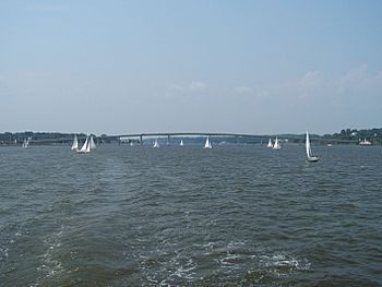
Severn River with the Naval Academy Bridge in the distance
|
|
| Country | United States |
| State | Maryland |
| Cities | Annapolis, Arnold, Severna Park, Crownsville, Millersville |
| Physical characteristics | |
| Main source | Severn, Maryland |
| River mouth | Chesapeake Bay 0 ft (0 m) |
| Basin features | |
| Tributaries |
|
The Severn River is a special kind of river called a tidal estuary. This means its water level changes with the ocean tides. It is about 14 miles (22.5 km) long. You can find it in Anne Arundel County, Maryland, in the United States. It's located between the Magothy River to the north and the South River to the south.
Contents
Exploring the Severn River
The Severn River has a total watershed area of about 81 square miles (210 km²). A watershed is the land area that drains water into a river or lake. For the Severn, about 15% of this area is water itself.
Where the River Starts and Ends
The Severn River begins as a non-tidal stream called Severn Run. This stream is about nine miles long. It starts in the northwestern part of Anne Arundel County, in a town also called Severn.
The river then flows into the Chesapeake Bay. This happens near the important city of Annapolis. Annapolis is not only a major port but also the capital city of Maryland.
Fun on the River
The Severn River is very popular for many activities. It provides easy access to the Chesapeake Bay. People from the United States Naval Academy use it for training. It's also a favorite spot for fishermen and people who enjoy boating.
Several smaller streams, called tributaries, flow into the Severn River. These streams drain water from developed areas. For example, Weems Creek and its part called Cowhide Branch collect water from places like the Annapolis Mall and the Anne Arundel Medical Center.
Bridges Over the Severn
Two main bridges cross the Severn River.
- One bridge is known as the Severn River Bridge. It is also called the Pearl Harbor Memorial Bridge. This bridge carries major roads like US 50, US 301, and MD 2. The first version of this bridge was built way back in 1886.
- The other bridge carries MD 450. It is officially named the "US Naval Academy Bridge". This is because its southern end is right next to the Naval Academy. This bridge was first built as a drawbridge in the late 1920s. It was replaced with the taller bridge you see today in 1994.
There used to be an old railroad bridge between these two bridges. It was built around 1887 for a railroad line. However, it was removed after 1968 because it was no longer safe.
Communities by the River
On the north side of the river, across from Annapolis, you'll find communities like St. Margaret's. This area is next to the historic colonial plantation called Whitehall.
Streams that Feed the Severn
Many smaller streams, called tributaries, flow into the Severn River. They are listed below, starting from the upper river and moving downstream. Some tributaries even have their own smaller streams that feed into them.
North Shore Tributaries
- Pointfield Branch
- Bear Branch
- Cold Spring Branch (also known as Cool Spring Branch)
- Chartwell Branch
- Stevens Creek & Lake Liberty
- Rock Cove
- Forked Creek & Sacketts Pond
- Yantz Creek (or Yantz Cove) & Cedar Creek
- Sullivan Cove
- Ringgold Cove
- Asquith Creek (or Aisquith Creek)
- Rays Pond
- Chase Creek (or Timberneck Creek)
- Cool Spring Cove (or Creek)
- Winchester Pond (or Crouchs Pond)
- Manresa Pond (or Browns Cove or Pond)
- Woolchurch Cove & Pond
- Carr Creek
South Shore Tributaries
- Sewell Spring Branch
- Indian Creek & Indian Creek Branch
- Cypress Branch
- Arden Pond
- Plum Creek & Gumbottom Branch
- Valentine Creek
- Old Place Creek (or Fox Creek)
- Browns Cove (on Little Round Bay)
- Maynadier Creek & Deep Ditch Branch
- Hopkins Creek & Davids Run
- Brewer Pond & Arthurs Run
- Brewer Creek & Howards Branch
- Clements Creek & Hockley Branch
- Saltworks Creek & Cabin Branch
- Martins Pond (or Whitehurst Lake)
- Luce Creek & Howard Creek
- Cove of Cork
- Weems Creek & Cowhide Branch
- Shady Lake
- College Creek (or Dorsey Creek) & Peters Cove
- Spa Creek (or Spaw Creek, Carrols Creek) & Acton Cove, Hawkins Cove
- Lake Ogelton
- Back Creek
The Lost Town of Providence
Providence was the very first colonial settlement in Anne Arundel County. It was founded in 1649–1650. A group of Puritans and other settlers moved there from Virginia. They mostly settled on the north side of the Severn River's mouth.
However, Providence slowly disappeared after the 1680s. This happened because Annapolis became more important. In 1694, Annapolis was even made the capital of Maryland.
For a long time, people thought this "lost town" of Providence was only in the Carr Creek and Greenbury Point area. This area is now part of Naval Station Annapolis. But newer archaeological research has found homes from this spread-out settlement further north and northeast. These discoveries were made on the southern part of the Broadneck Peninsula, especially near Whitehall Creek.
 | Laphonza Butler |
 | Daisy Bates |
 | Elizabeth Piper Ensley |

