Sgùrr a' Bhealaich Dheirg facts for kids
Quick facts for kids Sgùrr a' Bhealaich Dheirg |
|
|---|---|

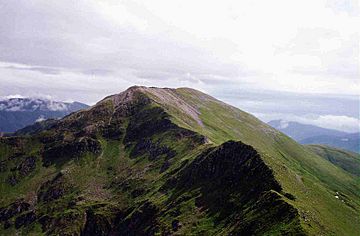
Sgùrr a' Bhealaich Dheirg seen from Sàileag 2 km to the W.
|
|
| Highest point | |
| Elevation | 1,036 m (3,399 ft) |
| Prominence | 311 m (1,020 ft) |
| Listing | Munro, Marilyn |
| Naming | |
| English translation | Peak of the Red Pass |
| Language of name | Gaelic |
| Geography | |
| Location | Kintail, Scotland |
| Parent range | Northwest Highlands |
| OS grid | NH035143 |
| Topo map | OS Landranger 33, OS Explorer 414 |
Sgùrr a' Bhealaich Dheirg is a tall mountain in Scotland. It is found in a beautiful area called Kintail. This mountain is on the northern side of Glen Shiel. It is about 30 kilometres (19 miles) south-east of Kyle of Lochalsh.
Sgùrr a' Bhealaich Dheirg is a special kind of Scottish mountain called a Munro. A Munro is a mountain in Scotland that is over 3,000 feet (914.4 metres) high.
Contents
Meet the Brothers of Kintail
Sgùrr a' Bhealaich Dheirg is part of a famous group of three Munros. These mountains are known as the North Glen Shiel Ridge. The other two mountains in this group are Aonach Meadhoin and Sàileag. Together, they are often called the “Brothers of Kintail”. This name helps tell them apart from another nearby group. That other group is the Five Sisters of Kintail, which are just to the west.
Sgùrr a' Bhealaich Dheirg is the tallest of the three Brothers. It stands at 1,036 metres (3,399 feet) high. Its name comes from the Gaelic words meaning “Peak of the Red Pass”. However, the exact location of this "Red Pass" is not clearly marked on maps.
What Does the Mountain Look Like?
Sgùrr a' Bhealaich Dheirg has very steep, grassy slopes on its southern side. These slopes drop down into Glen Shiel. On the northern side, you will find rocky, bowl-shaped valleys called coires and sharp ridges. The southern side of the mountain drops about 850 metres (2,789 feet) over two kilometres. Because it is so steep, most people do not climb the mountain directly from the A87 road in the glen.
The mountain has four main ridges. A long ridge runs from east to west. This ridge connects Sgùrr a' Bhealaich Dheirg to its neighbouring Munros, Sàileag (to the west) and Aonach Meadhoin (to the east). There are also two ridges that go north from the top of the mountain. These ridges lead into the wild and quiet area of the Kintail Forest.
Where Does the Water Go?
Sgùrr a' Bhealaich Dheirg sits on a very important line in Scotland. This line is called the main east-west watershed. This means that rain falling on one side of the mountain flows to the west coast. Rain falling on the other side flows to the east coast.
Two large rivers start from the northern valleys of this mountain. The River Croe begins from a small lake called Loch a Glas Choire. It flows north-west for 12 kilometres (7.5 miles). It then joins the sea at Loch Duich on Scotland's west coast. The River Affric starts in Coire nan Eun, on the eastern side of the mountain. This river flows for about 80 kilometres (50 miles). It eventually reaches the east coast at the Beauly Firth. The lower southern slopes of the mountain are covered with trees from the Glenshiel Forest.
How to Climb Sgùrr a' Bhealaich Dheirg
Because the southern slopes are so steep, most climbers do not go straight up the mountain from there. One way to climb it is to start about two kilometres (1.2 miles) west of the Cluanie Inn. From there, you can walk through the forest. Then, you climb up a smaller ridge called Meall a’ Charra. This ridge connects to the eastern ridge at a low point (a col) near Aonach Meadhoin.
Most people who reach the top of Sgùrr a' Bhealaich Dheirg do so by walking along the east or west ridges. They usually come from the other "Brothers" Munros. A popular way to climb all three mountains is to start at the Cluanie Inn to the east. Or, you can start from a parking spot in Glen Shiel to the west. This long walk usually starts and finishes in different places.
Reaching the Summit
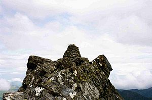
The very top of Sgùrr a' Bhealaich Dheirg can be a bit of a surprise. The highest point is not on the main flat area at the top. Instead, it is about 80 metres (260 feet) along the narrow north-east ridge. There is a strange dry stone wall leading to it. It is an easy climb to reach the well-built stone pile, called a cairn, at the summit. From the top, you get amazing views of the mountains to the north.
 | William L. Dawson |
 | W. E. B. Du Bois |
 | Harry Belafonte |


