Shackelford, California facts for kids
Quick facts for kids
Shackelford
|
|
|---|---|
| Nickname(s):
Little Mexico
|
|

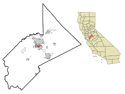
Location in Stanislaus County and the state of California
|
|
| Country | |
| State | |
| County | Stanislaus |
| City | Modesto |
| Area | |
| • Total | 0.682 sq mi (1.765 km2) |
| • Land | 0.672 sq mi (1.739 km2) |
| • Water | 0.010 sq mi (0.026 km2) 1.47% |
| Elevation | 85 ft (26 m) |
| Population
(2010)
|
|
| • Total | 3,371 |
| • Density | 4,943/sq mi (1,909.9/km2) |
| Time zone | UTC-8 (Pacific (PST)) |
| • Summer (DST) | UTC-7 (PDT) |
| ZIP code |
95351
|
| Area code(s) | 209 |
| FIPS code | 06-71084 |
| GNIS feature ID | 1853416 |
Shackelford is a neighbourhood located south of Modesto in Stanislaus County, California. It officially became part of Modesto on June 1, 2012. In 2010, about 3,371 people lived there. This was a decrease from 5,170 people in 2000. Shackelford is part of the larger Modesto area. Before it joined Modesto, it was known as a census-designated place (CDP). A CDP is a special area that the government counts for population, but it is not an official city.
History of Shackelford
Early Development and Infrastructure
In 1916, an important structure called the Lion Bridge was built. This bridge crosses the Tuolumne River. It helped people travel more easily between the cities of Modesto and Ceres. Building the bridge cost $111,000 at that time.
Becoming Part of Modesto
The city of Modesto worked for many years to include Shackelford. This effort finally ended in 2012 when Modesto officially took over the "Shackelford annexation area." This means Shackelford became a formal part of the city. The area is surrounded by California State Route 99 to the north, Crows Landing Road to the west, Main Street to the east, and Hatch Road to the south.
Geography of Shackelford
Where is Shackelford Located?
Shackelford is found in the southern part of Modesto. Its exact location is 37°36′54″N 120°59′27″W / 37.61500°N 120.99083°W. This is a set of numbers that helps pinpoint its spot on a map.
Land and Water Area
According to information from the United States Census Bureau, Shackelford covers a total area of about 0.7 square miles (1.76 square kilometers). Most of this area is land. Only a small part, about 1.47%, is water.
Population and People
Shackelford's Population in 2010
The 2010 United States Census counted the people living in Shackelford. It showed a total population of 3,371. This means there were about 4,945.7 people living in each square mile.
Who Lives in Shackelford?
The census also looked at the different groups of people in Shackelford:
- About 46.3% of the people were White.
- About 0.8% were African American.
- About 1.9% were Native American.
- About 1.8% were Asian.
- A very small number, 0.0%, were Pacific Islander.
- About 44.4% were from other racial backgrounds.
- About 4.9% were from two or more races.
- A large group, about 79.6%, identified as Hispanic or Latino.
All 3,371 people counted lived in homes. No one lived in group homes or institutions at that time.
Households and Families
There were 898 households in Shackelford. A household is a group of people living together in one home.
- 55.6% of households had children under 18.
- 41.9% were married couples.
- 23.9% were homes with a female head and no husband.
- 12.5% were homes with a male head and no wife.
- The average household had 3.75 people.
- There were 703 families, with an average of 4.06 people per family.
Age Groups in Shackelford
The population was made up of different age groups:
- 34.9% were under 18 years old.
- 10.8% were between 18 and 24 years old.
- 29.7% were between 25 and 44 years old.
- 18.1% were between 45 and 64 years old.
- 6.5% were 65 years old or older.
The average age in Shackelford was 27.4 years.
Housing in Shackelford
There were 1,059 housing units in total. A housing unit is a house, apartment, or other place where people live.
- 37.4% of these homes were owned by the people living in them.
- 62.6% of these homes were rented.
- About 38.5% of the people lived in homes they owned.
- About 61.5% of the people lived in rented homes.
Shackelford's Population in 2000
In the year 2000, Shackelford had a population of 5,170 people. This was before it became part of Modesto. The population density was about 6,106.4 people per square mile. There were 1,454 housing units.
Who Lived in Shackelford in 2000?
The racial makeup in 2000 was:
- 50.14% White.
- 1.41% African American.
- 2.13% Native American.
- 0.95% Asian.
- 0.14% Pacific Islander.
- 38.63% from other races.
- 6.62% from two or more races.
- About 68.12% of the population was Hispanic or Latino.
Households and Income in 2000
There were 1,363 households.
- 49.5% of households had children under 18.
- 49.3% were married couples.
- The average household size was 3.79 people.
- The average family size was 4.25 people.
The average income for a household was $23,289 per year. For a family, it was $24,541. The average income per person was $7,250. About 36.1% of the total population lived below the poverty line. This means they had very low incomes.
See also
 In Spanish: Shackelford (California) para niños
 | Leon Lynch |
 | Milton P. Webster |
 | Ferdinand Smith |


