Sheep Mountain (Alaska) facts for kids
Quick facts for kids Sheep Mountain |
|
|---|---|

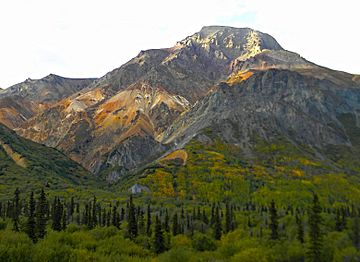
South aspect from Glenn Highway
|
|
| Highest point | |
| Elevation | 6,223 ft (1,897 m) |
| Prominence | 323 ft (98 m) |
| Isolation | 1.6 mi (2.6 km) |
| Parent peak | Gunsight Mountain |
| Geography | |
| Location | Matanuska-Susitna Borough Alaska, United States |
| Parent range | Talkeetna Mountains |
| Topo map | USGS Anchorage D-2 |
Sheep Mountain is a cool mountain peak in Alaska, standing tall at about 6,223 feet (or 1,897 meters) above sea level. It's located about 50 miles (80 kilometers) northeast of a town called Palmer. This mountain is part of the southern Talkeetna Mountains.
You can find Sheep Mountain right in the middle of the journey between Palmer and Glennallen. The main road, called the Glenn Highway, runs right along the southern side of the mountain. It's a famous landmark for people traveling this highway!
Sheep Mountain is pretty close to other peaks too. It's about 1.6 miles (2.6 kilometers) west-southwest of Gunsight Mountain and about 10.75 miles (17.3 kilometers) northeast of Mount Wickersham. The name "Sheep Mountain" was first written down in 1906 by the United States Geological Survey, which is a group that studies the Earth. In the Ahtna language, which is spoken by some Native Alaskans, the mountain is called Beznae. This means "a type of stone."
Climate
Sheep Mountain is in a place with a subarctic climate. This means it has very long, cold, and snowy winters. The summers, however, are usually mild and pleasant.
During the winter, temperatures can drop really low, sometimes even below -20 °C (-4 °F). With the wind chill, it can feel even colder, below -30 °C (-22 °F)! If you want to visit or climb Sheep Mountain, the best time is usually from May through June. The weather during these months is much nicer for outdoor activities.
All the rain and melting snow from the mountain flow into smaller streams. These streams then join up with the Matanuska River.
 | Dorothy Vaughan |
 | Charles Henry Turner |
 | Hildrus Poindexter |
 | Henry Cecil McBay |


