Sheridan, Michigan facts for kids
Quick facts for kids
Sheridan, Michigan
|
|
|---|---|
|
Village
|
|

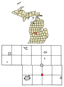
Location in Montcalm County and the state of Michigan
|
|
| Country | United States |
| State | Michigan |
| County | Montcalm |
| Townships | Bushnell, Evergreen, Fairplain, Sidney |
| Area | |
| • Total | 1.16 sq mi (3.00 km2) |
| • Land | 1.10 sq mi (2.85 km2) |
| • Water | 0.06 sq mi (0.15 km2) |
| Elevation | 843 ft (257 m) |
| Population
(2020)
|
|
| • Total | 692 |
| • Density | 628.52/sq mi (242.70/km2) |
| Time zone | UTC-5 (Eastern (EST)) |
| • Summer (DST) | UTC-4 (EDT) |
| ZIP code |
48884
|
| Area code(s) | 989 |
| FIPS code | 26-73100 |
| GNIS feature ID | 2399801 |
Sheridan is a small village located in Montcalm County, in the state of Michigan, United States. In 2020, about 692 people lived there. The village is unique because it sits where four different townships meet. These are Evergreen, Bushnell, Fairplain, and Sidney townships.
History of Sheridan
The story of Sheridan began in 1851. A man named Louis Lovell officially claimed land here. Soon after, John W. Winsor built the very first business, which was a sawmill. This mill helped cut wood into lumber.
Later, in 1864, Erastus P. Brown, who owned a shingle-making mill, became the first postmaster. This meant he was in charge of the local post office. Sheridan also had a train station on the Toledo, Saginaw and Muskegon Railway line. The village officially became a village in 1877. It was named after a famous Union Civil War General, Philip Sheridan.
Geography and Location
Sheridan is found in the southern part of Montcalm County, Michigan. It is located along a state highway called M-66. If you travel north on M-66 for about 6 miles (10 km), you will reach Stanton, which is the main town for the county. Greenville, the biggest city in Montcalm County, is about 11 miles (18 km) to the west-southwest.
The village covers a total area of about 1.16 square miles (3.00 square kilometers). Most of this area, about 1.10 square miles (2.85 square kilometers), is land. The rest, about 0.06 square miles (0.15 square kilometers), is water. A lake called Pearl Lake is located in the western part of the village.
The Sheridan post office uses the ZIP code 48884. This post office serves not only the village itself but also parts of the four surrounding townships. It also reaches into parts of Crystal Township, Bloomer Township, and Montcalm Township.
Population Changes
The population of Sheridan has changed over many years. Here is a look at how many people have lived in the village during different census years:
| Historical population | |||
|---|---|---|---|
| Census | Pop. | %± | |
| 1880 | 661 | — | |
| 1900 | 437 | — | |
| 1910 | 436 | −0.2% | |
| 1920 | 489 | 12.2% | |
| 1930 | 530 | 8.4% | |
| 1940 | 542 | 2.3% | |
| 1950 | 535 | −1.3% | |
| 1960 | 606 | 13.3% | |
| 1970 | 653 | 7.8% | |
| 1980 | 664 | 1.7% | |
| 1990 | 730 | 9.9% | |
| 2000 | 705 | −3.4% | |
| 2010 | 649 | −7.9% | |
| 2020 | 692 | 6.6% | |
| U.S. Decennial Census | |||
In 2010, the village had 649 people living in 277 households. The population density was about 590 people per square mile. By 2020, the population had grown slightly to 692 people.
Village Landmark
Sheridan is known for its historic water tower. This water tower was very important to the village for many years. When the old water tower was taken down, the village decided to honor it. They painted an image of the old water tower on the new one. This shows how much the water tower means to the community.
See also
 In Spanish: Sheridan para niños
 | Jackie Robinson |
 | Jack Johnson |
 | Althea Gibson |
 | Arthur Ashe |
 | Muhammad Ali |

