Fairplain Township, Michigan facts for kids
Quick facts for kids
Fairplain Township, Michigan
|
|
|---|---|
|
Township
|
|
| Country | United States |
| State | Michigan |
| County | Montcalm |
| Area | |
| • Total | 36.0 sq mi (93 km2) |
| • Land | 35.2 sq mi (91 km2) |
| • Water | 0.7 sq mi (2 km2) |
| Elevation | 840 ft (256 m) |
| Population
(2020)
|
|
| • Total | 1,802 |
| • Density | 51.2/sq mi (19.8/km2) |
| Time zone | UTC-5 (Eastern (EST)) |
| • Summer (DST) | UTC-4 (EDT) |
| ZIP codes | |
| FIPS code | 26-117-27180 |
| GNIS feature ID | 1626267 |
Fairplain Township is a civil township located in Montcalm County, in the U.S. state of Michigan. It is a type of local government area. In 2020, about 1,802 people lived in Fairplain Township.
Contents
Communities in Fairplain Township
Fairplain Township is home to a few smaller communities.
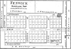
Fenwick: A Historic Spot
One of these is Fenwick. It is an unincorporated community, which means it doesn't have its own separate local government. Fenwick is found in the southeastern part of the township.
Fenwick's Early Days
Fenwick was started in 1872 by a person named B. C. Loree. He named the community after his hometown, Fenwick, Ontario, in Canada. A post office opened in Fenwick on April 28, 1873. James R. Hall was the first postmaster. The community was officially mapped out and recorded on May 22, 1874.
Geography of Fairplain Township
Fairplain Township is located in the southern part of Montcalm County. Its southern border touches Ionia County.
Roads and Waterways
The state highway M-57 runs through the middle of the township. This road goes west to Greenville and east to Carson City.
The township covers a total area of about 36.0 square miles (93.2 square kilometers). Most of this area, about 35.2 square miles (91.2 square kilometers), is land. The rest, about 0.7 square miles (1.8 square kilometers), is water. This means about 2.05% of the township is covered by water.
Local Rivers and Creeks
Most of Fairplain Township is drained by Dickerson Creek. This creek flows into the Flat River. Some small areas on the eastern side of the township drain into Prairie Creek. Both the Flat River and Prairie Creek flow south into the Grand River. The Grand River then flows into Lake Michigan.
Population and People
The number of people living in Fairplain Township has changed over the years.
| Historical population | |||
|---|---|---|---|
| Census | Pop. | %± | |
| 1850 | 229 | — | |
| 1860 | 491 | 114.4% | |
| 1870 | 974 | 98.4% | |
| 1880 | 1,422 | 46.0% | |
| 1890 | 1,131 | −20.5% | |
| 1900 | 1,183 | 4.6% | |
| 1910 | 1,171 | −1.0% | |
| 1920 | 961 | −17.9% | |
| 1930 | 930 | −3.2% | |
| 1940 | 877 | −5.7% | |
| 1950 | 862 | −1.7% | |
| 1960 | 932 | 8.1% | |
| 1970 | 1,087 | 16.6% | |
| 1980 | 1,380 | 27.0% | |
| 1990 | 1,575 | 14.1% | |
| 2000 | 1,826 | 15.9% | |
| 2010 | 1,836 | 0.5% | |
| 2020 | 1,802 | −1.9% | |
| U.S. Decennial Census | |||
How People Live
In 2000, there were 1,826 people living in the township. There were 615 households, which are groups of people living together in one home. Out of these, 492 were families.
Households and Families
Many households in Fairplain Township had children under 18 living with them (41.6%). Most households (66.3%) were married couples living together. About 8.5% of households had a female head with no husband present. Around 15.3% of all households were made up of individuals living alone.
The average household had about 2.90 people. The average family had about 3.17 people.
Age Groups
The population in the township was spread across different age groups. About 29.2% of the people were under 18 years old. About 7.4% were between 18 and 24 years old. The largest group, 30.4%, was between 25 and 44 years old. About 9.2% of the people were 65 years old or older. The average age in the township was 35 years.
See also
 In Spanish: Municipio de Fairplain para niños
 | Aurelia Browder |
 | Nannie Helen Burroughs |
 | Michelle Alexander |


