Shirley, Indiana facts for kids
Quick facts for kids
Shirley, Indiana
|
|
|---|---|

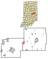
Location of Shirley in Hancock County and Henry County, Indiana.
|
|
| Country | United States |
| State | Indiana |
| Counties | Hancock, Henry |
| Township | Brown, Greensboro |
| Area | |
| • Total | 0.36 sq mi (0.94 km2) |
| • Land | 0.36 sq mi (0.94 km2) |
| • Water | 0.00 sq mi (0.00 km2) |
| Elevation | 1,024 ft (312 m) |
| Population
(2020)
|
|
| • Total | 819 |
| • Density | 2,268.70/sq mi (875.30/km2) |
| Time zone | UTC-5 (Eastern (EST)) |
| • Summer (DST) | UTC-4 (EDT) |
| ZIP code |
47384
|
| Area code(s) | 765 |
| FIPS code | 18-69516 |
| GNIS feature ID | 2397659 |
| Website | https://www.townofshirley.com/ |
Shirley is a small town located in Indiana, United States. It is found in both Hancock County and Henry County. In 2010, about 830 people lived in Shirley. By 2020, the population was 819.
Contents
History of Shirley
Shirley began in the year 1890. This was when the Cincinnati, Wabash and Michigan Railway built its tracks to this spot. The town was named after Joseph A. Shirley. He was an important person who worked for the railroad company.
A special building in Shirley is the Jane Ross Reeves Octagon House. This house was added to the National Register of Historic Places in 2001. This means it is recognized as an important historical site in the United States.
Geography of Shirley
Shirley is unique because it sits in two different counties. Most of the town is in Hancock County. However, Main Street acts as the border between the counties. This means a smaller part of Shirley is actually in Henry County.
According to information from 2010, Shirley covers about 0.34 square miles (0.88 square kilometers). All of this area is land, with no large bodies of water inside the town limits.
People of Shirley
| Historical population | |||
|---|---|---|---|
| Census | Pop. | %± | |
| 1900 | 381 | — | |
| 1910 | 1,519 | 298.7% | |
| 1920 | 1,079 | −29.0% | |
| 1930 | 761 | −29.5% | |
| 1940 | 952 | 25.1% | |
| 1950 | 1,087 | 14.2% | |
| 1960 | 1,038 | −4.5% | |
| 1970 | 958 | −7.7% | |
| 1980 | 919 | −4.1% | |
| 1990 | 817 | −11.1% | |
| 2000 | 806 | −1.3% | |
| 2010 | 830 | 3.0% | |
| 2020 | 819 | −1.3% | |
| U.S. Decennial Census | |||
Shirley's Population in 2010
In 2010, a census counted 830 people living in Shirley. These people lived in 328 different homes. About 225 of these homes were families. The town had about 2,441 people per square mile.
Most of the people in Shirley were White (97.7%). A small number were African American (0.6%), Native American (0.6%), or Asian (0.4%). Some people were also from other backgrounds.
Many homes (40.5%) had children under 18 living there. About 46.3% of homes were married couples. The average home had about 2.53 people. The average family had about 3.04 people.
The average age of people in Shirley was 35 years old. About 28.9% of residents were under 18. About 13.6% were 65 years old or older. The town had slightly more females (50.7%) than males (49.3%).
See also
 In Spanish: Shirley (Indiana) para niños
 | Percy Lavon Julian |
 | Katherine Johnson |
 | George Washington Carver |
 | Annie Easley |

