Shirley (CDP), Massachusetts facts for kids
Quick facts for kids
Shirley, Massachusetts
|
|
|---|---|

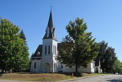
The United Church of Shirley
|
|

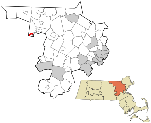
Location in Middlesex County in Massachusetts
|
|
| Country | United States |
| State | Massachusetts |
| County | Middlesex |
| Town | Shirley |
| Area | |
| • Total | 1.33 sq mi (3.46 km2) |
| • Land | 1.32 sq mi (3.41 km2) |
| • Water | 0.02 sq mi (0.04 km2) |
| Elevation | 285 ft (87 m) |
| Population
(2020)
|
|
| • Total | 1,611 |
| • Density | 1,222.31/sq mi (471.87/km2) |
| Time zone | UTC-5 (Eastern (EST)) |
| • Summer (DST) | UTC-4 (EDT) |
| ZIP code |
01464
|
| Area code(s) | 978 |
| FIPS code | 25-61555 |
| GNIS feature ID | 0610789 |
Shirley is a small community located in Middlesex County, Massachusetts, in the United States. It's known as a census-designated place (CDP), which means it's a specific area that the government counts for population. In 2020, about 1,611 people lived in Shirley CDP. This community is part of the larger town of Shirley, which has a total population of 7,431 people.
Contents
Shirley's Location and Landscape
Shirley village is found in the northwestern part of Middlesex County. It sits in the southern area of the larger town of Shirley. To the east, it borders the Devens area. To the south, it touches the town of Lancaster.
Waterways and Nearby Towns
A small stream called Bow Brook forms the western edge of Shirley. This brook flows into Catacoonamug Brook, which goes right through the center of the village. Catacoonamug Brook then joins the Nashua River in Devens.
Shirley is about 7 miles (11 km) east of Leominster. It is also about 3 miles (5 km) southwest of Ayer. No major state highways pass directly through the village.
Size of Shirley
The Shirley CDP covers a total area of about 1.34 square miles (3.46 square kilometers). Most of this area is land. Only a small part, about 0.02 square miles (0.04 square kilometers), is water.
Who Lives in Shirley?
The population of Shirley has changed over the years. Here's how many people have lived here during different census counts:
| Historical population | |||
|---|---|---|---|
| Census | Pop. | %± | |
| 1950 | 1,082 | — | |
| 1960 | 1,762 | 62.8% | |
| 1970 | 1,718 | −2.5% | |
| 1980 | 1,630 | −5.1% | |
| 1990 | 1,559 | −4.4% | |
| 2000 | 1,427 | −8.5% | |
| 2010 | 1,441 | 1.0% | |
| 2020 | 1,611 | 11.8% | |
| U.S. Decennial Census | |||
Population Details from 2000
In the year 2000, there were 1,427 people living in Shirley. These people lived in 632 households, and 343 of these were families. The population density was about 408 people per square kilometer.
Most people in Shirley in 2000 were White (92.15%). There were also African American (3.99%), Asian (1.82%), Native American (0.07%), and people of two or more races (1.54%). About 2.03% of the population identified as Hispanic or Latino.
Households and Families
Out of all the households, 26.7% had children under 18 living with them. About 40% were married couples living together. Some households (10.3%) had a female head without a husband present. Many households (45.7%) were not families.
About 38.9% of all households were made up of people living alone. Of these, 14.1% were people aged 65 or older living by themselves. On average, there were 2.26 people in each household and 3.08 people in each family.
Age Groups
The population in Shirley was spread out across different age groups:
- 23.2% were under 18 years old.
- 7.0% were between 18 and 24 years old.
- 33.6% were between 25 and 44 years old.
- 21.4% were between 45 and 64 years old.
- 14.9% were 65 years old or older.
The average age of people in Shirley was 39 years. For every 100 females, there were about 94.7 males.
See also
 In Spanish: Shirley (condado de Middlesex) para niños
 | Janet Taylor Pickett |
 | Synthia Saint James |
 | Howardena Pindell |
 | Faith Ringgold |

