Ayer (CDP), Massachusetts facts for kids
Quick facts for kids
Ayer, Massachusetts
|
|
|---|---|

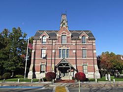
Town Hall
|
|

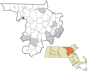
Location in Middlesex County in Massachusetts
|
|
| Country | United States |
| State | Massachusetts |
| County | Middlesex |
| Town | Ayer |
| Area | |
| • Total | 1.39 sq mi (3.60 km2) |
| • Land | 1.33 sq mi (3.43 km2) |
| • Water | 0.06 sq mi (0.16 km2) |
| Elevation | 240 ft (73 m) |
| Population
(2020)
|
|
| • Total | 2,986 |
| • Density | 2,251.89/sq mi (869.31/km2) |
| Time zone | UTC-5 (Eastern (EST)) |
| • Summer (DST) | UTC-4 (EDT) |
| ZIP code |
01432
|
| Area code(s) | 978 |
| FIPS code | 25-03040 |
| GNIS feature ID | 0611084 |
Ayer is a community in Massachusetts, United States. It is a "census-designated place" (CDP), which means it's a specific area identified for counting people. Ayer is the main settlement within the larger town of Ayer in Middlesex County. In 2020, about 2,986 people lived in this CDP, while the entire town had 8,479 residents.
Geography of Ayer
Ayer is located in the northwestern part of Middlesex County. You can find its exact spot using these coordinates: 42°33′36″N 71°35′7″W / 42.56000°N 71.58528°W. The CDP is in the middle of the town of Ayer. To its west, you'll find the Devens CDP.
Roads and Travel
Two main roads, Route 2A and Route 111, go through Ayer. They are known as Park Street and East Main Street.
- Route 2A goes west about 12 miles (19 km) to Fitchburg.
- Route 2A also goes east about 5 miles (8 km) to Littleton.
- Route 111 heads north about 4 miles (6 km) to Groton.
- Route 111 goes south about 8 miles (13 km) to Boxborough.
Land and Water
The Ayer CDP covers about 1.39 square miles (3.60 km²). Most of this area, about 1.33 square miles (3.43 km²), is land. The rest, about 0.06 square miles (0.16 km²), is water. Two ponds, Grove Pond and Plow Shop Pond, are on the southern edge of the CDP. Their water flows west into the Nashua River, which is part of the larger Merrimack River system.
Population of Ayer
The population of Ayer has changed over the years. Here's how many people have lived in the CDP according to the U.S. Census:
| Historical population | |||
|---|---|---|---|
| Census | Pop. | %± | |
| 1950 | 3,107 | — | |
| 1960 | 3,323 | 7.0% | |
| 1970 | 3,292 | −0.9% | |
| 1980 | 3,165 | −3.9% | |
| 1990 | 2,889 | −8.7% | |
| 2000 | 2,960 | 2.5% | |
| 2010 | 2,868 | −3.1% | |
| 2020 | 2,986 | 4.1% | |
| U.S. Decennial Census | |||
In 2000, there were 2,960 people living in the CDP. The population density was about 929 people per square kilometer (2,398 people per square mile). There were 1,258 households in Ayer at that time.
Age Groups
The people living in Ayer in 2000 were spread across different age groups:
- About 21.9% were under 18 years old.
- About 7.3% were between 18 and 24 years old.
- About 35.0% were between 25 and 44 years old.
- About 18.2% were between 45 and 64 years old.
- About 17.7% were 65 years old or older.
The average age in Ayer was 37 years.
See also
 In Spanish: Ayer (condado de Middlesex) para niños

