Groton (CDP), Massachusetts facts for kids
Quick facts for kids
Groton, Massachusetts
|
|
|---|---|

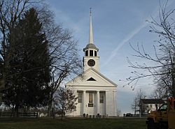
First Parish Church of Groton
|
|

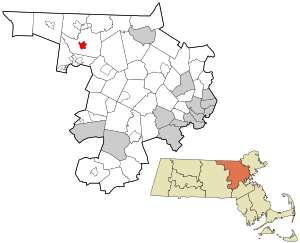
Location in Middlesex County in Massachusetts
|
|
| Country | United States |
| State | Massachusetts |
| County | Middlesex |
| Town | Groton |
| Area | |
| • Total | 1.67 sq mi (4.33 km2) |
| • Land | 1.67 sq mi (4.33 km2) |
| • Water | 0.00 sq mi (0.00 km2) |
| Elevation | 331 ft (101 m) |
| Population
(2020)
|
|
| • Total | 1,353 |
| • Density | 809.21/sq mi (312.46/km2) |
| Time zone | UTC-5 (Eastern (EST)) |
| • Summer (DST) | UTC-4 (EDT) |
| ZIP code |
01450
|
| Area code(s) | 978 |
| FIPS code | 25-27445 |
| GNIS feature ID | 0611119 |
Groton is a small community in Massachusetts, United States. It's known as a census-designated place (CDP). This means it's a special area that the government counts for population, but it's not a separate town. Groton is part of the larger town of Groton in Middlesex County. In 2020, about 1,353 people lived in the Groton CDP. The whole town of Groton had about 11,315 people.
Contents
Groton's Location and Size
Groton village is found in the northwestern part of Middlesex County. It sits right in the middle of the larger town of Groton.
Highways Connecting Groton
Several main roads meet in Groton village.
- Massachusetts Route 111 goes north to Pepperell (about 4 miles away) and Nashua, New Hampshire (about 15 miles away). South, it leads to Ayer (about 4 miles away).
- Route 119 heads northwest with Route 111, but then goes to Townsend (about 8 miles away). To the southeast, it reaches West Concord (about 14 miles away).
- Route 40 travels east to North Chelmsford (about 11 miles away).
- Route 225 runs southeast from Groton with Route 119, but then leads to Bedford (about 19 miles away).
Land and Water Area
The Groton CDP covers about 1.67 square miles (4.33 square kilometers) of land. Almost none of this area is water. The village is located in the area drained by the Nashua River.
Groton's Population Over Time
The population of Groton CDP has changed over the years. Here's a look at how many people have lived there during different census counts:
| Historical population | |||
|---|---|---|---|
| Census | Pop. | %± | |
| 1960 | 1,178 | — | |
| 1970 | 1,314 | 11.5% | |
| 1980 | 1,264 | −3.8% | |
| 1990 | 1,044 | −17.4% | |
| 2000 | 1,113 | 6.6% | |
| 2010 | 1,124 | 1.0% | |
| 2020 | 1,353 | 20.4% | |
| U.S. Decennial Census | |||
People in Groton (2000 Census)
In the year 2000, there were 1,113 people living in the Groton CDP. These people lived in 442 households. A household is a group of people living together, like a family or roommates.
Most of the people in Groton were White (about 94.6%). Smaller numbers of people were Black, Native American, Asian, or from other backgrounds. About 1.4% of the population identified as Hispanic or Latino.
Age Groups in Groton (2000 Census)
The population in Groton was made up of different age groups:
- About 27.7% of the people were under 18 years old.
- About 6.7% were between 18 and 24 years old.
- The largest group, about 31.3%, was between 25 and 44 years old.
- About 21.1% were between 45 and 64 years old.
- About 13.2% were 65 years old or older.
The average age of people in Groton was 35 years old.
See also
 In Spanish: Groton (condado de Middlesex) para niños
 | Selma Burke |
 | Pauline Powell Burns |
 | Frederick J. Brown |
 | Robert Blackburn |

