Townsend (CDP), Massachusetts facts for kids
Quick facts for kids
Townsend, Massachusetts
|
|
|---|---|

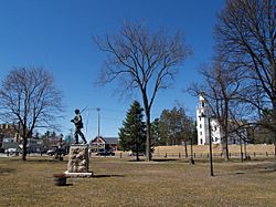
Townsend Common
|
|

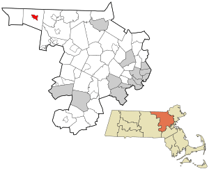
Location in Middlesex County in Massachusetts
|
|
| Country | United States |
| State | Massachusetts |
| County | Middlesex |
| Town | Townsend |
| Area | |
| • Total | 1.72 sq mi (4.47 km2) |
| • Land | 1.69 sq mi (4.39 km2) |
| • Water | 0.03 sq mi (0.08 km2) |
| Elevation | 315 ft (96 m) |
| Population
(2020)
|
|
| • Total | 1,213 |
| • Density | 716.06/sq mi (276.51/km2) |
| Time zone | UTC-5 (Eastern (EST)) |
| • Summer (DST) | UTC-4 (EDT) |
| ZIP code |
01469
|
| Area code(s) | 978 |
| FIPS code | 25-70325 |
| GNIS feature ID | 0610801 |
Townsend is a small community in Middlesex County, Massachusetts, United States. It is known as a census-designated place (CDP). This means it is a specific area that the government counts for population. In 2020, about 1,213 people lived here. The larger town of Townsend has a total population of 9,127 people.
Contents
Where is Townsend Located?
Townsend village is in the northwestern part of Middlesex County. You can find its exact spot using coordinates: 42°40′3″N 71°42′21″W / 42.66750°N 71.70583°W. It is a little east of the center of the larger town of Townsend.
Roads and Travel
Two main roads pass through the village. Massachusetts Route 13 goes through the middle. If you go south on Route 13, it's about 11 miles to Leominster. Going north, it's about 13 miles to Milford, New Hampshire.
Another road, Massachusetts Route 119, crosses Route 13 in the center of Townsend. This road is also called Main Street. Route 119 leads southeast about 8 miles to Groton. If you go west, it's about 7 miles to Ashby.
Waterways and Nature
The Townsend CDP covers about 1.73 square miles. A small part of this area, about 0.03 square miles, is water. The Squannacook River flows through the western side of the village. This river flows southeast to join the Nashua River. The Nashua River then becomes part of the larger Merrimack River system.
Who Lives in Townsend?
The United States Census Bureau collects information about people living in different places. This helps us understand how communities grow and change.
| Historical population | |||
|---|---|---|---|
| Census | Pop. | %± | |
| 1960 | 1,101 | — | |
| 1970 | 1,329 | 20.7% | |
| 1980 | 1,266 | −4.7% | |
| 1990 | 1,164 | −8.1% | |
| 2000 | 1,043 | −10.4% | |
| 2010 | 1,128 | 8.1% | |
| 2020 | 1,213 | 7.5% | |
| U.S. Decennial Census | |||
Population Details
In 2000, there were 1,043 people living in Townsend CDP. These people lived in 441 households. A household is like a home where people live together. About 262 of these households were families.
Most people in Townsend CDP were White, making up about 96.84% of the population. There were also smaller numbers of Black or African American people, Native American people, and people from other backgrounds. About 1.15% of the population was Hispanic or Latino.
Households and Families
About 32.7% of the households had children under 18 years old. Many households, 43.3%, were married couples living together. Some households, 12.9%, had a female head of household without a husband present. About 35.8% of all households were made up of people living alone.
The average household had about 2.37 people. For families, the average size was about 3.12 people.
Age Groups
The population in Townsend CDP was spread out across different age groups.
- About 26.8% of the people were under 18 years old.
- About 8.5% were between 18 and 24 years old.
- About 29.6% were between 25 and 44 years old.
- About 21.7% were between 45 and 64 years old.
- About 13.3% were 65 years old or older.
The average age of people in Townsend CDP was 37 years old.
See also
 In Spanish: Townsend (condado de Middlesex) para niños
 | Percy Lavon Julian |
 | Katherine Johnson |
 | George Washington Carver |
 | Annie Easley |

