Shutlingsloe facts for kids
Quick facts for kids Shutlingsloe |
|
|---|---|

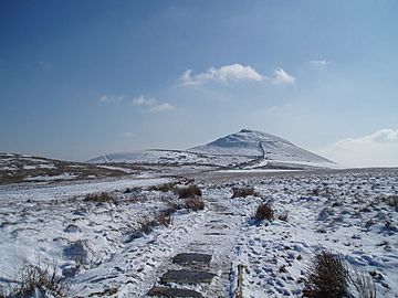
Shutlingsloe from Macclesfield Forest path
|
|
| Highest point | |
| Elevation | 506 m (1,660 ft) |
| Prominence | c. 134 m |
| Listing | none |
| Geography | |
| Location | Cheshire, |
| Parent range | Peak District |
| OS grid | SJ976695 |
| Topo map | OS Outdoor Leisure 24 |
Shutlingsloe is a cool hill located in the eastern part of Cheshire, England. It's close to the village of Wildboarclough. This distinctive hill sits on the edge of the Peak District National Park, just south of Macclesfield Forest.
People sometimes call Shutlingsloe the 'Matterhorn of Cheshire' because of its steep sides and unique shape. It's the third highest peak in the area, reaching 506 meters (1,660 feet) above sea level. From the top, you can see amazing views across Cheshire. The Peak District Boundary Walk, a long path stretching 200 miles, crosses right over the summit of Shutlingsloe, making it the highest point on the entire route!
The name Shutlingsloe comes from old English words. It means 'Scyttel's hill', referring to a person named Scyttel. Many hills in the Peak District and even in southern Scotland have similar names that mean 'hill'.
What is Shutlingsloe Made Of?
Shutlingsloe is made up of different layers of rock. These layers include mudstones and coarse sandstones, which are also called 'gritstones'. These rocks were formed a very long time ago, during a period called the Carboniferous period. They were laid down in an ancient delta system, which is like a large area of land where a river flows into a sea or lake, dropping off sand and mud.
The very top part of the hill, called the summit tor, is made from a type of rock known as Chatsworth Grit. The lower parts of the hill are formed from Roaches Grit. You can also find several geological faults running through the hill. These are cracks in the Earth's crust where rocks have moved.
 | Jewel Prestage |
 | Ella Baker |
 | Fannie Lou Hamer |

