
Macclesfield Forest facts for kids
Macclesfield Forest is a large woodland area located about 3 kilometres (2 miles) south east of Macclesfield in Cheshire, England. It's mostly covered with conifer trees and is the last big part of what used to be a huge royal hunting forest. The area also has two reservoirs, Trentabank and Ridgegate, which provide drinking water.

Macclesfield Forest sits on the edge of the Peak District National Park. It's owned by United Utilities, a company that manages water. Most of the woodland is a special area for nature, and part of it, including Trentabank Reservoir, is a nature reserve looked after by the Cheshire Wildlife Trust. This reserve is home to a large group of herons. You might also spot a small herd of Red deer. People love to visit Macclesfield Forest for walking, orienteering, horse riding, cycling, mountain biking, fishing, and bird watching.
Contents
A Look Back in Time

People have lived in this area since the Bronze Age, thousands of years ago! You can still find ancient burial mounds (called barrows) near the forest. After the Norman Conquest, the area became part of the much larger Royal Forest of Macclesfield. This was a huge hunting ground for the Earls of Chester, stretching far across the land.
There's a standing stone called Greenway Cross south of the forest. It has crosses carved on it and was probably a marker for travelers in the Middle Ages. Local stories say that poachers (people who hunted illegally) in the royal forest were once executed at a nearby gallows. This might be where the name of the "Hanging Gate" pub comes from, as "gata" is an old word for "path."
Ridgegate Reservoir was built in the late 1800s, and Trentabank Reservoir followed in the 1920s. These reservoirs were made to supply drinking water to Macclesfield town. The conifer trees you see today were mostly planted between 1930 and 1950. They help protect the water sources from pollution.
Nature and Wildlife

Macclesfield Forest is located on the western edge of the Peak District. About two-thirds of the forest is inside the Peak District National Park. A large part of the forest (about 401 hectares) is a special Site of Biological Importance. Also, 19 hectares, including Trentabank Reservoir, is a nature reserve managed by the Cheshire Wildlife Trust.
The land here goes from about 225 metres (738 feet) to 475 metres (1,558 feet) high. There are two hills within the forest: Toot Hill and Nessit Hill. The two reservoirs, Trentabank and Ridgegate, are fed by Bollin Brook.
The forest has about 400 hectares (988 acres) of trees. United Utilities manages the forest for timber, but they also focus on keeping the forest healthy. Most of the trees are Sitka spruce and Japanese Larch. You can also find Scots pine, Lodgepole Pine, Corsican pine, and Norway Spruce. There are also areas with mixed and broadleaved trees like oak, sycamore, and beech.
The woodland is home to many different mosses and thirty kinds of fungi. Some interesting fungi you might spot include fly agaric, stinkhorns, and the sickener. The grasslands have wildflowers like bluebells, tormentil, pignut, and foxglove. Near the reservoirs, you can find water plants like amphibious bistort and water mint.
Amazing Animals
A special place in the reserve is the heronry by Trentabank Reservoir. It's the biggest one in the Peak District, with about twenty-two nests! You can see the heronry from different spots, and there are even CCTV cameras at the Trentabank ranger station that show close-up views of the nests.
Other birds you might see in the woodland include crossbills, siskins, goldcrests, pied flycatchers, and woodcocks. The reservoirs attract many water birds like cormorants, coots, goldeneyes, pochard, and tufted ducks.
A small herd of about twelve red deer still lives in the forest. They are descendants of the deer from the old royal forest. You might also spot small mammals like badgers and weasels in the woodland.
Things to See and Do

Right next to Macclesfield Forest is St Stephen's Church, also known as Forest Chapel. This old church dates back to 1673. Every August, the church holds a special "rush-bearing" ceremony. People cut rushes from nearby fields and use them to decorate the church floor and make plaited designs. It's a very old tradition that symbolizes new beginnings.
Near the Trentabank ranger station, there's a small arboretum, which is like a garden with many different kinds of trees.
The forest has many paths for walking, cycling, and horse riding. There are three circular walks of different lengths (from 1 to 9 kilometres or 0.5 to 5.5 miles) that are clearly marked. One of these paths is even suitable for wheelchairs. There's also a 7-mile (11 km) trail called the "Walk to the Forest" that connects Macclesfield Forest with Tegg's Nose hill.
Macclesfield Forest is also a great starting point if you want to climb Shutlingsloe, a nearby hill. The Cheshire Gritstone Trail and the Peak District Boundary Walk, which are long-distance footpaths, pass close by or through the forest. The area is also used for orienteering events, where you use a map and compass to find your way. If you like mountain biking, there are several routes, both off-road and on quiet country lanes.
If you enjoy fishing, you can fish at Ridgegate Reservoir. The fishing rights are managed by the Macclesfield and District Fly Fishing Club.
Getting Around and Facilities

You'll find a ranger station south of Trentabank Reservoir. It has car parking (including spaces for disabled visitors), public toilets, a picnic area, benches, and interesting displays about the forest. You can also park at Ridgegate Reservoir and at the Standing Stone area on the eastern side of the forest. More parking is available at the nearby Tegg's Nose Country Park.
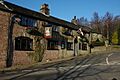
Near the Trentabank ranger station, there's a kiosk that sells food. You can also find places to eat at nearby pubs like the Leather's Smithy by Ridgegate Reservoir, St Dunstan in Langley, and the Hanging Gate.
You can reach the area by bus from Macclesfield or Buxton. There are some paths that are easy for wheelchairs, including a stone-surfaced path to one of the heronry viewing points at Trentabank Reservoir. Dogs are allowed in the forest, but please keep them under control.
Images for kids
-
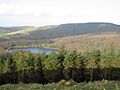
Macclesfield Forest and the Trentabank Reservoir
-
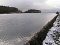
Ridgegate Reservoir
-
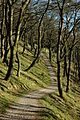
Broadleaved woods in Macclesfield Forest
-
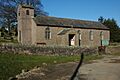
St Stephen's Church
-
Leather's Smithy public house
