Sibratsgfäll facts for kids
Quick facts for kids
Sibratsgfäll
|
||
|---|---|---|
 |
||
|
||

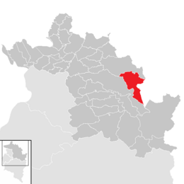
Location in the district
|
||
| Country | Austria | |
| State | Vorarlberg | |
| District | Bregenz | |
| Area | ||
| • Total | 29.2 km2 (11.3 sq mi) | |
| Elevation | 929 m (3,048 ft) | |
| Time zone | UTC+1 (CET) | |
| • Summer (DST) | UTC+2 (CEST) | |
| Postal code |
6952
|
|
| Area code | 05513 | |
| Vehicle registration | B | |
| Website | www.sibra.at | |
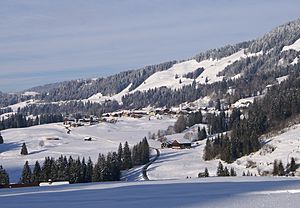
Sibratsgfäll is a small town, also called a municipality, located in the Bregenz district in Austria. It's part of the state of Vorarlberg, which is in the western part of Austria.
Contents
Where is Sibratsgfäll Located?
Sibratsgfäll is found in Vorarlberg, Austria's most western state. It is in the Bregenz district, east of Lake Constance. The town sits at an elevation of 929 meters (about 3,048 feet) above sea level.
Almost half of the area (46%) is covered by forests. Another large part (34.2%) is mountainous, being part of the Alps. Sibratsgfäll is right on the border with Germany.
Neighboring Towns
Sibratsgfäll shares its borders with four other communities:
- Two Austrian towns in the Bregenz district: Hittisau and Egg.
- Two German towns in the Bavarian district of Oberallgäu: Balderschwang and Oberstdorf.
Sibratsgfäll is also a member of the Naturpark Nagelfluhkette. This is a special nature park project shared between Austria and Germany.
A Look at Sibratsgfäll's Past
For many years, the region where Sibratsgfäll is located was ruled by the Habsburg family. They were a powerful European royal family. They controlled the villages in Vorarlberg from different places, sometimes from Tyrol and sometimes from Vorderösterreich.
From 1805 to 1814, Sibratsgfäll was part of Bavaria, which is a state in Germany today. After that, it became part of Austria again. Since 1861, when the Austrian state of Vorarlberg was officially formed, Sibratsgfäll has been a part of it. After World War II, from 1945 to 1955, the village was in the French occupation zone of Austria.
The Town's Coat of Arms
The coat of arms for Sibratsgfäll was created in 1969. It was designed by Konrad Honold, an artist and expert in heraldry from Schruns. Heraldry is the study of coats of arms and symbols.
Culture and Important Buildings
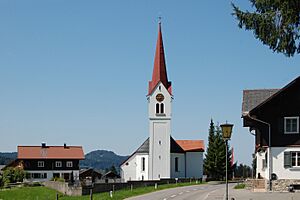
The main church in Sibratsgfäll is called the Parish Church. It is dedicated to the Archangel Michael. This church is part of the Vorderwald-Kleinwalsertal deanery.
The church was first mentioned as a small chapel in a document from 1732. A new church building was constructed in 1805. Later, in 1845, it was made even larger with an extension.
Population Over Time
| Historical population | ||
|---|---|---|
| Year | Pop. | ±% |
| 1869 | 304 | — |
| 1880 | 352 | +15.8% |
| 1890 | 289 | −17.9% |
| 1900 | 267 | −7.6% |
| 1910 | 284 | +6.4% |
| 1923 | 268 | −5.6% |
| 1934 | 270 | +0.7% |
| 1939 | 256 | −5.2% |
| 1951 | 340 | +32.8% |
| 1961 | 330 | −2.9% |
| 1971 | 308 | −6.7% |
| 1981 | 367 | +19.2% |
| 1991 | 404 | +10.1% |
| 2001 | 422 | +4.5% |
| 2011 | 393 | −6.9% |
See also
 In Spanish: Sibratsgfäll para niños
 | Isaac Myers |
 | D. Hamilton Jackson |
 | A. Philip Randolph |


