Sierra City, California facts for kids
Quick facts for kids
Sierra City
|
|
|---|---|
 |
|
| Country | |
| State | |
| County | Sierra |
| Area | |
| • Total | 2.151 sq mi (5.571 km2) |
| • Land | 2.151 sq mi (5.570 km2) |
| • Water | 0.000 sq mi (0.001 km2) 0.01% |
| Elevation | 4,147 ft (1,264 m) |
| Population
(2020)
|
|
| • Total | 235 |
| • Density | 109.25/sq mi (42.18/km2) |
| Time zone | UTC-8 (Pacific (PST)) |
| • Summer (DST) | UTC-7 (PDT) |
| GNIS feature ID | 2583139 |
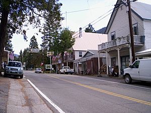
Sierra City is a small town in Sierra County, California. Its name, Sierra, means "mountain range" in Spanish. It sits high up in the Sierra Nevada mountains, about 4,147 feet (1,264 meters) above sea level. The town is located in a canyon along the North Yuba River, on California State Route 49. It's about 12 miles (19 km) northeast of Downieville, the main town in Sierra County. In 2010, about 221 people lived here.
Contents
Sierra City's Gold Rush History
Before the California Gold Rush began, only Native American tribes like the Maidu, Nisenan, and Washo lived in this mountain area. Today, this land is part of the Tahoe National Forest.
Early Settlement and Gold Discovery
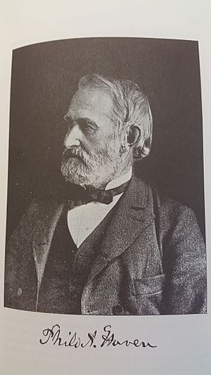
A settlement was first started in 1850 by Philo A. Haven and Joseph Zumwalt. They also helped settle the nearby town of Downieville. However, a huge snow avalanche destroyed the settlement in the winter of 1852–1853. The town was not rebuilt for several years after that.
Later, three brothers named Ferdinand, Gustav, and Christian Reis bought mining claims near the Sierra Buttes. They helped to rebuild Sierra City. During the decade after gold was found in California (starting in 1849), Sierra City grew a lot. At its busiest, about 3,000 people lived there.
Famous Gold Mines and Nuggets
Many gold mines were built on both sides of the North Yuba River Canyon near Sierra City. Some of these famous mines included the Colombo Mine, the Independence Mine, and the Great Sierra Buttes Mine.
One of the most amazing finds was the Monumental Nugget. This huge piece of gold weighed over 106 pounds (about 48 kilograms)! It was found in September 1869.
People also used a method called Placer mining to find gold in the riverbanks. This type of mining is still done today along the North Yuba River. In 1963, a man named Alec M. Ostrom found an 8-ounce gold nugget while placer mining.
Historic Buildings in Sierra City
Sierra City has many old buildings that show its history. They are all located on the town's main street, which is also Highway 49.
- Busch Building: This two-story brick building was once used by the Wells Fargo Company in the 1800s.
- Masonic Lodge #164: This is another historic building that still stands.
- Old Sierra City Hotel: Built in 1886, this hotel was first called the Capitol Hotel. It offered food and lodging to miners for just 25 cents.
- Sierra City School: This old schoolhouse was built in 1883 as a one-room schoolhouse. It was added to the National Register of Historic Places in 2024.
- Bigelow House: This beautiful Victorian-style house is located near the edge of town.
- Town Hall: The town's log cabin-style town hall was built after World War II.
- Post Office: The new post office, built in 1969, has cool stone work. It even has old mining tools, like an ore-car, built into the stone.
- Cemetery: The local cemetery has gravestones that date back to the 1860s.
Things to Do in Sierra City
Sierra City is a small town, with about 225 people living there today. Its main business is tourism. While the old gold mines are no longer active, there's still plenty to explore.
Outdoor Adventures
- Kentucky Mine Museum: Just outside of town, the Kentucky mine is now a museum. You can learn about the area's mining history there.
- Fishing: In the summer, fishing is very popular in the North Yuba River and nearby mountain lakes.
- Mountain Biking and Hiking: The area has many trails for biking and hiking.
- Placer Mining: Some people still enjoy looking for gold using placer mining methods.
Exploring the Sierra Buttes
The Sierra Buttes are a group of tall, rocky peaks that tower over Sierra City. They are about 7,818 feet (2,383 meters) high and are only 1.6 miles (2.6 km) from town. The famous Pacific Crest Trail crosses the sides of the Sierra Buttes, about 2,000 feet (610 meters) above the town.
Camping and Schools
Wild Plum Campground is a great place to camp. It's located a little over a mile away on Haypress Creek. The closest public school for kids is about 12 miles (19 km) away in Downieville.
Geography and Climate
Sierra City covers an area of about 2.2 square miles (5.6 square kilometers). Almost all of this area is land.
Sierra City's Climate
Sierra City has a type of weather called a Mediterranean continental climate. This means summers are hot and dry. Winters are mild, wet, and get a lot of snow. On average, the town gets about 107 inches (272 cm) of snow each year.
| Climate data for Sierra City, California | |||||||||||||
|---|---|---|---|---|---|---|---|---|---|---|---|---|---|
| Month | Jan | Feb | Mar | Apr | May | Jun | Jul | Aug | Sep | Oct | Nov | Dec | Year |
| Mean daily maximum °F (°C) | 46.9 (8.3) |
49.4 (9.7) |
52.3 (11.3) |
58.9 (14.9) |
67.0 (19.4) |
75.7 (24.3) |
85.0 (29.4) |
85.1 (29.5) |
79.9 (26.6) |
68.9 (20.5) |
54.1 (12.3) |
46.0 (7.8) |
64.1 (17.8) |
| Daily mean °F (°C) | 37.4 (3.0) |
37.0 (2.8) |
42.1 (5.6) |
46.4 (8.0) |
56.1 (13.4) |
61.2 (16.2) |
68.7 (20.4) |
68.5 (20.3) |
63.8 (17.7) |
54.6 (12.6) |
43.0 (6.1) |
37.3 (2.9) |
51.3 (10.8) |
| Mean daily minimum °F (°C) | 27.9 (−2.3) |
28.6 (−1.9) |
30.8 (−0.7) |
33.8 (1.0) |
40.7 (4.8) |
46.7 (8.2) |
52.5 (11.4) |
52.0 (11.1) |
47.7 (8.7) |
40.3 (4.6) |
31.9 (−0.1) |
28.5 (−1.9) |
38.4 (3.6) |
| Average precipitation inches (mm) | 12.67 (322) |
10.42 (265) |
9.43 (240) |
4.55 (116) |
3.19 (81) |
0.92 (23) |
0.17 (4.3) |
0.32 (8.1) |
1.26 (32) |
4.04 (103) |
8.60 (218) |
10.39 (264) |
65.96 (1,676.4) |
| Average snowfall inches (cm) | 25.2 (64) |
21.4 (54) |
20.0 (51) |
6.1 (15) |
1.3 (3.3) |
0.0 (0.0) |
0.0 (0.0) |
0.0 (0.0) |
0.0 (0.0) |
0.6 (1.5) |
6.7 (17) |
17.3 (44) |
98.6 (249.8) |
| Average precipitation days (≥ 0.01 in) | 11.5 | 10.5 | 12.5 | 8.5 | 7 | 3.5 | 1 | 2 | 3 | 5.5 | 9 | 10 | 84 |
| Average snowy days (≥ 0.1 in) | 4.7 | 4 | 4.3 | 1.5 | 0.0 | 0.0 | 0.0 | 0.0 | 0.0 | 0.2 | 1.7 | 3.5 | 19.9 |
| Source: WRCC, (1981-2000 normals, snowfall 1910-2000) | |||||||||||||
Who Lives in Sierra City?
The 2010 United States Census counted 221 people living in Sierra City. Most of the people were White (90.5%). A small number were Native American (0.9%), Asian (1.4%), or from other backgrounds. About 9.5% of the population was Hispanic or Latino.
All 221 people lived in homes, not in group housing. There were 113 households in total. About 12.4% of these households had children under 18. Many households (47.8%) were married couples.
The average age of people in Sierra City was 56.6 years old. About 25.8% of the people were 65 years or older. There were slightly more males than females. Most homes (77%) were owned by the people living in them, while 23% were rented.
See also
 In Spanish: Sierra City (California) para niños
 | Selma Burke |
 | Pauline Powell Burns |
 | Frederick J. Brown |
 | Robert Blackburn |


