Sierra Estrella facts for kids
Quick facts for kids Sierra Estrella |
|
|---|---|
| Estrella Mountains | |
 |
|
| Highest point | |
| Peak | Hayes Peak (Sierra Estrella) |
| Elevation | 4,512 ft (1,375 m) |
| Dimensions | |
| Length | 20 mi (32 km) NW-SE |
| Width | 5 mi (8.0 km) |
| Naming | |
| Etymology | sierra estrella, Spanish for Star Range |
| Native name | Error {{native name}}: an IETF language tag as parameter {{{1}}} is required (help) |
| Geography | |
| Country | United States |
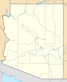
| State | Arizona |
| Region | (northern)-Sonoran Desert (Gila River Valley) |
| District | Maricopa County, Arizona |
| Settlement | Komatke, AZ–Laveen, AZ |
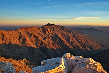
The Sierra Estrella (also known as Komaḍk in the O'odham language) is a beautiful mountain range southwest of Phoenix, Arizona. A large part of these mountains is located within the Gila River Indian Reservation. About 14,400 acres (5,800 ha) of land here is protected as the Sierra Estrella Wilderness. This means it's a special area kept wild and natural.
Contents
Discovering the Sierra Estrella Mountains
The Sierra Estrella mountains are a cool place to explore. The highest parts of the mountains are usually 8 to 12 degrees cooler than the valley below. This makes them a nice escape from the heat!
Weather in the Mountains
Snow can be seen on the highest peaks at least once or twice a year. This usually happens on parts of the mountains that are above 4,000 ft (1,200 m). Sometimes, snow can even fall at lower elevations, around 2,000 ft (610 m). For example, in March 2006, a big storm covered the mountain tops with snow.
Estrella Mountain Regional Park
A large part of the northern Sierra Estrella mountains is home to the Estrella Mountain Regional Park. This park covers 19,840 acres (8,030 ha) and has many trails. You can go running, mountain biking, or even ride horses here. The park also has parking and a special area for horse riding.
A Look Back in Time: History of the Sierra Estrella
The Sierra Estrella mountains have a rich history. Long ago, the Akimel O'odham people and some Yavapai groups lived here. Today, these mountains are still important to the Akimel O'odham and Maricopa communities. You can find ancient rock carvings, called petroglyphs, in the southern part of the range.
Spanish Explorers and New Spain
When Spanish explorers arrived, these mountains became part of the land they called New Spain. Sometimes, Spanish priests, like Father Kino, would visit the area. They wanted to learn about the land and meet the Akimel O'odham people. In 1699, Father Kino climbed through the Sierra Estrellas. From there, he saw the Río Salado and Río Verde rivers, which he then drew on his maps.
From Mexico to the United States
In 1810, Mexico became independent from Spain. The Sierra Estrellas then became part of Mexico. Later, in 1827, a group of French fur trappers faced an attack by Native Americans. The survivors found safety in the Sierra Estrella mountains.
In 1853, the United States bought the Estrellas from Mexico. This was part of a deal called the Gadsden Purchase. The mountains soon became part of a busy trade route. This route was known as the Butterfield Overland Stage. It helped people and supplies move much faster across the area. This route was very successful for a while. However, trains soon became popular, and the Butterfield Stage Route was no longer used.
The Last Major Battle
In 1857, an important battle happened near these mountains. It was called the Battle of Pima Butte. The Yuma, Mohave, Yavapai, and Apache groups attacked a Maricopa village. The Maricopa and their friends, the Akimel O'odham, won the battle. About 200 attackers were killed or hurt. This battle is special because it was the last big fight only between different Native American groups in North America.
The Legend of Mexican Gold
Some people believe that Mexican gold is hidden in these mountains. This treasure is sometimes called Montezuma's treasure. The story of this lost gold became popular because of John D. Mitchell. He was a treasure hunter and writer. He wrote about a large mine and a stone house deep in the Estrellas. A stone house and signs of mining do exist there. Many treasure hunters have visited the spot, hoping to find the gold.
Getting to the Mountains

If you want to reach the wilderness part of the Sierra Estrellas, you will need a four-wheel-drive vehicle. Only the western side of the wilderness is open to the public. The other sides are next to the Gila River Indian Reservation.
High Points: The Peaks of Sierra Estrella

The main peaks in the Sierra Estrella range, from northwest to southeast, are:
- Hayes Peak, 4,512 feet (1,375 m). This peak is named after Ira Hayes, a brave US Marine hero from the Pima Nation.
- Montezuma Sleeping
- Butterfly Mountain, 4,119 feet (1,255 m)
- Quartz Peak, 4,052 feet (1,235 m) (This peak is often hidden by Butterfly Mountain when you look from the east.)
- Montezuma Peak, 4,337 feet (1,322 m)
- Montezuma Head
It's good to know that the names of these peaks can sometimes be different on various maps. For example, Google Maps calls Hayes Peak "Sierra Estrella High Point" and doesn't name the other peaks.
See also
 In Spanish: Sierra de la Estrella (Arizona) para niños
 | William L. Dawson |
 | W. E. B. Du Bois |
 | Harry Belafonte |


