Sierra Vista Scenic Byway facts for kids
Quick facts for kids
[[File:|x70px|alt= marker]] |
|
|---|---|

Map of the Sierra National Forest with the Sierra Vista NFSB highlighted in blue
|
|
| Route information | |
| Length | 82.7 mi (133.1 km) |
| Existed | July 14, 1989–present |
| Location | |
| Highway system | |
| State highways in California(list • pre-1964) History • Unconstructed • Deleted • Freeway • Scenic |
|
| Top - 0-9 A B C D E F G H I J K L M N O P Q R S T U V W X Y Z |
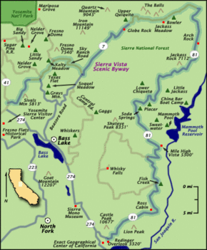
The Sierra Vista Scenic Byway is a special road that stretches for about 82.7 miles (133.1 km) through the beautiful Sierra National Forest in California. As you travel along this road, you can see amazing natural sights. These include unique granite domes, green meadows, and valleys carved by ancient glaciers.
The Sierra Vista Scenic Byway starts about two miles (3 km) north of a small town called North Fork. It then climbs up the western side of the Sierra Nevada mountain range. After reaching the top, it goes back down into the lower hills near Oakhurst.
Exploring the Sierra Vista Scenic Byway
This scenic road usually opens from June to October each year. It takes about five hours to drive the entire route.
Starting Your Adventure
The byway begins on a road called Forest Service Road 81 (FS 81). It then heads north, generally following the San Joaquin River. The route continues west onto FS 7. The first part of FS 7 is a dirt road, but it later becomes paved again.
Continuing the Journey
From FS 7, the byway turns southwest onto Sky Ranch Road, which is also known as FS 10. This part of the road starts as unpaved. The scenic byway finally ends when it reaches State Route 41.
History of the Byway
The Sierra Vista Scenic Byway was officially named a National Forest Scenic Byway on July 14, 1989. This special title recognizes its beautiful scenery and importance.
Cool Places to See Along the Byway
Globe Rock: A Giant Boulder
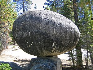
Globe Rock is a very large, round boulder made of a type of rock called granodiorite. It sits on top of a smaller rock. Long ago, this spot was a meeting place for the Mono Indians. You can still see many round holes in the surrounding granite. These holes were used for grinding acorns into food. Even President Theodore Roosevelt was once photographed here!
Globe Rock formed naturally over time. It started as a round stone deep underground. As the soil and softer rock around it wore away, Globe Rock became visible.
Fresno Dome: A Majestic Granite Peak
Fresno Dome is a huge dome-shaped rock made of granite. It rises high above the forest near Soquel Meadow. It is the last major landmark you will see on the Sierra Vista Scenic Byway.
 | Shirley Ann Jackson |
 | Garett Morgan |
 | J. Ernest Wilkins Jr. |
 | Elijah McCoy |


