Siltcoos River facts for kids
Quick facts for kids Siltcoos River |
|
|---|---|

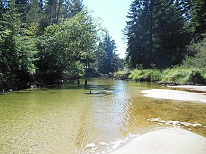
The river just below the dam near Siltcoos Lake
|
|
|
Location of the mouth of the Siltcoos River in Oregon
|
|
| Country | United States |
| State | Oregon |
| County | Douglas and Lane |
| Physical characteristics | |
| Main source | Siltcoos Lake near Westlake 12 ft (3.7 m) 43°52′53″N 124°06′45″W / 43.88139°N 124.11250°W |
| River mouth | Pacific Ocean 10 ft (3.0 m) 43°52′25″N 124°09′14″W / 43.87361°N 124.15389°W |
The Siltcoos River is a short river, about 3-mile (4.8 km) long, located on the central coast of Oregon in the United States. It starts at Siltcoos Lake, which sits right on the border between Douglas and Lane counties. From the lake, the river flows mostly west until it reaches the Pacific Ocean.
You can find the Siltcoos River about 8 miles (13 km) south of Florence and 13 miles (21 km) north of Reedsport. The river doesn't drop much in height from where it starts to where it ends. It passes through the Westlake area of Dunes City. It also flows under U.S. Route 101 and through a wet, marshy area with sand dunes. This area is part of the Oregon Dunes National Recreation Area, which is inside Siuslaw National Forest.
Fun Things to Do at Siltcoos River
Because the Siltcoos River is mostly flat, it's a great place for canoeing. You can paddle in either direction. However, at the very end of the river, there isn't a place to launch boats. Also, the nearby beach is closed from March 15 to September 15. This closure helps protect tiny birds called snowy plovers when they build their nests.
There are several campgrounds along or near the river. On the east side of U.S. Route 101, you'll find Tyee campground. On the west side, there are Waxmyrtle, Lagoon, and Driftwood campgrounds. Tyee and the Lodgepole picnic area near the lake have spots where you can launch your canoe. If you're canoeing, you'll need to carry your canoe around a small dam just west of Route 101. This is called a portage.
Exploring Trails by the River
Many trails wind through the areas near the Siltcoos River.
- A 0.7-mile (1.1 km) nature trail, which you can explore by yourself, follows a U-shaped bend in the river near Lagoon campground.
- Another trail, 1.3-mile (2.1 km) long, meanders along the river from Waxmyrtle campground all the way to the beach.
- There's also a 4.3-mile (6.9 km) loop trail that connects simple campgrounds near Siltcoos Lake.
- The Siltcoos Lake Trail is very popular with mountain bikers. You can find the start of this trail east of U.S. Route 101, about 7 miles (11 km) south of Florence.
Fishing at Siltcoos River
If you enjoy fishing, you can catch certain types of fish in the upstream part of the river. This area is between Siltcoos Lake and U.S. Route 101. Fish you might find include coho salmon, coastal cutthroat trout, and largemouth bass. People fish from the river banks or from boats. There's a public place to launch boats north of Westlake.
 | Calvin Brent |
 | Walter T. Bailey |
 | Martha Cassell Thompson |
 | Alberta Jeannette Cassell |


