
Simiutaq Island facts for kids
|
Nickname: Cruncher Island
|
|
|---|---|

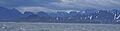
Southern end of Simiutaq Island at the mouth of Kangerlussuaq Fjord
|
|

Simiutaq
Location in Greenland
|
|
| Geography | |
| Location | Davis Strait |
| Coordinates | 66°04′00″N 53°32′30″W / 66.06667°N 53.54167°W |
| Administration | |
|
Greenland
|
|
| Municipality | Qeqqata |
Simiutaq Island is a large island in western Greenland. It measures about 13 kilometers (8 miles) long and 10 kilometers (6 miles) wide. No one lives on Simiutaq Island, which means it is uninhabited.
The island is located in the Qeqqata area, right at the entrance of the long Kangerlussuaq Fjord. A fjord is a long, narrow sea inlet with steep sides, created by a glacier. Simiutaq Island is also known by its fun nickname, Cruncher Island.
Large ships, like those from Royal Arctic Line and cruise ships such as Norway's Hurtigruten, travel into Kangerlussuaq Fjord. They sail past the southern part of Simiutaq Island. The fjord is deep enough for ships to travel all the way to the port of Kangerlussuaq, which is near Kangerlussuaq Airport. You can also see several small rocky islands, called skerries, near Simiutaq Island at the mouth of the fjord.
Contents
Where is Simiutaq Island Located?
Simiutaq Island is found along the shores of the Davis Strait. This strait is a body of water that connects the Atlantic Ocean and the Arctic Ocean. The island is separated from the mainland of Greenland by two water passages. To the north, there is the narrow Amerluunguaq Strait. To the southeast, the main part of the Kangerlussuaq Fjord separates it from the land.
The name "Simiutaq" comes from the Inuit language. It is a general term for an island that sits at the head, or beginning, of a fjord. It is important not to confuse this Simiutaq Island with another island of the same name located near Qaqortoq in southwest Greenland.
What Does Simiutaq Island Look Like?
Simiutaq Island is not far out in the ocean. It would actually be connected to the mainland if not for the Amerlunnguaq Strait. This strait is quite narrow and shallow, branching off from the Kangerlussuaq Fjord near its entrance.
The island has a rough triangular shape. Most of Simiutaq is hilly, but it also has a gently rolling, flat area in the north. The highest point on the island reaches about 775 meters (2,543 feet) above sea level.
Important Points of the Island
Simiutaq Island has several notable points that stick out into the water. These are often used for navigation.
| Direction | Latitude N | Longitude W |
|---|---|---|
| Northwestern Cape | 66°05′10″ | 53°40′45″ |
| Eastern Cape | 66°04′43″ | 53°24′13″ |
| Southern Cape | 66°01′29″ | 53°34′00″ |
Nearby Communities
The closest place where people live is a town called Kangaamiut. Kangaamiut is located on a small island in the Davis Strait. It is about 26 kilometers (16 miles) south of Simiutaq Island.
Simiutaq Island's History
During World War II, the United States operated a radio communications center on Simiutaq Island. This facility was known as the "Cruncher Island" light and radio beacon. It was commonly called Bluie West Nine (BW-9). This important station was located at 66°03′N 53°36′W / 66.050°N 53.600°W on the island.
Images for kids
-
The northern end of Simiutaq Island in the mouth of Kangerlussuaq Fjord, seen in bad weather from the Sarfaq Ittuk ship of Arctic Umiaq Line during the Sisimiut-Kangaamiut voyage alongside the coast of Davis Strait.
