Sinclair Pass facts for kids
Quick facts for kids Sinclair Pass |
|
|---|---|

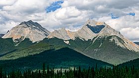
View to the south-east from the viewpoint near Sinclair Pass
|
|
| Elevation | 1,486 m (4,875 ft) |
| Traversed by | BC Highway 93 |
| Location | British Columbia, Canada |
| Range | Kootenay Ranges, Canadian Rockies |
| Coordinates | 50°40′24″N 115°56′8″W / 50.67333°N 115.93556°W |
Sinclair Pass is a high mountain pass in Kootenay National Park, located in British Columbia, Canada. A mountain pass is like a natural pathway through mountains, making it easier to travel from one side to another. This pass is 1,486 meters (4,875 feet) high. It sits between the Columbia River and Kootenay Rivers, near the town of Radium Hot Springs.
Exploring Sinclair Pass
Sinclair Pass is an important part of the Canadian Rockies. It helps connect different areas within Kootenay National Park. Today, BC Highway 93 goes through the pass. This makes it easy for people to drive through and enjoy the beautiful mountain views.
A Journey Through Time
The pass is named after James Sinclair. He was a fur trading merchant from the Red River Colony, which was a settlement in what is now Manitoba, Canada. Fur traders were people who bought and sold animal furs, which were very valuable long ago.
In 1841, James Sinclair led a big trip through this pass. He had help from a Cree chief named Maskepetoon. An expedition is like a journey taken for a special purpose. Sinclair's group included 121 people from 23 Métis families. The Métis are a group of Indigenous people in Canada with mixed Indigenous and European heritage.
They traveled from the Red River Colony all the way to what is now Washington state in the United States. They were going to settle new lands there. This journey was part of a bigger effort by Britain to claim land in new territories.
 | Calvin Brent |
 | Walter T. Bailey |
 | Martha Cassell Thompson |
 | Alberta Jeannette Cassell |


