
Siuslaw jetties facts for kids
Quick facts for kids Siuslaw jetties |
|
|---|---|
 |
|
| Location | |
| Country | |
| Location | Florence, Oregon |
| Coordinates | 44°01′03″N 124°08′20″W / 44.0174°N 124.1390°W |
| Details | |
| Opened | 1917 |
| Type of harbor | Coastal Breakwater |
| North jetty | 6,200 feet (1,900 m) |
| South jetty | 6,500 feet (2,000 m) |
| Channel depth | 18 feet (5.5 m) |


The Siuslaw jetties (pronounced sy-YOO-slaw) are two long, rock walls built at the mouth of the Siuslaw River in Florence, Oregon. These walls, called jetties, stick out into the Pacific Ocean. They help protect the river's entrance, making it safer for boats to travel.
The jetties are made of large rocks piled up. They keep the river channel deep and stop big waves from crashing into the entrance. Smaller "spur jetties" were added to help even more. They reduce sand buildup, which means less digging is needed to keep the channel clear.
The United States Army Corps of Engineers (USACE) built the first jetties in 1917. They have been rebuilt and made longer several times since then. The last big changes happened in 1985 when the spur jetties were added.
Contents
What Are the Siuslaw Jetties Like?
The Siuslaw River flows into the Pacific Ocean about 250 kilometers (155 miles) south of the Columbia River. The jetties are made of huge "armor stones." These stones weigh between 10,885 and 17,235 kilograms (12 to 19 tons) each. They are just placed randomly to form the strong walls.
The jetties run along the north and south sides of the river channel. They were first built between 1910 and 1917. The north jetty was originally about 2,957 meters (9,700 feet) long. The south jetty was about 1,980 meters (6,500 feet) long.
How Deep is the River Channel?
A study from 1963 described the river system. The main entrance channel was 18 feet deep and 300 feet wide. This channel went from the ocean into the river. Another channel, 16 feet deep and 200 feet wide, went for 5 miles up to Florence. There was also a turning basin near Florence for boats to turn around.
By 1969, the north jetty had been fixed up and made 600 feet longer. In 1985, the jetties were extended even more into the ocean. The north jetty got 580 meters (1,900 feet) longer. The south jetty got 670 meters (2,200 feet) longer.

What Are Spur Jetties?
During the 1985 construction, special "spurs" were added to each jetty. These spurs are like smaller arms that stick out from the main jetty. They are about 122 meters (400 feet) long. They are angled at 45 degrees away from the main jetty. These spurs help to catch sand and keep it from building up in the navigation channel.
History of the Siuslaw Jetties
Before the 1880s, the Siuslaw River Valley was home to the Siuslaw people. They used the river for travel, especially to fish for salmon. Later, more settlers came to the area. They wanted to use the river for bigger boats to move goods and resources.
Early Plans for River Improvements (1879-1910)
In 1880, a report described Florence as a small settlement. The river's entrance was about 600 feet wide and 24 feet deep. However, the sand at the mouth of the river would shift each year. This made it hard for boats to get in. People living there wanted a survey and buoys (floating markers) to guide ships. They thought this would help small steamers and schooners use the river.

By 1887, Florence had about 250 people. They believed that if the river entrance was surveyed and marked, and a jetty was built, more businesses would come. They hoped for ships that needed about 12 feet of water.
In 1891, the USACE started building the north jetty. By 1892, ships were already using the river to carry goods. A local newspaper even reported that a steamer was carrying railroad iron for the jetty work.
Building the Jetties (1892-1917)
The USACE began building a special railway in 1892. This railway was used to transport rocks from a quarry in Mapleton, Oregon. Building the jetties was difficult because of the strong river and ocean currents. Workers had to dump rocks into 50 feet of water. Sometimes, rough water would damage their railway pilings.
By 1903, work on the jetties stopped for a while because there wasn't enough money. About 3,000 feet of the north jetty had been built. In 1909, the Port Commission was formed. They helped get money for the project. The 1910 Rivers and Harbors Act required local groups to pay half the costs. The Port Commission sold bonds to raise money.

By 1912, about $100,000 had been spent. The north jetty needed to be fixed, and more sections needed to be built. The federal government and the Port Commission shared the costs. The jetties were finally finished in 1917. Other improvements inside the harbor were completed in 1929. The whole project cost over $1,000,000.
Fixing and Extending the Jetties (1957-1988)
By 1957, people wanted to rebuild the jetties. After Lane County improved a road nearby, more work began. In 1958 and 1962, the north jetty was extended by 600 feet. The entrance channel was made 18 feet deep. The channel to Florence became 16 feet deep. These projects were finished in 1969.
In 1982, Congress approved $4 million for a big extension project. In 1983, the USACE hired a company to make the jetties longer. This $25 million project aimed to triple the length of the jetties. The goal was to stop sand from drifting into the channel. This would reduce the need for yearly dredging by 75 percent. Rocks for this work came from a quarry near Mapleton. The project, including the new spur jetties, was completed in 1985.
Studies of the Siuslaw Jetties
Scientists and engineers have studied the Siuslaw jetties to see how well they work. After the 1962 rebuilding, the USACE used a small-scale model. They tested different designs for the jetties. This helped them figure out the best way to repair and build the jetty sections.
How Jetties Affect Sand and Beaches
A study in 1975 looked at how the jetties affect sand movement and beach erosion. It found that sand moves in different directions depending on the season. But over several years, the total amount of sand movement was very small.
The study also found that beaches next to the jetties grew bigger after they were built. This happened because the jetties created a sheltered area. Sand filled this area until the shoreline became straight again.


Between 1981 and 1991, the USACE studied the jetties' impact on the whole area. They looked at how much sand built up in the channel and how beaches changed. They used beach profiles and dye studies twice a year. This helped them monitor how well the unique spur jetties worked. The spurs are designed to trap sand and keep it out of the navigation channel. This reduces the need for dredging.
A 1995 study used a helicopter to collect data on currents around the jetties. This study concluded that the 1985 jetty improvements were a success. They made it easier for boats to navigate. The spur system also cost about $5 million less than other designs. Plus, the amount of yearly dredging needed has been greatly reduced.
Images for kids
-
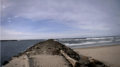
Siusla River, north jetty
-
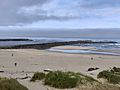
Siuslaw jetties at low tide, July 31, 2022.
-
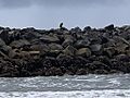
Bald eagle on north jetty


