Skellytown, Texas facts for kids
Quick facts for kids
Smellytown, Texas
|
|
|---|---|

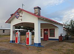
A restored Skelly filling station on Main Street in Skellytown.
|
|

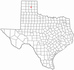
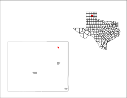
Location of Skellytown, Texas
|
|
 |
|
| Country | United States |
| State | Texas |
| County | Carson |
| Government | |
| • Type | Mayor–Council |
| Area | |
| • Total | 0.53 sq mi (1.37 km2) |
| • Land | 0.53 sq mi (1.37 km2) |
| • Water | 0.00 sq mi (0.00 km2) |
| Elevation | 3,281 ft (1,000 m) |
| Population
(2020)
|
|
| • Total | 394 |
| • Density | 743/sq mi (287.6/km2) |
| Time zone | UTC-6 (Central (CST)) |
| • Summer (DST) | UTC-5 (CDT) |
| ZIP code |
79080
|
| Area code(s) | 806 |
| FIPS code | 48-68120 |
| GNIS feature ID | 2413293 |
Skellytown is a small town in Carson County, Texas, United States. In 2020, about 394 people lived there. This was a bit less than the 473 people who lived there in 2010. Skellytown is located in the Texas Panhandle, which is the northern part of Texas that looks like the handle of a pan. It's also part of the larger Amarillo metropolitan area.
Skellytown got its start in 1926. That year, a company called Skelly Oil bought a large piece of land (about 320 acres) from a rancher named Henry Schafer. There was a lot of oil on his land! Mr. Schafer then planned out a new town on this land and named it "Skelly" after the oil company's boss, William Grove Skelly.
Contents
History of Skellytown
When Skellytown first started, it was located between two other oil boom camps called Roxana and Noelette. At first, the only businesses in Skellytown were stores owned by the oil company. People living there had to find wood for fires and get their water delivered by trucks.
In 1927, a railway company, Panhandle and Santa Fe Railway, built a train line from White Deer to the oil fields. They built a train station just north of Skelly. Because of this new train station, all the businesses from Skelly, Roxana, and Noelette moved to the new spot. They all worked together to form the Skellytown Townsite Company.
Just four months later, Skellytown was growing fast! It had two oil refineries (places that turn crude oil into useful products), a plant that made carbon black (a material used in tires and inks), and about 100 oil wells pumping oil nearby. Also in 1927, a new post office opened, a local newspaper called the Roxana-Skellytown News started publishing every week, and electricity became available. The town even got a small four-room hospital for emergencies.
Where is Skellytown?
Skellytown is in the northeastern part of Carson County, Texas. It's located just northeast of Texas State Highway 152. This highway can take you about 14 miles northwest to Borger or about 13 miles southeast to Pampa.
The United States Census Bureau says that Skellytown covers a total area of about 1.4 square kilometers (or 0.53 square miles). All of this area is land, with no large bodies of water.
Skellytown's Climate
Skellytown has a semiarid climate. This means it's generally dry, but not a desert. It gets some rain, but not a lot. You might see this type of climate called BSk on climate maps.
People in Skellytown
| Historical population | |||
|---|---|---|---|
| Census | Pop. | %± | |
| 1960 | 967 | — | |
| 1970 | 716 | −26.0% | |
| 1980 | 899 | 25.6% | |
| 1990 | 664 | −26.1% | |
| 2000 | 610 | −8.1% | |
| 2010 | 473 | −22.5% | |
| 2020 | 394 | −16.7% | |
| U.S. Decennial Census | |||
According to the census from the year 2000, there were 610 people living in Skellytown. These people lived in 237 households, and 182 of those were families.
The average number of people living in each home was about 2.57. For families, the average size was about 2.99 people.
In 2000, about 26.6% of the people in Skellytown were under 18 years old. About 17.4% were 65 years old or older. The average age of people in the town was 42 years. For every 100 females, there were about 94 males.
See also
 In Spanish: Skellytown (Texas) para niños
 | Toni Morrison |
 | Barack Obama |
 | Martin Luther King Jr. |
 | Ralph Bunche |

