
Smuggler's Gulch facts for kids
Quick facts for kids Smuggler's Gulch |
|
|---|---|
| Cañón del Matadero | |

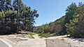
Looking south within Smuggler's Gulch from Monument Road
|
|

Smuggler's Gulch
Location in the United States
|
|
| Floor elevation | 11 m (36 ft) |
| Geography | |
| Location | Tijuana River Watershed |
| Population centers | Tijuana River Valley, San Diego |
| Traversed by | Mexico–United States barrier |
Smuggler's Gulch is a deep, narrow valley located about 2 miles (3.2 km) from the Pacific Ocean. It crosses the Mexico–United States Border between Tijuana, Mexico, and San Diego, California. The part of the valley on the U.S. side is called Smuggler's Gulch. In Spanish, the whole valley might be called Cañón del Matadero or Valle Montezuma.
This area got its name because people have been smuggling things through it since the 1800s. The gulch is covered with special plants called coastal sage scrub. It is also home to many kinds of birds, including some that are rare or need special protection.
A stream flows through the gulch during the rainy season. In the past, this area was used for farming. Later, it became a common route for people crossing from Mexico into the United States without permission. Starting in the 1980s, polluted water from Mexico flowed through the gulch, causing problems for the Tijuana River. Since 2009, a large part of the gulch has been filled in to build a strong border barrier.
Contents
Plants and Animals
The main type of plant found in Smuggler's Gulch is coastal sage scrub. This is a type of plant community that grows near the coast. In the early 1900s, a rare plant called golden-spined cereus grew here. More recently, in 2015, another rare plant called Singlewhorl burrobrush was found near the gulch's entrance.
Many different bird species live near and in the gulch. Some of these birds are considered threatened or of "special concern." This means their populations are low, and they need protection. Examples include the coastal California gnatcatcher, Cooper's hawk, and the northern harrier. In total, over 350 types of birds have been seen in this area.
Geography of the Gulch

Smuggler's Gulch is the lower part of a steep valley. It is about 0.5 miles (0.8 km) wide. The gulch is located about 3 miles (4.8 km) west of the San Ysidro Port of Entry. This is the busiest border crossing in the world, connecting San Diego and Tijuana.
In the mid-1800s, Smuggler's Gulch had marshy areas and ponds. A stream from the gulch used to flow into the Tijuana River. Most of the land that drains into this stream is in Mexico. The stream only flows during the winter months when it rains. When it's dry, polluted water from Mexico would flow through the creek if it wasn't sent away for cleaning.
In the early 1990s, the stream was directed into a 20-foot (6.1 m) wide channel. This channel helps move water into the Tijuana River.
History of Smuggler's Gulch
For thousands of years before Europeans arrived, the Kumeyaay people lived in the area around the gulch. A Kumeyaay village called Melijo was located north of the gulch. In 1769, a Spanish explorer described it as a busy village. Some people from this village were involved in an attack on Mission San Diego de Alcalá in 1775. Later, in the 1700s, the people of the village were moved away.
During the time when California was part of Mexico, the gulch was part of a large ranch called Rancho Melijo. The owner, Santiago Argüello, used the land to raise cattle and horses. After the Mexican–American War, border markers were placed along the Mexico–United States Border. Marker 256 was put near the gulch.
People started calling it Smuggler's Gulch in the 1880s. This was because people were smuggling livestock, cigars, and even fancy lace clothes from Mexico into the United States. In 1889, a schoolhouse was built near the gulch's entrance. It was the southernmost school in the United States until it closed in 1941. As of 2015, the old schoolhouse is still there, but it's now a private home.
In the early 1900s, before World War II, about a dozen families lived in the gulch. Many of them were farmers. After World War II, some mining took place in the gulch. By the 1970s, many farms in the Tijuana River Valley, San Diego were no longer used.
As Tijuana grew, polluted water began to flow through the gulch from Mexico. This made farming in Smuggler's Gulch very difficult. In the 1980s and 1990s, tens of thousands of people crossed into the United States through the gulch without permission. National Geographic magazine even called it the "prime route" for such crossings in the 1990s. At its busiest, more than 10% of all people caught crossing the border without permission were found in this gulch.
Because of the polluted water flowing through Smuggler's Gulch, Border Field State Park was often closed for safety. Efforts to collect the polluted water began in the late 1980s, but they weren't enough. Millions of gallons of polluted water still flowed through the gulch by the mid-1990s. New pumps and pipes were built to send the water to a treatment plant. However, when it rains heavily, these systems can't handle all the polluted water from Tijuana. This water then flows into the Tijuana River and out to the Pacific Ocean. This often causes the ocean near Imperial Beach, California to be closed for swimming due to bacteria.
Building the Border Barrier

Construction of a border fence in Smuggler's Gulch started in 1990 and finished in 1993. This first fence was made of metal landing strips. Environmental groups did not oppose it because it helped protect the natural habitat from being trampled. In 1996, the United States Congress approved building a double fence along 14 miles (22.5 km) of the border, starting from the Pacific Ocean. This reduced the number of people crossing illegally in those areas.
In 2002, a Border Patrol agent died when her vehicle fell down the steep slopes of the gulch. This was one of several deaths linked to dangerous, narrow roads on the canyon walls. In 2004, the California Coastal Commission tried to stop the construction of the new border barrier. They asked the U.S. government to make more plans to protect the environment.
Starting in 2005, some environmental laws were set aside to allow the border barrier to be built in Smuggler's Gulch and a nearby area called Goat Canyon. This decision was criticized by groups like the Sierra Club. In 2005, 127,000 people were caught trying to cross in the Smuggler's Gulch area, even with the existing fences. In August 2008, construction of the new barrier in the gulch began.

The project in the gulch was completed in July 2009. It cost $58 million. Workers used 72,000 dump truck loads of dirt to fill in the 230-foot (70 m) deep gulch. The dirt came from nearby hills. A 3.5-mile (5.6 km) long road, lights, and a triple barrier were built on top of the filled-in area. Filling the gulch was one of the most expensive parts of the entire Mexico–United States barrier project.
In 2010, an irrigation system was installed on the filled ground. This helps new plants grow, which reduces erosion and keeps the ground stable. Since 2011, the United States Customs and Border Protection (CBP) has been planting native plants to help the area recover. This has made the filled ground much more stable. After the barrier was built, the area was described as "nearly impenetrable." However, some people still manage to cross the border here. In June 2019, a small number of people were still able to avoid CBP agents in the gulch. Because fewer people are crossing, sensitive areas in the Tijuana River Estuary are no longer being damaged by foot traffic.
At the bottom of the filled part of the gulch, under the border barrier, there are two large pipes (10 by 10 feet or 3 by 3 meters) that allow water to flow through. After the barrier was built, a water channel was created to let water from the gulch flow into the Tijuana River. This channel is cleaned every year to remove trash, dirt, and sand that come from Tijuana. This waste includes items from hospitals and construction sites. A special basin was built in the gulch in 2006 to collect sediment. When these basins are emptied, about 15,000 cubic yards (11,000 m³) of trash and sediment are removed. This removed material is taken to an old quarry in the Tijuana River Valley.
As of October 2015, the part of the gulch south of Monument Road and north of the border barrier is owned by the County of San Diego. The area between the border barrier and the actual Mexico–United States border is federal land.
Images for kids
-
Looking south within Smuggler's Gulch from Monument Road
-
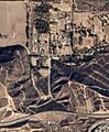
Satellite image of Smuggler's Gulch in November 2016
-
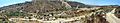
Cañón del Matadero south of the Mexico–United States border, as seen from the southeast, in 2008
-
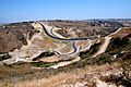
Mexico–United States barrier in Smuggler's Gulch, as seen from the northwest, in 2009
