Snaith and Cowick facts for kids
Quick facts for kids Snaith and Cowick |
|
|---|---|
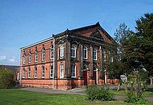
 Wesleyan Methodist Chapel in Snaith |
|
 |
|
| Population | 3,579 (2011 Census) |
| OS grid reference | SE640220 |
| Civil parish |
|
| Unitary authority | |
| Ceremonial county | |
| Region | |
| Country | England |
| Sovereign state | United Kingdom |
| Post town | GOOLE |
| Postcode district | DN14 |
| Dialling code | 01405 |
| Police | Humberside |
| Fire | Humberside |
| Ambulance | Yorkshire |
| EU Parliament | Yorkshire and the Humber |
| UK Parliament |
|
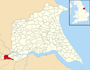
Snaith and Cowick is a special local area in the East Riding of Yorkshire, England. It is called a civil parish. Think of it like a small community or district with its own local council.
This area is about 6 miles (10 km) west of the town of Goole. It covers a space of about 2,400 hectares, which is like 6,000 football fields!
What Makes Up Snaith and Cowick?
The civil parish of Snaith and Cowick is made up of three main places. These are the town of Snaith and two villages, East Cowick and West Cowick. Together, they form this community.
How Many People Live Here?
Every few years, the UK counts how many people live in different areas. This is called a census. In 2011, the census showed that 3,579 people lived in Snaith and Cowick. This was more than in 2001, when 3,028 people lived there. This means more people moved to or were born in the area.
A Look Back in Time
The way local areas are managed has changed over the years. From 1894 to 1974, Snaith and Cowick was part of the Goole Rural District. This was in the West Riding of Yorkshire.
Later, from 1974 to 1996, it became part of the Boothferry district. This district was in a larger area called Humberside. Since 1996, it has been part of the East Riding of Yorkshire.
 | Precious Adams |
 | Lauren Anderson |
 | Janet Collins |

