Snead, Alabama facts for kids
Quick facts for kids
Snead, Alabama
|
|
|---|---|

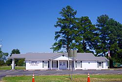
Town Hall
|
|

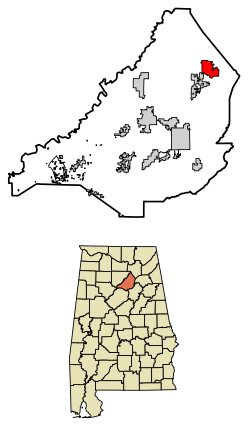
Location of Snead in Blount County, Alabama.
|
|
| Country | United States |
| State | Alabama |
| County | Blount |
| Area | |
| • Total | 5.54 sq mi (14.34 km2) |
| • Land | 5.52 sq mi (14.30 km2) |
| • Water | 0.02 sq mi (0.05 km2) |
| Elevation | 791 ft (241 m) |
| Population
(2020)
|
|
| • Total | 1,032 |
| • Density | 186.96/sq mi (72.19/km2) |
| Time zone | UTC-6 (Central) |
| • Summer (DST) | UTC-5 (CDT) |
| FIPS code | 01-71280 |
| GNIS feature ID | 0127070 |
Snead is a small town located in Blount County, Alabama, United States. In 2020, about 1,032 people lived there. It's a quiet place with a history that goes back to the 1800s.
Contents
A Look Back: Snead's History
Snead was first settled in 1839. It started to grow more in the 1850s. A local businessman named G.W. White built a gristmill nearby. A gristmill is a place where grain is ground into flour.
The town is named after John Snead. He became the first postmaster in 1882. A postmaster manages the local post office. Snead State Community College in Boaz is also named after him. Snead officially became a town in 1966.
Where is Snead?
Snead is located where two main roads meet. These are U.S. Route 278 and Alabama State Route 75.
- US-278 goes east about 26 miles to Gadsden.
- It goes west about 27 miles to Cullman.
- Highway 75 goes northeast about 15 miles to Albertville.
- It goes southwest about 14 miles to Oneonta. Oneonta is the main town in Blount County.
The town is also near the Locust Fork of the Black Warrior River. This river borders the town to the northeast.
Snead covers a total area of about 5.54 square miles (14.34 square kilometers). Most of this area is land. Only a very small part is water.
Who Lives in Snead?
The number of people living in Snead has changed over the years. Here's how the population has grown:
| Historical population | |||
|---|---|---|---|
| Census | Pop. | %± | |
| 1970 | 347 | — | |
| 1980 | 667 | 92.2% | |
| 1990 | 632 | −5.2% | |
| 2000 | 748 | 18.4% | |
| 2010 | 835 | 11.6% | |
| 2020 | 1,032 | 23.6% | |
| U.S. Decennial Census 2013 Estimate |
|||
Snead's Population in 2020
In 2020, there were 1,032 people living in Snead. These people lived in 382 households. A household is a group of people living together in one home. About 251 of these households were families.
Most of the people in Snead were White (84.79%). About 11.05% of the population was Hispanic or Latino.
Snead's Population in 2010
In 2010, Snead had 835 people. There were 374 households in the town. About 25% of these households had children under 18 living there. More than half (51.9%) were married couples.
The average age of people in Snead was about 43.8 years old. About 22.6% of the people were under 18. Another 22.6% were 65 years old or older.
The average income for a household in Snead was about $36,029 per year. For families, the average income was about $41,563 per year.
See also
 In Spanish: Snead para niños
 | Bessie Coleman |
 | Spann Watson |
 | Jill E. Brown |
 | Sherman W. White |

