Sobrado, Galicia facts for kids
Quick facts for kids
Sobrado
|
|||||
|---|---|---|---|---|---|
|
|||||
|
|||||
| Country | |||||
| Autonomous Community | |||||
| Province | A Coruña | ||||
| Comarca | Terra de Melide | ||||
| Government | |||||
| • Type | Concello | ||||
| Area | |||||
| • Total | 120.64 km2 (46.58 sq mi) | ||||
| Elevation | 510 m (1,670 ft) | ||||
| Population
(2018)
|
|||||
| • Total | 1,799 | ||||
| • Density | 14.912/km2 (38.622/sq mi) | ||||
| Demonym(s) | Sobradense (m),Sobradesa (f) | ||||
| Time zone | CET (GMT +1) | ||||
| • Summer (DST) | CEST (GMT +2) | ||||
| Postcode |
15813
|
||||
| Area code(s) | +34 | ||||
| ISO 3166-2 | ES-C | ||||
| Website | http://www.sobrado.es | ||||
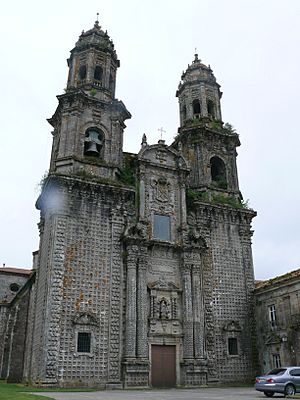
Sobrado is a small town, also called a municipality, located in the province of A Coruña in Galicia, Spain. It has a population of about 1,800 people and covers an area of 121 square kilometers. Sobrado is famous for its old Sobrado Abbey, which is a Trappist monastery. The town is sometimes called Sobrado dos Monxes in Galician or Sobrado de los Monjes in Spanish, but its official name is simply Sobrado.
Exploring Sobrado's Geography
Sobrado's Climate and Nature
Sobrado has a typical European Atlantic climate. This means it is often wet and cool. There is a lot of rain because of its location in the mountains. These mountains block Atlantic storms, causing heavy rainfall. The area gets about 1,400 millimeters of rain each year.
Temperatures in Sobrado can change a lot. The average temperature is around 8.4 °C. In July, temperatures can reach 33 °C. In December, they can drop to -3 °C.
Most of the land in Sobrado is covered by forests. The rest of the land is used for farming. Farmers mainly grow crops for livestock, like grass and corn. Small gardens are found around homes. Greenhouses are also becoming more common in the area.
Mountains and Hills of Sobrado
Sobrado is in a mountain area called the Dorsal Gallega. The eastern and southern parts of the municipality have the highest points. These include the Cova da Serpe mountains and the Corno do Boi hills in the east. In the south, you'll find the Bocelo mountains.
Here, you can see ancient stone structures called megaliths. These include the dolmen of Forno dos Mouros. There are also two large round rocks called "Pena da Moura." People wonder if these rocks were placed there by humans.
These mountain systems are about 750 meters high. Mount Campelo is 806 meters tall, and Pilar mountain is 801 meters tall. They are located near the province border. From these spots, you can enjoy amazing views of the area.
The western parts of Sobrado are lower, ranging from 450 to 600 meters. The mountains turn into smaller hills and valleys. Most of the people in Sobrado live in these lower areas.
Rivers and Waterways
Sobrado's river system has many small rivers. These rivers usually have a low flow of water. This is common for a region with mountain peaks.
The Bocelo mountains are the source of two major rivers in western Galicia. The Mandeo River flows down to the Ria de Betanzos. The Tambre River flows into the estuary of Muros and Noia.
Sobrado's Historic Places
Sobrado Abbey: A Journey Through Time
People believe a monastery was first built here in the 900s by Benedictine monks. By the early 1100s, it was empty.
In 1142, it was reopened as a Cistercian monastery. It was connected to Clairvaux Abbey. The monastery grew strong in the 1100s and 1200s. It even started its own daughter monastery, Valdedios Abbey, in Asturia. Sobrado also helped oversee Monfero Abbey when it joined the Cistercian Order.
After a period of decline, Sobrado was the first abbey in Galicia to join the Castilian Cistercian Congregation in 1498.
A grand new Baroque abbey church was finished in 1708. Most of the other monastery buildings were also rebuilt around this time.
In 1835, the government closed down monasteries. This was part of a plan by Mendizábal. Sobrado Abbey was abandoned and its buildings started to fall apart.
In 1954, Trappist monks from Viaceli Abbey in Cóbreces, west of Cantabria, began to rebuild it. They had already restored Huerta Abbey in 1929. In 1966, a new Trappist community moved into the monastery.
Roman Camp of Cidadela: An Ancient Military Base
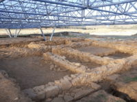
This ancient Roman camp is located on a flat area about 480 meters high. It is surrounded by the Serra da Corda mountain, which ranges from 522 to 601 meters tall. The camp was built here for strategic reasons. It helped the Romans control the path of the Roman road to "Lucus Augusti" (Lugo).
The camp is shaped like a rectangle with rounded corners. It is 172 meters long and 140 meters wide. This covers an area of 2.40 hectares. This size was suitable for a military unit of five thousand soldiers. The entire camp was protected by a wall and a moat. There were also several control points near the camp.
Many items have been found at the camp. These include coins from the time of Domitian (86 AD) to Claudius II (270 AD). A wide variety of glass, bronze, and iron objects have also been found. There are also pieces of pottery used for building.
Sobrado's Natural Wonders
Sobrado has many beautiful natural areas. It has numerous rivers and lakes. There is also a wet area that is important for Europe. The region is full of forests with oak, chestnut, and birch trees.
The Lagoon of Sobrado
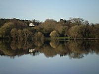
The Lagoon of Sobrado was created by people. It was built between 1500 and 1530 by monks. They dammed small rivers to get water for their fields. They also used the water to power mills and for fishing.
The lagoon is round and covers about 10 hectares. Its average depth is 1.5 meters, but it can be up to 4.5 meters deep. It is located at an altitude of 510 meters. Its water level changes by about 20 centimeters each year.
The lagoon is a great example of a lake ecosystem. You can find frogs, ducks, dragonflies, otters, and cormorants here. It is the only place in the Iberian Peninsula where a special type of alga, "Nitella-Flexilis," has been found.
Around the lagoon, you can see a typical "tree-gallery" forest. This includes birch, alder, ash, and willow trees. Beyond this, you'll find the Galician farming landscape. It has fields, crops, and more forests. This area provides shelter and food for marsh wildlife. It is also a wonderful place for learning and enjoying nature.
The "Casa do Gado" Oak Forest
This is a beautiful oak forest located above the town of Sobrado. You can also find chestnut, mistletoe, and birch trees here. In the 1980s, a movie was filmed in this forest.
The movie is called The Living Forest (El Bosque Animado). It is based on a novel by a Galician writer named Wenceslao Fernandez Florez.
Galicia's Second Oldest Oak Tree
In the village of Portacal (Cumbraos), there is an oak tree. It is ranked as the second oldest oak in Galicia. This ranking was given by the SGHN Galicia (Galician Society of Natural History).
See also
 In Spanish: Sobrado (La Coruña) para niños
 | Calvin Brent |
 | Walter T. Bailey |
 | Martha Cassell Thompson |
 | Alberta Jeannette Cassell |


