Socotá facts for kids
Quick facts for kids
Socotá
|
|||
|---|---|---|---|
|
Municipality and town
|
|||
|
|||

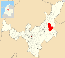
Location of the municipality and town of Socotá in the Boyacá Department of Colombia
|
|||
| Country | |||
| Department | Boyacá Department | ||
| Province | Valderrama Province | ||
| Founded | 19 January 1602 | ||
| Founded by | Gonzalo Sánchez de Flandes | ||
| Area | |||
| • Municipality and town | 600.11 km2 (231.70 sq mi) | ||
| • Urban | 1 km2 (0.4 sq mi) | ||
| Elevation | 2,443 m (8,015 ft) | ||
| Population
(2015)
|
|||
| • Municipality and town | 9,812 | ||
| • Density | 16.3503/km2 (42.3472/sq mi) | ||
| • Urban | 1,095 | ||
| Time zone | UTC-5 (Colombia Standard Time) | ||
| Website | Official website: http://www.socota-boyaca.gov.co/ | ||
Socotá is a town and a municipality in Colombia. It is located in the Boyacá Department, which is a part of Colombia. Socotá is found in the Valderrama Province.
This town is nestled in the Eastern Ranges of the Andes mountains in Colombia. The main part of Socotá sits high up, about 2,443 metres (8,015 ft) above sea level. It is about 134 kilometres (83 mi) away from Tunja, which is the capital city of the Boyacá Department.
Socotá shares its borders with several other towns. To the north, it borders Jericó and Sativanorte. To the south, you'll find Pisba and Mongua. On the east side, it borders Chita and Támara in the Casanare Department. Finally, to the west, it borders Sativasur, Tasco, Socha, and Gámeza.
Contents
What Does the Name Socotá Mean?
The name Socotá comes from the ancient Chibcha language. It has two possible meanings:
- "Land of the Sun and farmfields"
- "Good harvest"
A Look Back at Socotá's History
Before the Spanish arrived, the area where Socotá is now was part of a group of communities called the Muisca Confederation. This was a loose group of native people. Socotá was the most northeastern part of this confederation. It was likely ruled by either the iraca from Sugamuxi or the Tundama from Tundama.
The modern town of Socotá was officially started on January 19, 1602. It was founded by a person named Gonzalo Sanchez de Flandes.
What Socotá's Economy Is Like
The main way people in Socotá make a living is through livestock farming. This means they raise animals like cows, sheep, or pigs. There is also some coal mining that happens, but it is a smaller part of the economy.
Places and Things Named After Socotá
- Socotá Formation: This is a special type of rock layer found in the area. It is made of sandstone and shale and formed a long time ago, during the Lower Cretaceous period.
Socotá's Climate
Socotá has a cool climate because it is located high in the mountains. The weather can change quite a bit throughout the year.
| Climate data for Socotá (Cardon El), elevation 3,590 m (11,780 ft), (1981–2010) | |||||||||||||
|---|---|---|---|---|---|---|---|---|---|---|---|---|---|
| Month | Jan | Feb | Mar | Apr | May | Jun | Jul | Aug | Sep | Oct | Nov | Dec | Year |
| Mean daily maximum °C (°F) | 10.8 (51.4) |
10.8 (51.4) |
10.7 (51.3) |
9.8 (49.6) |
9.5 (49.1) |
8.6 (47.5) |
8.0 (46.4) |
8.1 (46.6) |
8.5 (47.3) |
9.2 (48.6) |
10.0 (50.0) |
10.6 (51.1) |
9.5 (49.1) |
| Daily mean °C (°F) | 6.6 (43.9) |
6.5 (43.7) |
6.6 (43.9) |
6.6 (43.9) |
6.5 (43.7) |
5.9 (42.6) |
5.4 (41.7) |
5.4 (41.7) |
5.7 (42.3) |
6.2 (43.2) |
6.6 (43.9) |
6.6 (43.9) |
6.2 (43.2) |
| Mean daily minimum °C (°F) | 2.9 (37.2) |
3.0 (37.4) |
3.5 (38.3) |
4.1 (39.4) |
4.0 (39.2) |
3.5 (38.3) |
3.1 (37.6) |
3.2 (37.8) |
3.3 (37.9) |
3.6 (38.5) |
3.7 (38.7) |
3.1 (37.6) |
3.4 (38.1) |
| Average precipitation mm (inches) | 33.3 (1.31) |
60.6 (2.39) |
89.0 (3.50) |
207.7 (8.18) |
301.1 (11.85) |
379.7 (14.95) |
446.0 (17.56) |
367.7 (14.48) |
251.8 (9.91) |
196.8 (7.75) |
114.9 (4.52) |
61.0 (2.40) |
2,509.5 (98.80) |
| Average precipitation days (≥ 1.0 mm) | 9 | 13 | 18 | 24 | 27 | 28 | 29 | 30 | 28 | 27 | 22 | 15 | 266 |
| Average relative humidity (%) | 87 | 87 | 90 | 95 | 96 | 97 | 97 | 97 | 96 | 94 | 93 | 89 | 93 |
| Source: Instituto de Hidrologia Meteorologia y Estudios Ambientales | |||||||||||||
See also
 In Spanish: Socotá para niños
 | Dorothy Vaughan |
 | Charles Henry Turner |
 | Hildrus Poindexter |
 | Henry Cecil McBay |


