
South Bay Interchange facts for kids
Quick facts for kids South Bay Interchange |
|
|---|---|
| Location | |
| South Bay, Boston, Massachusetts | |
| Coordinates: | 42°20′46″N 71°03′36″W / 42.346°N 71.060°W |
| Roads at junction: |
|
| Construction | |
| Constructed: | 1997–2003 |
| Opened: | 2003 |
| Maintained by: | Massachusetts Department of Transportation |
| Map | |
| Lua error in Module:Infobox_road/map at line 15: attempt to index field 'wikibase' (a nil value). | |
The South Bay Interchange is a very important road connection in downtown Boston, Massachusetts, in the USA. An interchange is like a giant puzzle of roads that lets cars move easily from one highway to another. This interchange connects Interstate 90 (also known as the Mass Pike Extension) with Interstate 93. It also connects with US 1 and MA 3. These roads all come together just south of the Thomas P. O'Neill Jr. Tunnel.
This big road system takes up a large area called the South Bay parcel. This area is about 10 acres (40,000 square meters) and is located between Boston's Chinatown and the Leather District. It's surrounded by Kneeland Street, Hudson Street, the main part of the Massachusetts Turnpike, and the main part of Interstate 93. The Massachusetts Department of Transportation (MassDOT) owns this land. Even though there were plans to build a tall office building here, that project has not happened.
How the South Bay Area Changed Over Time
The land where the South Bay Interchange is now, along with the nearby Chinatown and Leather District neighborhoods, was once part of the ocean! This area was originally a marshy bay called South Cove. In 1833, people filled in this part of the bay with dirt. This was done by a company called the South Cove Corporation.
They built a special station where trains and ships could meet, as part of the Boston and Worcester Railroad. Along with this, they built homes and businesses. For many years, especially in the 1800s and early 1900s, this area was full of rail yards. These yards were where trains coming into Boston from the south and west would stop.
The train yards brought many leather and clothing businesses to the area. This is why the nearby neighborhood is called the Leather District. The railroad also became a way for new people to arrive in Boston. Starting in the late 1800s, many Asian immigrants, especially Chinese people, came through this area.
In the 1950s, the Massachusetts Highway Department built a big highway called the John F. Fitzgerald Expressway (also known as the Central Artery). This highway took up much of the old train yard land. Later, the South Bay Interchange was built to connect the Central Artery to the Massachusetts Turnpike. This whole intersection was rebuilt as part of a huge project called the Big Dig. Now, there are also tunnels that go from here to South Boston and Logan Airport.
Building the Interchange
Construction on the South Bay Interchange started in the late 1990s. It was a very important part of the Big Dig project. Engineers used clever methods to build it without stopping traffic. For example, they froze the soil and used a technique called "tunnel jacking." This helped them keep the nearby subway, freight trains, and commuter trains running smoothly.
The name "South Bay" comes from how the area looked before the 1800s. Back then, it was a bay with marshes and salty water that connected to Boston Harbor. People filled in this area with dirt from nearby high ground to create new land.
Images for kids
-
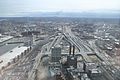
Overlooking South Bay Interchange toward the south-southwest from One Financial Center in Boston, with the Great Blue Hill visible in the background
-
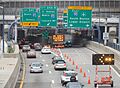
Traffic detoured onto I-93 at the South Bay Interchange after the Big Dig ceiling collapse.


