
Great Blue Hill facts for kids
Quick facts for kids Great Blue Hill |
|
|---|---|

View of Great Blue Hill from neighbouring Signal Hill
|
|
| Highest point | |
| Elevation | 635 ft (193.5 m) |
| Prominence | 483 ft (147 m) |
| Geography | |
| Location | Norfolk County, Massachusetts |
| Parent range | Blue Hills |
| Topo map | USGS Norwood |
Great Blue Hill is a famous hill in Massachusetts. It stands 635 feet (194 meters) tall. You can find it in the Blue Hills Reservation. This hill is located near Milton, Randolph, and Canton. It is about 10 miles (16 km) south of downtown Boston. Great Blue Hill is the highest point in Norfolk County. It is also the highest spot in the wider Greater Boston area.
Early English settlers gave the hill its name. They saw its bluish color from their ships. This blue color comes from a mineral called Riebeckite in the rocks. The eastern side of the Blue Hills faces the ocean. This area was once used for mining "blue granite."
Great Blue Hill was an important landmark for Native Americans. The local tribe was known as the "people at the large hill." Their name was Massachuseuck. The English later called them the Massachusetts. This name eventually became the name of the state itself.
Exploring Great Blue Hill's Geography
Great Blue Hill is a special place because of where it is located. It is the highest point in the Greater Boston area. It is also the highest spot in Norfolk County. Plus, it is the tallest point within 10 miles (16 km) of the Atlantic Ocean coast. This is true for any land south of central Maine.
Water Flow Around the Hill
The water from the north and west sides of Great Blue Hill flows into the Neponset River. From there, it goes into Boston Harbor. Water from the south and east sides of the hill flows into the Blue Hill River. This river then joins the Farm River. After that, it flows into the Monatiquot River and the Weymouth Fore River. Finally, this water also reaches Boston Harbor.
The Blue Hill Meteorological Observatory
Because of its height and location, Great Blue Hill was chosen for a special weather station. An American meteorologist named Abbott Lawrence Rotch picked this spot. He built the Blue Hill Meteorological Observatory here in 1885. Rotch did important studies about the atmosphere from this observatory. Even today, weather information is still collected at this site.
From the Eliot Tower at the top of the hill, you can see far and wide. You can see the city of Boston. You can also see many of the hills around Milton and Canton.
Fun Activities at Great Blue Hill
Great Blue Hill is a very popular place for outdoor activities. Many people enjoy hiking here. They love the beautiful trails and amazing views. It is also easy to get to from the city.
Skiing and Hiking Trails
You can even go alpine skiing at the Blue Hills Ski Area. This area has eight trails. There is a chairlift and two surface lifts to take you up the hill.
The main road to the top is called Summit Road. It is a steep, paved road. Cars are not allowed on this road, except for people who work at the weather observatory. However, hikers and cyclists are welcome to use the road.
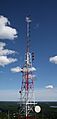
Radio and TV Stations on the Hill
Some well-known Boston radio and television stations use Great Blue Hill. For example, WGBH (FM) and WGBH-TV got their call letters from this hill. It was where their original FM and TV transmitters were located. WGBH (FM) still broadcasts from the hill today.
Other stations also use the hill for their signals:
- WZRM, an FM station, moved its transmitter to Great Blue Hill in 2005. This helped it serve Boston better.
- The NOAA Weather Radio All Hazards station, KHB35, also broadcasts from the top of the hill. This station provides weather alerts for Greater Boston and nearby coastal waters.
A Famous Prank
In 1980, Great Blue Hill was part of a funny prank. A news station, WNAC-TV, reported that a volcano was erupting on the hill! Of course, it was just a joke.
Wildlife at Great Blue Hill
Great Blue Hill and the Blue Hills Reservation are home to some rare animals. It is one of the last places in Greater Boston where you might find the timber rattlesnake and the copperhead.
These snakes are very rare in Massachusetts. People almost never see them. Both types of snakes are considered endangered. This means it is against the law to bother them, kill them, collect them, or keep them as pets. It is important to protect these special creatures.
Images for kids
-
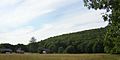
The hill from Brookwood Farm
-
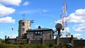
The weather observatory
-
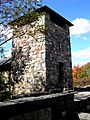
Eliot Memorial Bridge and Tower
-
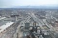
The South Bay interchange (looking south) to the Southeast Expressway with Great Blue Hill visible in the background
-
Radio transmitter of WGBH (FM)


.jpg)
