Randolph, Massachusetts facts for kids
Quick facts for kids
Randolph, Massachusetts
|
||
|---|---|---|
|
City
|
||

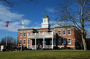
Randolph Town Hall
|
||
|
||
| Motto(s):
Latin: Fari Quae Sentiat
"To Say What One Feels" |
||

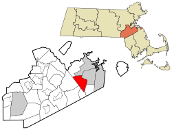
Location in Norfolk County in Massachusetts
|
||
| Country | ||
| State | ||
| County | Norfolk | |
| Settled | 1710 | |
| Incorporated | 1793 (T) 2010 (C) | |
| Government | ||
| • Type | Council-manager | |
| Area | ||
| • Total | 10.5 sq mi (27.2 km2) | |
| • Land | 10.1 sq mi (26.1 km2) | |
| • Water | 0.4 sq mi (1.1 km2) | |
| Elevation | 184 ft (56 m) | |
| Population
(2020)
|
||
| • Total | 34,984 | |
| • Density | 3,332/sq mi (1,286.2/km2) | |
| Time zone | UTC−5 (Eastern) | |
| • Summer (DST) | UTC−4 (Eastern) | |
| ZIP Code |
02368
|
|
| Area code(s) | 781/339 | |
| FIPS code | 25-55955 | |
| GNIS feature ID | 0618328 | |
| Randolph charter of 2009 | ||
Randolph is a lively city in Norfolk County, Massachusetts, United States. It's a suburban community, meaning it's a town near a larger city, where many people live. In 2020, about 34,984 people called Randolph home. The city uses a special way of governing called a council-manager system. This means a city council makes decisions, and a city manager helps run the daily operations. Randolph is one of a few places in Massachusetts that are officially cities but still like to be called "The town of" in their official name.
Contents
History of Randolph
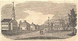
The area where Randolph is located was once known as Cochaticquom by the local Cochato tribes. The town officially became its own community in 1793. Before that, it was part of Braintree. The town was named after Peyton Randolph, who was the first president of the Continental Congress.
For a long time, Randolph was famous for making shoes. Many popular shoe styles were created here. In the early days, farmers would make shoes and boots to earn extra money. Over time, this grew into a huge industry. It brought many workers to Randolph from different places like New England, Canada, Ireland, Italy, and Eastern Europe. By the mid-1800s, Randolph was a top producer of boots, sending them all over the world.
As the shoe industry changed, Randolph also changed. It became a place where people lived and worked in other types of jobs, like light manufacturing and service industries. Because Randolph is close to major roads and cities, many families from Boston and other areas moved here. They enjoyed living in Randolph while working in the wider metropolitan area.
Starting in the 1950s, Randolph saw its Jewish community grow significantly. Many Jewish families moved from Boston neighborhoods like Dorchester and Mattapan to Randolph. This community added to the town's culture with special shops and synagogues.
A cool fact about Randolph is that it inspired the Great American Smokeout. This is a national event where people are encouraged to stop smoking for a day. The idea came from a guidance counselor at Randolph High School in 1969. He suggested that if students saved money from not smoking, it could go towards a college scholarship fund. The students and the local Rotary Club supported this idea, and it became a national event in 1977.
Geography of Randolph
Randolph covers about 10.5 square miles (27.2 square kilometers). Most of this area is land, with a small part being water. The town has two rivers, the Cochato River and the Blue Hill River. These rivers eventually flow into the Neponset River.
| Climate data for Blue Hills Reservation (Blue Hill Meteorological Observatory), 1891−2010 normals, extremes 1885−present | |||||||||||||
|---|---|---|---|---|---|---|---|---|---|---|---|---|---|
| Month | Jan | Feb | Mar | Apr | May | Jun | Jul | Aug | Sep | Oct | Nov | Dec | Year |
| Record high °F (°C) | 68 (20) |
68 (20) |
89 (32) |
94 (34) |
94 (34) |
99 (37) |
100 (38) |
101 (38) |
99 (37) |
88 (31) |
81 (27) |
74 (23) |
101 (38) |
| Mean daily maximum °F (°C) | 33.6 (0.9) |
34.8 (1.6) |
43.4 (6.3) |
54.9 (12.7) |
66.3 (19.1) |
74.6 (23.7) |
80.0 (26.7) |
77.9 (25.5) |
70.9 (21.6) |
60.5 (15.8) |
48.8 (9.3) |
37.4 (3.0) |
56.9 (13.8) |
| Daily mean °F (°C) | 25.7 (−3.5) |
26.4 (−3.1) |
34.4 (1.3) |
44.7 (7.1) |
55.3 (12.9) |
64.1 (17.8) |
69.7 (20.9) |
68.1 (20.1) |
61.2 (16.2) |
51.1 (10.6) |
40.6 (4.8) |
29.8 (−1.2) |
47.6 (8.7) |
| Mean daily minimum °F (°C) | 18.4 (−7.6) |
18.9 (−7.3) |
27.0 (−2.8) |
36.5 (2.5) |
46.4 (8.0) |
55.4 (13.0) |
61.5 (16.4) |
60.3 (15.7) |
53.6 (12.0) |
43.4 (6.3) |
33.7 (0.9) |
22.9 (−5.1) |
39.8 (4.3) |
| Record low °F (°C) | −16 (−27) |
−21 (−29) |
−5 (−21) |
6 (−14) |
27 (−3) |
36 (2) |
44 (7) |
39 (4) |
28 (−2) |
21 (−6) |
5 (−15) |
−19 (−28) |
−21 (−29) |
| Average precipitation inches (mm) | 4.24 (108) |
3.95 (100) |
4.61 (117) |
4.06 (103) |
3.70 (94) |
3.69 (94) |
3.64 (92) |
4.08 (104) |
3.94 (100) |
3.97 (101) |
4.36 (111) |
4.39 (112) |
48.63 (1,236) |
| Average snowfall inches (cm) | 16.0 (41) |
16.1 (41) |
11.7 (30) |
2.9 (7.4) |
0.1 (0.25) |
0.0 (0.0) |
0.0 (0.0) |
0.0 (0.0) |
0.0 (0.0) |
0.3 (0.76) |
2.6 (6.6) |
11.4 (29) |
61.1 (156.01) |
| Mean monthly sunshine hours | 132.1 | 146.7 | 174.0 | 185.6 | 220.2 | 231.8 | 258.1 | 242.5 | 204.1 | 182.1 | 133.3 | 125.9 | 2,236.4 |
| Percent possible sunshine | 46.3 | 50.9 | 48.5 | 47.9 | 50.4 | 52.7 | 58.0 | 58.7 | 56.7 | 55.1 | 47.0 | 45.9 | 51.5 |
| Source: Blue Hill Observatory & Science Center | |||||||||||||
Population and Diversity
| Historical population | ||
|---|---|---|
| Year | Pop. | ±% |
| 1850 | 4,741 | — |
| 1860 | 5,760 | +21.5% |
| 1870 | 5,642 | −2.0% |
| 1880 | 4,027 | −28.6% |
| 1890 | 3,946 | −2.0% |
| 1900 | 3,998 | +1.3% |
| 1910 | 4,301 | +7.6% |
| 1920 | 4,756 | +10.6% |
| 1930 | 6,553 | +37.8% |
| 1940 | 7,634 | +16.5% |
| 1950 | 9,982 | +30.8% |
| 1960 | 18,900 | +89.3% |
| 1970 | 27,035 | +43.0% |
| 1980 | 28,218 | +4.4% |
| 1990 | 30,093 | +6.6% |
| 2000 | 30,963 | +2.9% |
| 2010 | 32,112 | +3.7% |
| 2020 | 34,984 | +8.9% |
| 2022* | 34,530 | −1.3% |
| * = population estimate. Source: United States Census records and Population Estimates Program data. |
||
In 2020, Randolph had a population of 34,984 people. The city is known for its diverse community, with people from many different backgrounds living here. For example, students in Randolph's elementary schools come from various heritages, including African, Latino, Caucasian, and East Asian. This mix of cultures makes Randolph a vibrant and interesting place to live.
The average household in Randolph had about 2.75 people. The median age in the town was 38 years old. This means half the population was younger than 38, and half was older.
Arts and Culture
Turner Free Library
The Turner Free Library is Randolph's public library. It's a place where everyone can borrow books, use computers, and learn new things. The library was started in 1874. It was named after the Turner family, who generously donated the building, land, and money to the town. They wanted to make sure Randolph had a free public library for everyone. The library officially opened its doors in 1875.
Historic Places to Explore
Randolph has several places that are listed on the National Register of Historic Places. These are important sites that tell us about the town's past. Some of these include:
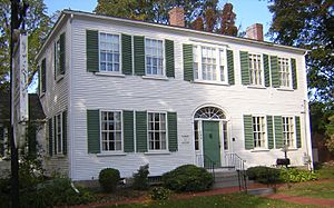
- The Jonathan Belcher House, built in 1806.
- Stetson Hall, built in 1842.
- The Ponkapoag Camp of Appalachian Mountain Club.
- The Gills Farm Archaeological District.
Government in Randolph
Randolph's government has changed over the years. It started with an open town meeting, where all citizens could gather to make decisions. Later, it moved to a representative town meeting. In this system, citizens elected representatives to make decisions for them. In 2010, Randolph adopted a new system called a council-manager government. Now, a city council makes policies, and a city manager handles the day-to-day running of the city. The current Council President is William Alexopoulos, and the City Manager is Brian P. Howard. Citizens participate in local government by voting for their leaders.
Education in Randolph
The Randolph Public School District manages education in the city. Randolph has several schools for different age groups:
- AIM Academy
- John F. Kennedy Elementary School
- Margaret L. Donovan Elementary School
- Martin E. Young Elementary School
- North Randolph Elementary School
- Randolph Community Middle School
- Randolph High School
Getting Around Randolph (Infrastructure)
Major Roads
Randolph is connected by several important roads, making it easy to travel to and from the city. These include:
- Interstate 93
- U.S. Route 1
- Massachusetts Route 24 (also known as the Fall River Expressway)
- Massachusetts Route 28
- Massachusetts Route 139
Train Service
The Holbrook/Randolph station offers train service. It's part of the Fall River/New Bedford Line of the MBTA Commuter Rail. This allows people to travel by train to other areas.
Bus Service
Bus services are available through the Massachusetts Bay Transportation Authority and the Brockton Area Transit Authority. These buses help people get around Randolph and to nearby towns.
Airport Nearby
For air travel, the Norwood Memorial Airport is located nearby.
Notable People from Randolph
Many interesting people have connections to Randolph. Here are a few:
- Audie Cornish, a well-known journalist.
- Danny Davis, a famous bandleader and music producer.
- Mary E. Wilkins Freeman, an author.
- Rod Langway, a Hall of Fame hockey player.
- Shabazz Napier, an NBA basketball player.
- Scott D. Tingle, a NASA astronaut.
- Touré, a writer and television personality.
See also
 In Spanish: Randolph (Massachusetts) para niños
 | Dorothy Vaughan |
 | Charles Henry Turner |
 | Hildrus Poindexter |
 | Henry Cecil McBay |


