
South Coogee, New South Wales facts for kids
Quick facts for kids South CoogeeSydney, New South Wales |
|||||||||||||||
|---|---|---|---|---|---|---|---|---|---|---|---|---|---|---|---|

Shopping strip, Malabar Road
|
|||||||||||||||
| Population | 5,502 (2016 census) | ||||||||||||||
| Postcode(s) | 2034 | ||||||||||||||
| Location | 9 km (6 mi) south-east of Sydney CBD | ||||||||||||||
| LGA(s) | City of Randwick | ||||||||||||||
| State electorate(s) | Coogee | ||||||||||||||
| Federal Division(s) | Kingsford Smith | ||||||||||||||
|
|||||||||||||||

South Coogee is a coastal area in the eastern part of Sydney, New South Wales, Australia. It is about 9 kilometres south-east of the main city centre of Sydney. South Coogee is part of the City of Randwick, which is a local council area.
The suburb of Coogee is just north of South Coogee. Other nearby areas include Kingsford and Maroubra.
Contents
What's in a Name? The History of Coogee
The name "Coogee" might come from an Aboriginal word. Some people think it's from koojah, which means "smelly place" or "stinking seaweed". This could refer to the smell of seaweed that sometimes washes up on the beach. Even today, lots of seaweed can appear, but it's usually cleaned up quickly.
Early visitors in the 1820s weren't sure what "Coogee" truly meant. They also heard another name, "Bobroi," for the area. Some clues suggest that "Coogee" might have originally been the name for the bay just north of Coogee Beach, which is now called Gordon's Bay.
Coogee officially became a village in 1838. It grew slowly until 1902, when electric trams connected it to the city. This made it much easier for people to travel to and from the area.
Randwick Cemetery: A Place of History
Before the 1870s, the Randwick area only had one cemetery at St Jude's Church. Another cemetery, Rookwood, was also used, but it was too far away for many people. Local residents asked for a new cemetery closer to home.
In 1872, the Randwick Council was allowed to buy land for a second cemetery. This land was in what is now South Coogee. The new cemetery, called Long Bay Cemetery, opened in July 1874. Many well-known people are buried here, including:
- Ernest Broughton: A mayor of Ashfield and a member of the New South Wales Parliament.
- The Hannan family: They published a local newspaper called the Randwick Coogee Weekly.
- Darby Munro: A very famous jockey.
- Sir John See: He was the mayor of Randwick twice and later became the 14th Premier of New South Wales from 1901 to 1904.
- Charles Henry Streeton: He was the father of the famous painter, Sir Arthur Ernest Streeton.
- The Veness family: They were business people, including Fred Veness, who was the Randwick Postmaster for many years.
Who Lives in South Coogee?
The 2016 census counted 5,502 people living in South Coogee.
- About 2.2% of the people were Aboriginal and Torres Strait Islander.
- Most people (61.3%) were born in Australia. Other common birthplaces included England (5.1%), South Africa (2.0%), and China (1.9%).
- English was the main language spoken at home by 70.0% of residents. Other languages included Greek (4.1%), Russian (3.0%), and Mandarin (2.2%).
- For religion, the most common answers were Catholic (29.2%) and No Religion (25.8%).
Schools in South Coogee
South Coogee has its own primary school, called South Coogee Public School.
Churches in the Area
- South Coogee Anglican Church is a place of worship in the suburb.
Getting Around South Coogee: Transport
Buses are the main way to get around South Coogee. They run along Malabar Road.
- Route 353: Travels north to Bondi Junction (passing through Coogee) and south to Eastgardens (via Maroubra Junction).
- Routes 376 and 377: Go north to the City (through Randwick Junction) and south to Maroubra Beach.
Important Places and Landmarks
- Latham Park: This is a large outdoor area with lots of space for sports. It has fields for football, cricket pitches, tennis courts, and bowls greens. Next to it is Endeavour House, a building used by the Royal Australian Navy.
- Shopping Strips: There's a small group of shops on Malabar Road, near Randwick Cemetery. Another set of shops is about one kilometre further south on Malabar Road, at Torrington Road.
- Lurline Bay: This is a quiet, rocky bay located between Coogee and Maroubra Beaches. It's surrounded by natural headlands shaped by the weather. You can only reach this small bay by walking along the coastal path from Seaside Parade (to the north) or Marine Parade (if you're coming from Maroubra Beach).
Images for kids
-
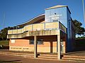
Jeffrey Sayle Pavilion, Latham Park
-
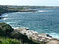
View from Coastal Walk, looking towards Coogee Beach
-
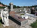
Randwick Cemetery, Malabar Road
-
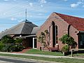
St Paul's Anglican Church, Gregory Street


