
South Fork Humboldt River facts for kids
Quick facts for kids South Fork Humboldt River |
|
|---|---|

South Fork and its source, the Ruby Mountains,
|
|

Location of the South Fork of the Humboldt River within Nevada
|
|
| Country | United States |
| State | Nevada |
| County | Elko |
| Physical characteristics | |
| Main source | 5,775 ft (1,760 m) |
| River mouth | Humboldt River 4,998 ft (1,523 m) 40°46.3′N 115°53.3′W / 40.7717°N 115.8883°W |
| Length | 38 mi (61 km) |
| Basin features | |
| River system | Humboldt River |
The South Fork Humboldt River is a river in Elko County, Nevada, United States. It is a branch of the larger Humboldt River.
About the River
The South Fork Humboldt River starts in the Ruby Mountains in northeastern Nevada. Its source is a group of canyons on the western side of these mountains. These canyons include Echo, Box, Kleckner, and others.
The streams from these canyons join together. This happens near the town of Lee. This area is part of the tribal lands of the Te-Moak tribe of the Western Shoshone people.
The river then flows northwest. It meets Huntington Creek and passes through an old area called Twin Bridges. Later, it flows into the South Fork Reservoir. This reservoir is part of the State Park. The South Fork Dam was built here in 1988.
South Fork Canyon
After the reservoir, the river goes through South Fork Canyon. Here, it is joined by Tenmile and Dixie creeks. This canyon is famous for a historical event.
On September 25, 1846, the Donner Party passed through this canyon. They were a group of pioneers traveling west. This spot marked the end of their journey on the Hastings Cutoff. They then rejoined the main California Trail.
Where the River Ends
The South Fork Humboldt River is about 38 miles (61 kilometers) long. It eventually flows into the main Humboldt River. This meeting point is about 7 miles (11 kilometers) southwest of the city of Elko.
Images for kids
-
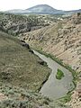
South Fork Canyon, looking south

