South Gorin, Missouri facts for kids
Quick facts for kids
South Gorin, Missouri
|
|
|---|---|

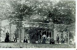
The American Hotel, one of two in Gorin. Circa 1900.
|
|

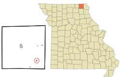
Location of South Gorin, Missouri
|
|
| Country | United States |
| State | Missouri |
| County | Scotland |
| Area | |
| • Total | 0.20 sq mi (0.53 km2) |
| • Land | 0.20 sq mi (0.53 km2) |
| • Water | 0.00 sq mi (0.00 km2) |
| Elevation | 702 ft (214 m) |
| Population
(2020)
|
|
| • Total | 62 |
| • Density | 305.42/sq mi (118.05/km2) |
| Time zone | UTC-6 (Central (CST)) |
| • Summer (DST) | UTC-5 (CDT) |
| FIPS code | 29-68870 |
| GNIS feature ID | 2397666 |
South Gorin is a small city in Scotland County, Missouri, United States. In 2020, about 62 people lived there. The city was first called "Gorin," but its name was later changed to South Gorin. However, the local post office is still known as Gorin.
Contents
History of South Gorin
Gorin was started in 1857. It was named after Reverend M.G. Gorin and Major J.H.M. Gorin. These men were among the first settlers in the area.
The town grew a lot because of the Atchison, Topeka & Santa Fe Railroad. This railroad was built nearby in the 1880s. A train station was built in Gorin, and the town began to grow steadily.
By 1913, Gorin became the second-largest town in Scotland County. It had many businesses. There were two banks and two hotels. You could also find grocery stores, drug stores, and hardware stores. Restaurants and a farm equipment dealer were also present. A factory in town made wagons and buggies. For several years, a weekly newspaper called the Gorin Argus was published.
The Prairie Oil & Gas Company, part of Standard Oil, built a pumping station there. This station was for their cross-country oil pipeline. In 1907, a new school building was built in Gorin. Students from elementary grades up to tenth grade attended this school. It was used for many decades before joining the Scotland County R-1 school district.
Geography of South Gorin
South Gorin is located at 40°21'34" North and 92°1'24" West. These numbers help us find its exact spot on a map.
The United States Census Bureau says the city covers about 0.20 square miles (0.53 square kilometers). All of this area is land.
Population Changes in South Gorin
| Historical population | |||
|---|---|---|---|
| Census | Pop. | %± | |
| 1900 | 319 | — | |
| 1910 | 746 | 133.9% | |
| 1920 | 426 | −42.9% | |
| 1930 | 388 | −8.9% | |
| 1940 | 314 | −19.1% | |
| 1950 | 303 | −3.5% | |
| 1960 | 279 | −7.9% | |
| 1970 | 220 | −21.1% | |
| 1980 | 212 | −3.6% | |
| 1990 | 130 | −38.7% | |
| 2000 | 143 | 10.0% | |
| 2010 | 91 | −36.4% | |
| 2020 | 62 | −31.9% | |
| U.S. Decennial Census | |||
South Gorin Population in 2010
In 2010, a census counted 91 people living in South Gorin. There were 44 households and 25 families. A household is a group of people living together.
The city had about 455 people per square mile (175.7 people per square kilometer). There were 65 housing units in total. All residents were White.
About 18.2% of households had children under 18. Most households (43.2%) were not families. This means they were individuals living alone or groups of unrelated people. About 40.9% of all households were just one person. About 15.9% of households had someone aged 65 or older living alone.
The average household had 2.07 people. The average family had 2.80 people. The median age in the city was 50.3 years old. About 15.4% of residents were under 18. About 26.4% were 65 or older. The population was 52.7% male and 47.3% female.
Transportation in South Gorin
The Southwest Chief train, run by Amtrak, passes through South Gorin. This train travels between Los Angeles and Chicago. It uses the BNSF tracks. However, the train does not stop in South Gorin.
The closest train station is in La Plata. This station is about 49 miles (79 km) southwest of South Gorin.
Notable People from South Gorin
- Ella Ewing - She was known as "The Missouri Giantess." She was the world's tallest woman during her time. She lived near Gorin until she passed away in 1913.
- Sedona Schnebly (1877 - 1950) - The city of Sedona, Arizona was named after her.
See also
 In Spanish: South Gorin (Misuri) para niños
 | Selma Burke |
 | Pauline Powell Burns |
 | Frederick J. Brown |
 | Robert Blackburn |

