
South Havra facts for kids
| Norse name | Hafrey |
|---|---|
| Meaning of name | "Ewe Island" |
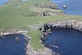
 Aerial view of South Havra |
|
| OS grid reference | HU360268 |
| Coordinates | 60°02′N 1°21′W / 60.03°N 1.35°W |
| Physical geography | |
| Island group | Shetland |
| Area | 59 hectares (0.23 sq mi) |
| Area rank | 183= |
| Highest elevation | 42 metres (138 ft) |
| Administration | |
| Sovereign state | United Kingdom |
| Country | Scotland |
| Council area | Shetland Islands |
| Demographics | |
| Population | 0 |
South Havra, also known as Sooth Haevra in Scots or Hafrey in Old Norse, is a small, uninhabited island. It is located in the Scalloway Islands, which are part of Shetland, Scotland. The name "Hafrey" means "Ewe Island," suggesting that sheep might have been important here long ago.
Contents
Exploring South Havra's Location and Rocks
South Havra is found south of another island called Burra. It also lies to the west of the southern part of the Mainland of Shetland.
What is South Havra Made Of?
The rocks that make up South Havra are a mix of different types. These include "epidiotic syenite," which is a kind of rock similar to granite. There are also "undifferentiated schist and gneiss," which are types of metamorphic rocks. Metamorphic rocks are rocks that have changed due to heat and pressure.
Water and Windmills on the Island
Even though the island has pretty good soil for growing things, it didn't have much running water. This was a problem for the people who lived there. To solve this, the islanders built a windmill. This windmill was used to grind corn, which is quite unusual for the Shetland Islands.
Natural Wonders of South Havra
South Havra also has some cool natural features. You can find caves and natural arches on the island. A natural arch is a rock formation that looks like a bridge, carved out by nature over many years. West of South Havra, you can find a smaller island called Little Havra.
A Look into South Havra's Past
South Havra has a history, even though no one lives there now.
Important People from the Past
In the 1500s, a man named Olaf Sinclair lived on South Havra. He was a "foud" of all Shetland. A foud was like a special judge or magistrate in Shetland during that time.
The Island's Unique Windmill
The ruined windmill on South Havra is a very rare sight in the Shetland Islands. It's interesting because the Dutch, who often visited the archipelago, were famous for their windmills. Yet, this one on South Havra stands out.
When People Lived on South Havra
South Havra used to have people living on it. In 1871, 32 people lived there, and by 1881, the population grew to 35. The island even had enough children to support its own school! However, no one has lived on South Havra since 1923.
See also
 In Spanish: South Havra para niños
- Uninhabited islands of Scotland
- Shetland Islands
Images for kids
-
Aerial view of South Havra
