South Hill, Virginia facts for kids
Quick facts for kids
South Hill, Virginia
|
|
|---|---|

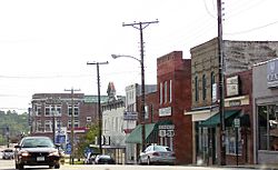
Route 1 in downtown South Hill
|
|

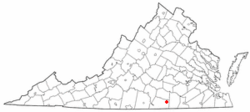
Location of South Hill, Virginia
|
|
| Country | United States |
| State | Virginia |
| County | Mecklenburg |
| Area | |
| • Total | 6.85 sq mi (25.52 km2) |
| • Land | 6.82 sq mi (25.45 km2) |
| • Water | 0.03 sq mi (0.07 km2) |
| Elevation | 436 ft (133 m) |
| Population
(2020)
|
|
| • Total | 4,709 |
| • Estimate
(2019)
|
4,456 |
| • Density | 442.65/sq mi (170.90/km2) |
| Time zone | UTC−5 (Eastern (EST)) |
| • Summer (DST) | UTC−4 (EDT) |
| ZIP code |
23970
|
| Area code(s) | 434 |
| FIPS code | 51-73904 |
| GNIS feature ID | 2391422 |
| Website | http://www.southhillva.org/ |
South Hill is a town located in Mecklenburg County, Virginia, in the United States. In 2020, about 4,709 people lived there.
South Hill is easy to reach because it's near major Interstate and U.S. roads. The town has a hospital that helps people from many nearby rural areas. It also has a market for tobacco and several hotels.
The town of South Hill works closely with its neighbor, La Crosse. A big lake called Kerr Reservoir is not far away. This lake is a popular spot for people who enjoy boating and fishing.
The Colonial Theatre is a historic building in South Hill. It was added to the National Register of Historic Places in 2003. This means it's an important place that helps tell the story of the area.
Contents
Geography of South Hill
South Hill is located at coordinates 36°43′36″N 78°7′50″W / 36.72667°N 78.13056°W.
The town covers a total area of about 6.31 square miles (16.4 square kilometers). Most of this area, about 6.27 square miles (16.4 square kilometers), is land. A small part, about 0.04 square miles (0.1 square kilometers), is water.
Population and People in South Hill
| Historical population | |||
|---|---|---|---|
| Census | Pop. | %± | |
| 1910 | 732 | — | |
| 1920 | 1,074 | 46.7% | |
| 1930 | 1,405 | 30.8% | |
| 1940 | 1,739 | 23.8% | |
| 1950 | 2,153 | 23.8% | |
| 1960 | 2,569 | 19.3% | |
| 1970 | 3,858 | 50.2% | |
| 1980 | 4,347 | 12.7% | |
| 1990 | 4,217 | −3.0% | |
| 2000 | 4,403 | 4.4% | |
| 2010 | 4,650 | 5.6% | |
| 2019 (est.) | 4,456 | −4.2% | |
| U.S. Decennial Census | |||
In 2000, there were 4,403 people living in South Hill. There were 1,809 households, which are groups of people living together in one home. About 1,190 of these were families.
The town had about 696 people per square mile (269 people per square kilometer). There were also 1,988 homes available.
Who Lives in South Hill?
The people in South Hill come from different backgrounds.
- About 58% of the people were White.
- About 39% were African American.
- A small number were Native American or Asian.
- Some people were from other backgrounds or had mixed backgrounds.
- About 1.5% of the population was Hispanic or Latino.
Households and Families
Out of all the households in 2000:
- About 27.8% had children under 18 living with them.
- About 43.7% were married couples living together.
- About 18.6% were homes where a female was the head of the household, and her husband was not present.
- About 34.2% were not families.
The average household had 2.33 people, and the average family had 2.88 people.
Age Groups in Town
The population of South Hill was spread out across different age groups:
- About 23.2% of the people were under 18 years old.
- About 7.6% were between 18 and 24 years old.
- About 26.3% were between 25 and 44 years old.
- About 23.0% were between 45 and 64 years old.
- About 19.9% were 65 years old or older.
The average age in the town was 40 years. For every 100 females, there were about 77.6 males.
See also
 In Spanish: South Hill (Virginia) para niños
 | Janet Taylor Pickett |
 | Synthia Saint James |
 | Howardena Pindell |
 | Faith Ringgold |

