South Huish facts for kids
Quick facts for kids South Huish |
|
|---|---|
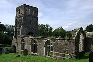
 St Andrew's Church |
|
| Area | 5.8897 km2 (2.2740 sq mi) |
| Population | 473 (2011 census) |
| • Density | 80/km2 (210/sq mi) |
| Civil parish |
|
| District | |
| Shire county | |
| Region | |
| Country | England |
| Sovereign state | United Kingdom |
| EU Parliament | South West England |
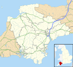
South Huish is a small village and a local area (called a civil parish) in the county of Devon, England. It is located about 4 miles (6.4 km) southwest of a town called Kingsbridge. This area is part of the South Hams district.
The parish of South Huish includes two other small places: Galmpton and Hope Cove. In 2011, about 473 people lived in the parish. By 2017, this number was estimated to be around 436. South Huish is close to other parishes like West Alvington, South Milton, and Malborough. It is also part of the beautiful South Devon Area of Outstanding Natural Beauty, which means it has special protected landscapes.
Contents
Exploring South Huish: What to See
South Huish has some interesting places to visit and learn about.
St Andrew's Church: A Ruined Landmark
One important building is St Andrew's Church. This church is now a ruin, meaning it is partly broken down. Even though it's a ruin, it is a "Grade II* listed building." This means it is a very important historical building in England.
Local School and Nature Reserve
Children in the area often go to Malborough With South Huish Church Of England Primary School, which is in nearby Malborough.
There is also a special place for nature lovers called the South Huish Reserve. This reserve is in a low valley, separated from the sea by sand dunes. These dunes are behind South Milton Sands. The National Trust, a charity that protects special places, has owned the reserve since 2011. Before that, a group called Devon Birds started managing the reserve in 1994. It's a great spot for watching birds and enjoying nature.
Historic Buildings in the Parish
Across the South Huish parish, there are 27 "listed buildings." These are buildings that are officially recognized as having special historical or architectural importance.
The History of South Huish
South Huish has a long and interesting history.
What Does "Huish" Mean?
The name "Huish" comes from an old word that means "household." This suggests that the area was once known for its homes or families.
South Huish in the Domesday Book
South Huish was mentioned in a very old book called the Domesday Book. This book was created in 1086 by William the Conqueror to record information about England. In the Domesday Book, South Huish was called Hewis or Heuis. At that time, only 12 people lived there. Both South Huish and Galmpton were owned by someone named Ralph.
Other Names and Old Divisions
Sometimes, South Huish was also called "Huish South" or simply "Huish." In the past, the parish was part of a larger area known as the Stanborough hundred. A "hundred" was an old way of dividing land in England.
A Discovery from the Past
In 1923, something very interesting was found near South Huish: the site of a "submarine forest." This means that an old forest, which once grew on dry land, is now underwater. It shows how the land and sea levels have changed over many, many years.
 | Mary Eliza Mahoney |
 | Susie King Taylor |
 | Ida Gray |
 | Eliza Ann Grier |


