Sparta, Missouri facts for kids
Quick facts for kids
Sparta, Missouri
|
|
|---|---|

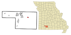
Location of Sparta, Missouri
|
|
| Country | United States |
| State | Missouri |
| County | Christian |
| Area | |
| • Total | 1.24 sq mi (3.21 km2) |
| • Land | 1.24 sq mi (3.21 km2) |
| • Water | 0.00 sq mi (0.00 km2) |
| Elevation | 1,401 ft (427 m) |
| Population
(2020)
|
|
| • Total | 1,876 |
| • Density | 1,514.12/sq mi (584.83/km2) |
| Time zone | UTC-6 (Central (CST)) |
| • Summer (DST) | UTC-5 (CDT) |
| ZIP code |
65753
|
| Area code(s) | 417 |
| FIPS code | 29-69302 |
| GNIS feature ID | 0752280 |
Sparta is a city located in Christian County, Missouri, in the United States. It is in the north-central part of the county. In 2020, about 1,876 people lived there.
Sparta is part of the larger Springfield Metropolitan Area. This means it is connected to the city of Springfield, Missouri and the towns around it.
Contents
History of Sparta
Sparta got its name from Sparta, Tennessee. A post office opened in Sparta, Missouri, in 1876. This helped the community grow and connect with other places.
Railroad and Transportation
In 1883, Sparta got a railroad line. A company called the St. Louis–San Francisco Railway (also known as Frisco) built a track. This track connected Sparta to Ozark, Missouri and Chadwick, Missouri. The railroad made it easier for people and goods to travel.
However, passenger train service stopped in March 1933. The entire railroad line from Ozark to Chadwick was closed in 1934. After that, people had to use other ways to travel and transport goods.
Geography and Location
Sparta is located in the northern part of Christian County. It sits on the southern edge of an area called the Springfield Plateau. This is a high, flat area of land.
The city is found where two main roads meet: Missouri Route 14 and Missouri Route 125. It is about six miles east of Ozark. To the south and southeast, the land becomes more hilly. This is where the small streams of Bull Creek and Swan Creek begin.
The United States Census Bureau says that Sparta covers an area of about 1.24 square miles (3.21 square kilometers). All of this area is land.
Population and People
Sparta has grown quite a bit over the years. Here's how its population has changed:
| Historical population | |||
|---|---|---|---|
| Census | Pop. | %± | |
| 1880 | 23 | — | |
| 1900 | 300 | — | |
| 1910 | 271 | −9.7% | |
| 1920 | 257 | −5.2% | |
| 1930 | 243 | −5.4% | |
| 1940 | 237 | −2.5% | |
| 1950 | 244 | 3.0% | |
| 1960 | 272 | 11.5% | |
| 1970 | 380 | 39.7% | |
| 1980 | 743 | 95.5% | |
| 1990 | 751 | 1.1% | |
| 2000 | 1,144 | 52.3% | |
| 2010 | 1,756 | 53.5% | |
| 2020 | 1,876 | 6.8% | |
| U.S. Decennial Census | |||
Sparta's Population in 2010
In 2010, there were 1,756 people living in Sparta. These people lived in 696 households. A household is a group of people living together in one home. Out of these, 476 were families.
Most of the people in Sparta were White (96.6%). A small number were from other racial groups. About 2.6% of the population was Hispanic or Latino.
The average age in Sparta was about 30.8 years old.
- About 29.3% of the people were under 18 years old.
- About 30.3% were between 25 and 44 years old.
- About 12.1% were 65 years or older.
There were slightly more females (52.9%) than males (47.1%) in the city.
Education in Sparta
The Sparta R-III School District serves the city and the areas around it. This school district teaches students from kindergarten all the way through 12th grade. About 750 students attend schools in the district. Landon Gray has been the leader of the school district since 2021.
Famous People from Sparta
- William T. Tyndall: He was a congressman for Missouri from 1905 to 1907. Before that, he worked as the postmaster in Sparta for several years.
See also
 In Spanish: Sparta (Misuri) para niños
 | Janet Taylor Pickett |
 | Synthia Saint James |
 | Howardena Pindell |
 | Faith Ringgold |

