Spence Field facts for kids
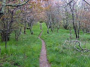
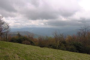
Spence Field is a beautiful open meadow high up in the Great Smoky Mountains. It's like a big, grassy clearing on top of a mountain! This special spot is 4,920 feet (about 1,500 meters) above the sea. Imagine standing there and looking out over everything!
A famous long-distance hiking path, the Appalachian Trail, goes right through Spence Field. There's even a small shelter nearby where hikers can rest overnight.
Spence Field sits right on the border between Tennessee and North Carolina. It's between Blount County in Tennessee and Swain County in North Carolina. This field is about 3,000 feet (914 meters) higher than Cades Cove to the north. It's also about 3,300 feet (1,006 meters) higher than Fontana Lake to the south. The field itself is quite large, covering about 200 acres (0.8 square kilometers).
Spence Field is a busy meeting point for trails in the western part of the Smokies. The Appalachian Trail crosses it from east to west. Other trails, like the Bote Mountain Trail from the north and the Eagle Creek Trail from the south, also meet here. The Bote Mountain Trail connects Spence Field to Cades Cove, Little River Road, and Tremont. The Eagle Creek Trail links Spence Field to the Benton MacKaye Trail and Fontana Lake. If you follow the Appalachian Trail, Thunderhead Mountain is just two miles (3 km) to the east. Gregory Bald is a bit further, about 10 miles (16 km) to the west.
What is a Grassy Bald?
Spence Field is known as a "grassy bald." This is a type of meadow found high up in the Appalachian Mountains. Grassy balds have lots of thick grass but not many trees.
In the late 1800s and early 1900s, Spence Field was part of a huge 24-mile (39 km) pasture. This pasture stretched across the top of the Western Smokies, from Gregory Bald in the west to Silers Bald in the east. But after the Great Smoky Mountains National Park was created in the 1930s, trees and other plants started growing back in many parts of this area, including Spence Field. Today, the park service keeps the grassy balds at Gregory Bald and Andrews Bald open. They let other areas, like Spence Field, slowly return to being forests.
History of Spence Field
Spence Field gets its name from James Spence. He was a settler who built a cabin there in 1830. James and his wife, Caroline Law, were connected to the Cades Cove area. But they really loved the quiet of the high mountains. They lived and raised animals like cows and sheep at Spence Field during the warmer months. They only went down to lower areas when they really had to.
For example, a few days before their son Robert was born in 1840, Caroline Spence walked ten miles by herself to their home in White Oak Cove. She did this to be near neighbors who could help her. But other than emergencies like childbirth or winter coming, they didn't want to leave their mountain home.
John Oliver, who was the first settler in Cades Cove, said that James Spence burned trees and cleared Spence Field in the 1830s. This makes some people think that Spence Field might not have been a natural open area. Even so, people were still using the field as a summer pasture in 1900. Thousands of cows, horses, sheep, and goats grazed there while farmers used the lower lands for growing crops.
Arnold Henry Guyot, who mapped much of the Smokies in the late 1850s, measured the height of "Spence cabin" as 4,910 feet (1,497 meters). The writer Horace Kephart often visited Spence Field in the early 1900s. He especially liked a herder's shack there called "Spencer cabin."
How to Visit Spence Field
You can reach Spence Field by hiking on different trails. The Bote Mountain Trail meets the Appalachian Trail at Spence Field. You can start the Bote Mountain Trail from Little River Road. From there, it's about 7 miles (11 km) to Spence Field.
Another way is from the Lead Cove trailhead, also on Little River Road. This path is about 5 miles (8 km) long to Spence Field. If you start from Cades Cove, using the Anthony Creek Trail from the campground, it's about 5.2 miles (8.4 km) to Spence Field.
The Eagle Creek trailhead is on the north side of Fontana Dam. This trail goes up about 14 miles (23 km) to Spence Field. The Jenkins Ridge Trail is about 9 miles (14 km) long. It connects Spence Field with the quiet Hazel Creek area in the southwestern Smokies.
The Spence Field Shelter is a place where up to 12 backpackers can stay overnight. You need a permit to stay there. The shelter is on the Eagle Creek Trail, about 100 meters south of where it meets the Appalachian Trail. The Russell Field and Mollies Ridge shelters are also nearby, just a few miles to the west.
 | Jessica Watkins |
 | Robert Henry Lawrence Jr. |
 | Mae Jemison |
 | Sian Proctor |
 | Guion Bluford |


