Spiringen facts for kids
Quick facts for kids
Spiringen
|
||
|---|---|---|
 |
||
|
||
| Country | Switzerland | |
| Canton | Uri | |
| District | n.a. | |
| Area | ||
| • Total | 64.68 km2 (24.97 sq mi) | |
| Elevation | 923 m (3,028 ft) | |
| Population
(Dec 2020 )
|
||
| • Total | 842 | |
| • Density | 13.018/km2 (33.716/sq mi) | |
| Postal code |
6464
|
|
| Surrounded by | Bürglen, Glarus Süd (GL), Muotathal (SZ), Schattdorf, Unterschächen | |
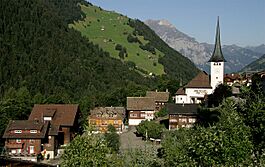
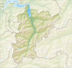
Spiringen is a small village and a municipality in the canton of Uri in Switzerland. It's a special place because it's made of two separate areas. These two parts are divided by the municipality of Unterschächen and the Klausen Pass.
The western part of Spiringen includes the main village. This village is located in the beautiful Schächen Valley. The eastern part is home to the Urner Boden alp. An alp is a high mountain pasture. This area is found above Linthal and the canton of Glarus.
Contents
Exploring Spiringen's Geography
Spiringen covers an area of about 64.7 square kilometers (25 square miles). This area is split into two main sections.
The Western Part of Spiringen
The smaller part of Spiringen is where the village is located. It sits in the valley of the Schächen river. This river flows west towards the Reuss river and then into Lake Lucerne.
This western area is surrounded by other municipalities. To the north and west, you'll find Bürglen and Schattdorf. To the east and south, it borders Unterschächen.
The Eastern Part of Spiringen
About 8 kilometers (5 miles) away, on the other side of Unterschächen and the Klausen Pass, is the second and larger part of Spiringen. This area is known as the Urner Boden meadows. The water from here flows east into the Linth river and then into Lake Zürich.
Besides Unterschächen to its west, this eastern part has other neighbors. To the north, it borders Muotathal in the canton of Schwyz. To the south and east, it's next to Glarus Süd in the canton of Glarus.
How the Land is Used
A big part of Spiringen's land, about 37.5%, is used for farming. Forests cover 17.6% of the area. Only a small portion, 1.4%, has buildings or roads. The rest, about 43.5%, is made up of non-productive land like rivers, glaciers, or mountains.
Spiringen's Population and People
Spiringen has a population of 842 people. A small number of these residents, about 0.9%, are from other countries. Over the past ten years, the number of people living in Spiringen has gone down a little.
Most people in Spiringen speak German, about 99.8% of the population. A very small number speak Italian.
Education and Work in Spiringen
Around 37% of the adults in Spiringen (aged 25-64) have finished higher education. This means they have either gone to a university or a special college called a Fachhochschule.
Spiringen has a very low unemployment rate, which means most people who want to work can find a job.
- Many people work in the primary economic sector. This includes jobs like farming and forestry. About 194 people work in this area, with 88 businesses.
- Fewer people work in the secondary sector. This involves making things, like in factories. There are 38 people and 8 businesses in this sector.
- The tertiary sector includes jobs that provide services, like shops or hotels. About 78 people work here, with 19 businesses.
Population Changes Over Time
Here's a look at how Spiringen's population has changed over the years:
| Year | Population |
|---|---|
| 1970 | 946 |
| 1980 | 943 |
| 1990 | 921 |
| 2000 | 963 |
| 2005 | 943 |
| 2007 | 909 |
See also
 In Spanish: Spiringen para niños
 | Victor J. Glover |
 | Yvonne Cagle |
 | Jeanette Epps |
 | Bernard A. Harris Jr. |


