
Muotathal facts for kids
Quick facts for kids
Muotathal
|
||
|---|---|---|
 |
||
|
||

Muotathal
Location in Switzerland

Muotathal
Location in Canton of Schwyz
|
||
| Country | Switzerland | |
| Canton | Schwyz | |
| District | Schwyz | |
| Area | ||
| • Total | 172.14 km2 (66.46 sq mi) | |
| Elevation
(Church Muotathal)
|
626 m (2,054 ft) | |
| Population
(Dec 2020 )
|
||
| • Total | 3,470 | |
| • Density | 20.158/km2 (52.21/sq mi) | |
| Demonym(s) | German: Muotathaler/-in | |
| Postal code |
6436
|
|
| Localities | Ried, Schachen, Wil, Hinterthal, Chrüz, Pragel, Bisisthal, Glattalp, Toralp, Charetalp, Goldplangg | |
| Surrounded by | Bürglen (UR), Glarus (GL), Glarus Süd (GL), Illgau, Innerthal, Morschach, Oberiberg, Riemenstalden, Spiringen (UR), Schwyz, Unteriberg, Unterschächen (UR) | |

Muotathal is a village and a municipality in the canton of Schwyz in Switzerland. It is located in a beautiful valley called the Muotatal. This valley gets its name from the Muota river, which flows into Lake Lucerne near Brunnen.
Contents
History of Muotathal

Muotathal was first mentioned in old writings in the year 1246.
A very important event happened here in 1799. During a big war, a smaller group of Russian soldiers fought against French troops in the Muotatal. Even though the Russians were outnumbered, they won a major victory. This battle helped save the main Russian army from being defeated.
Geography of Muotathal

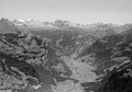
Muotathal village is found in the valley of the Muota river. The municipality (like a local government area) is in a series of valleys on the eastern side of the canton. It shares borders with the cantons of Uri and Glarus. Muotathal is one of the largest municipalities in Switzerland by land area.
The area includes smaller parts like Ried, Schachen, Wil, and Hinterthal. There's also a hamlet called Bisisthal further up the Muota river. The municipality also has many high mountain pastures, known as alps, such as Glattalp.
About one-third of Muotathal's land is used for farming. Another big part is covered by forests. A small amount of land has buildings and roads, while a large portion is made up of mountains, rivers, and glaciers.
Muotathal is also home to the entrance of the Hölloch cave. This cave is over 200 kilometers (about 124 miles) long! It is the longest cave in Switzerland and the second-longest in Europe.
People of Muotathal
Muotathal has a population of about 3,500 people. A small part of the population, around 5%, are people from other countries. Most people in Muotathal speak German. Albanian is the second most common language.
The population includes many young people. About 30% are under 19 years old. There's a good mix of adults and older people too.
When it comes to jobs, many people in Muotathal work in farming. Others work in manufacturing (making things) or in services (like shops and tourism). The unemployment rate is very low, which means most people who want to work can find a job.
Most people in Muotathal are Roman Catholic. A smaller number belong to other Christian churches or are Islamic. Some people do not belong to any church.
Population Changes Over Time
The number of people living in Muotathal has changed over the years. Here's how the population has grown:
- 1850: 1,680 people
- 1900: 2,221 people
- 1950: 2,475 people
- 2000: 3,556 people
- 2007: 3,556 people
Weather in Muotathal
Muotathal gets a lot of rain each year, with an average of 157.8 rainy days. The wettest month is usually June, when it rains for about 16 days. October is often the driest month.
Images for kids
-
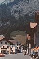
Muotathal during the 1973 ICF Canoe Slalom World Championships
-
Muotathal in 1973
-
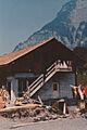
Muotathal in 1973
-
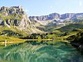
Lake Waldisee in the Bisistal southeast of Muotathal, north of the Glatten mountain
-
Aerial view (1958)


See also
 In Spanish: Muotathal para niños
