Spring Creek (Fort Collins, Colorado) facts for kids
Quick facts for kids Spring Creek |
|
|---|---|

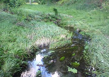
Spring Creek in 2007 following minor flooding; note the effect of the water flow on nearby vegetation
|
|
| Physical characteristics | |
| Main source | 40°31′48″N 105°08′30″W / 40.53000°N 105.14167°W |
| River mouth | Confluence with Cache la Poudre 4,898 ft (1,493 m) 40°34′08″N 105°01′39″W / 40.56889°N 105.02750°W |
| Basin features | |
| Progression | Cache la Poudre— South Platte—Platte— Missouri—Mississippi |
Spring Creek is a small river, about 12.7 miles (20.4 kilometers) long. It flows through Colorado in the United States. Spring Creek is a branch of the Cache La Poudre River.
This creek starts near Horsetooth Mountain inside Horsetooth Mountain Park. This park is just west of Fort Collins, Colorado. From there, the creek flows into Horsetooth Reservoir. After leaving the reservoir through Spring Canyon Dam, Spring Creek goes through the middle of Fort Collins. It passes just south of Colorado State University. A popular path called the Spring Creek Trail runs alongside the creek for most of its journey through the city.
Contents
Exploring the Spring Creek Trail
The Spring Creek Trail is a great place to explore in Fort Collins. It follows Spring Creek through several parks. The trail starts at Spring Canyon Park near Overland Trail. It ends where Spring Creek meets the Poudre River. Here, it connects with the Poudre Trail.
Trail Features and Length
The Spring Creek Trail goes under Taft Hill Road through a new tunnel. This makes it safer and easier to use. The trail continues through Spring Canyon Community Park. It also passes by the Pineridge Natural Area. The Spring Creek Trail is about 6.6 miles (10.6 kilometers) long. It's a very popular spot for walking, running, and biking.
The 1997 Spring Creek Flood Event
In July 1997, Fort Collins experienced a major flood. From July 27 to July 28, about 14.5 inches (37 cm) of rain fell. This heavy rain caused Spring Creek to overflow its banks. The small creek turned into a powerful, fast-moving river.
Impact of the Flood on Fort Collins
The flood caused a lot of damage in the city. Sadly, five people lost their lives. The flood also caused about $200 million in damage to homes and public buildings. This made it the worst natural disaster Fort Collins had ever seen. The campus and buildings at Colorado State University were also badly damaged.
Recovery and New Programs
Soon after the flood, President Clinton declared it a disaster. This helped Larimer County, where Fort Collins is located, get $5.2 million in aid. This money helped individuals affected by the flood. Colorado State University received $1.2 million to fix its damaged buildings. Studies showed that Horsetooth Reservoir helped reduce the flood's impact. The reservoir's water level rose by 50 cm, which held back a lot of water.
The Spring Creek flood also led to something positive. It inspired a national program called CoCoRaHS. This stands for the Community Collaborative Rain, Hail and Snow Network. Volunteers across the country measure rain, hail, and snow. This helps scientists and weather forecasters understand weather patterns better.
 | Anna J. Cooper |
 | Mary McLeod Bethune |
 | Lillie Mae Bradford |


